Apparently someone on this thread said it was “enough” and carry On. Usually agree with that person too. Still have multiple engines in there still in IA mode… from 2 days ago when the activity doubled. I know multiple fires with life n property threat but this should be split into its own Initial Attack.
For those saying there needs to be an I.A. thread please feel free to start one, otherwise let’s just carry on. It’s chaos right now but it will eventually slow down. Keep calm, stay hydrated, and check your lces.
Under a evacuation warning
https://mobile.twitter.com/sccounty?ref_src=twsrc^google|twcamp^serp|twgr^author
Anyone know where to get the most frequently updated hotspots maps?
https://maps.nwcg.gov/sa/
This is the best I have found so far but I know it’s not real time updates. I’d love to have points to compare. We’re close to UCSC and using for decision making. Any other effective data sources would be amazing, too.
Thank you!
Airtac requested 5 or 6 airtankers, sounds like for the north zone (San Mateo County) will be interesting to see how much he gets
https://www.arcgis.com/apps/webappviewer/index.html?id=2ff1677111ae4018ac705fcce7c3312f&extent=-13410535.7911%2C4212086.9449%2C-13402624.5586%2C4223208.5325%2C102100
Try that, depends on the time it was updated
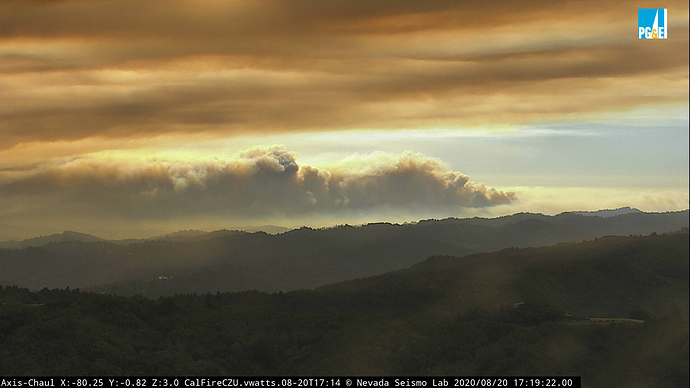
Looks like it’s cranking again:
alertwildfire.org/northbay/?camera=Axis-MtChaul
No straight up header, just cooking in the canyons getting ready for its next blow out.
Scanner link:
Radar imagery has been suggesting pretty intense burning for past 2-3 hours on the fire’s eastern flank, with the highest reflectivities I’ve seen since earlier this week. This may be a “tilted plume” kind of situation, now that the N/NW winds have come up a bit, and the fire cam snapshots broadly support that at the moment.
New evac order for LaHonda in San Mateo county.
That fire gets into Bear Creek drainage all sorts of new problems are gonna start.
They just issued evacuation orders for everything west of Hwy 17, from the summit all the way down through Scotts Valley. Also the UCSC Campus.
Per AA, fog intruding into the incident. All fixed wing done for the night.
Per AA. Big Run into Scotts Valley, multiple homes lost and threatened, before departing.
Have not heard that…you sure Scotts Valley ? There is zero local dispatches to Scotts Valley…think you might have misunderstood
I want to say I’m 99% percent sure AA said Scotts valley
Did hear him mention Boulder creek push but I did miss the first part of his report. Like I said though, there is zero dispatches for that area…
From CAFireScanner: “Reports of multiple structures on fire in the E Hilton Dr area around the Boulder Creek golf course. AA140 was overhead doing recon, reported heavy structure loss + a marine layer w/ ceiling of 1000ft inbound to the fire area.”
