
Kirkwood weather station
Current Temperature: 62°F
Relative Humidity: 25%
Current Wind Speed: 20 MPH
Wind Gust: 27 MPH
Observation Timestamp: 15:45 August 29, 2021 (Pacific Daylight Time)
Tahoe Keys Weather station
Current Temperature: 82°F
Relative Humidity: 14%
Current Wind Speed: 7 MPH
Wind Gust: 19 MPH
Observation Timestamp: 16:00 August 29, 2021 (Pacific Daylight Time)
It sounds like they (LE units headed for Tahoe Basin) just got turned around trying to go up 50 and were rerouted out 80 and around.
Mandatory evac now for Myers/Christmas Valley…just got the alert on my phone
Be safe - get out while you can
This is the El Dorado County Sheriff’s Office with an emergency message for your area. There is currently a fire in your area that is under a Mandatory evacuation order. You must leave your residence immediately in a safe manner. Please follow Emergency personnel’s direction to leave the area. This is an immediate evacuation order for the area east of echo summit, Christmas Valley from Highway 89 south to the Alpine County / El Dorado County Line. Meyers, east as far as the Elks Club / Sawmill Roads. Pioneer Trail as far north as Elks Club. North Upper Truckee through to the intersection with Tahoe Mountain Road and Lake Tahoe Blvd. Please evacuate the area using eastbound Highway 50 to the State of Nevada. If needed there is a Red Cross Shelter at the Douglas County Community Center in Gardnerville, Nevada
Got to Leave.

The scoopers are back working near leek springs.
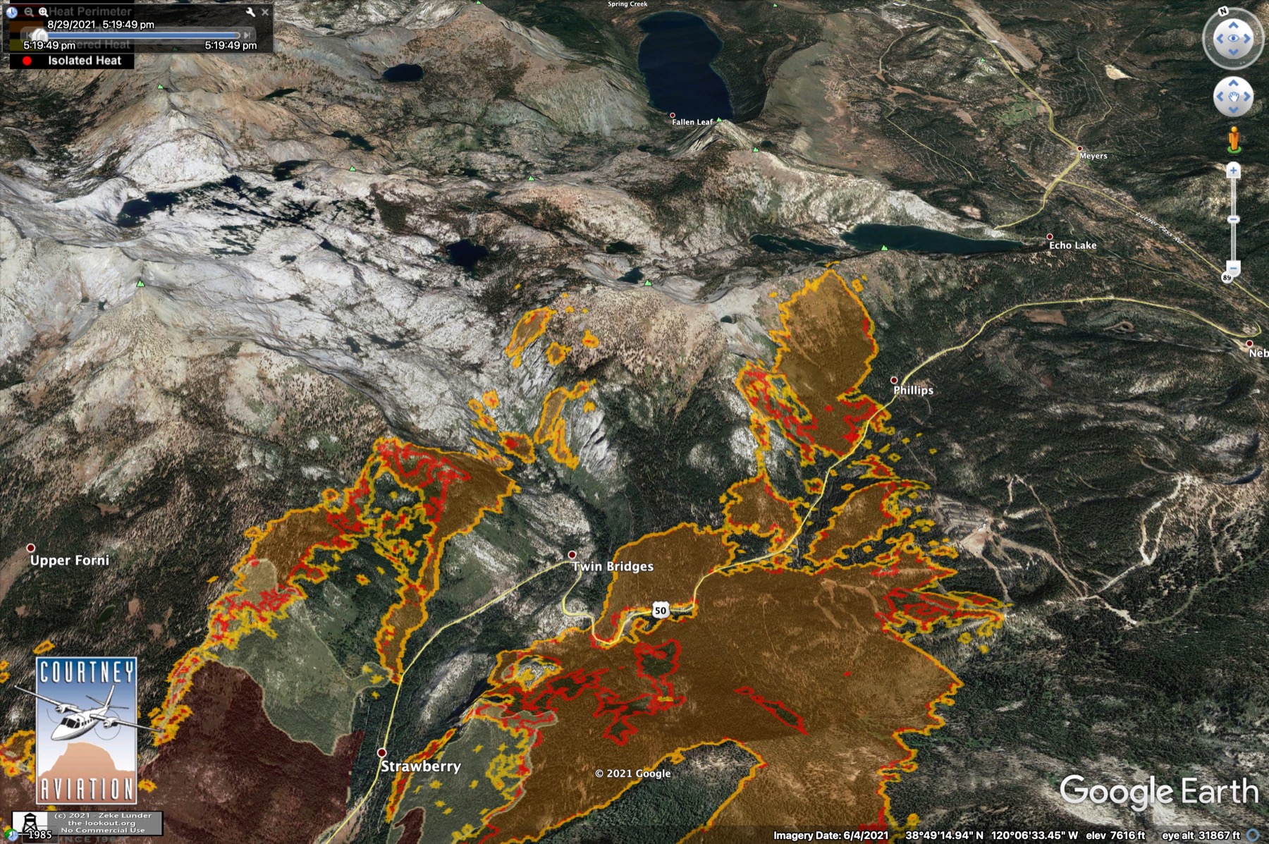
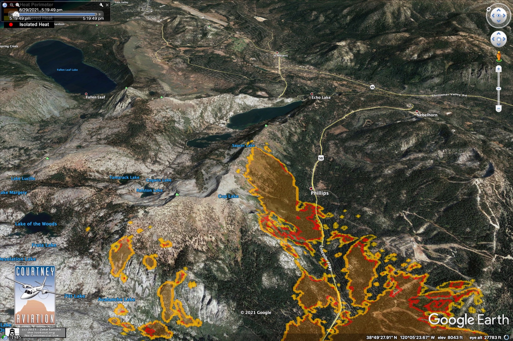
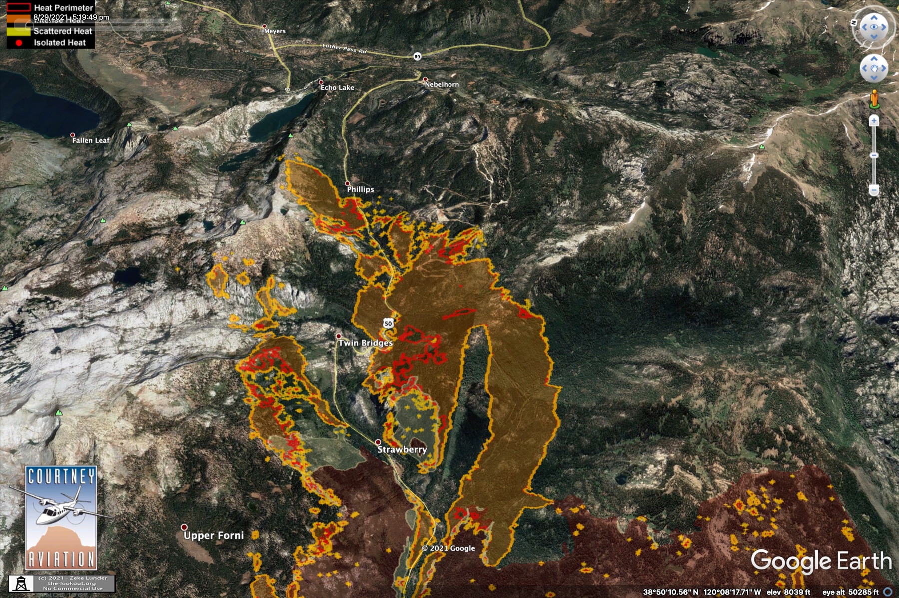
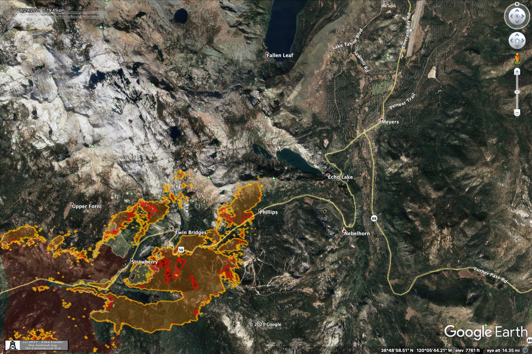
1630 IR flight, east end of the fire. This footprint is noticeably smaller in a few places than the 3pm VIIRS flight, suggesting significant plume-related errors with the VIIRS pass:

168,387 acres
13% containment
Per Inciweb
@mjacobs and for all of you looking at VIIRS, MODIS, GOES please take a moment to learn/understand the spatial resolution of these sensors.


2 posts were merged into an existing topic: CA-ENF-Caldor?
And also realize that these satellites wobble a little tiny bit. But the lever arm from a satellite is gigantic. I don’t know the exact numbers they differ based on the optics but it is like 1/100 of degree error in measurement of the attitude of a satellite can put a pixel a mile off.
It’s a whole bunch of hard work (not a miracle) that make the spots come even close to where they belong. And don’t forget that you need a good earth surface model to project the spots on.
That should help you be cautious in your interpretation of satellite hot spots.
Homewood ski resort RAWS report :
Near Meeks Bay (west side of the big lake) and NE of the head of the fire.
It’s critical up the west shore and the humidity recovery is…well reversing at 8pm reading.
12pm Avg.wind=7.0 Direction=265 Gusts=19.0 air temp=80.0 Fuel temp=95.0 Fuel stick=5.3 RH=9
1 pm Avg.Wind=10.0 Direction=250 Gusts=23.0 air temp=79 Fuel temp=93.0 Fuel stick=5.1 RH=10
2 pm Avg.Wind=7.0 Direction=233 Gusts=26.0 Air temp=80.0 Fuel temp=92.0 Fuel stick=5.1 RH=12
3 pm Avg.Wind=9.0 Direction=257 Gusts=24.0 Air temp=78.0 Fuel temp=87.0 Fuel stick=4.7 RH=13
4 pm Avg.Wind=11.0 Direction=254 Gusts=22.0 Air temp=76.0 Fuel temp=81.0 Fuel stick=4.6 RH=14
5 pm Avg.Wind=6.0 Direction=254 Gusts=19.0 Air temp=74.0 Fuel temp=75.0 Fuel stick=4.5 RH=16
6 pm Avg.Wind=5.0 Direction=235 Gusts=14.0 Air temp=69.0 Fuel temp=65.0 Fuel stick=4.4 RH=19
7 pm Avg.wind=3.0 Direction=262 Gusts=10.0 Air temp=66.0 Fuel temp=59.0 Fuel stick=4.4 RH=21
8 pm Gusts=12 Air temp=67 Fuel stick=4.3 RH=18
Want to interrogate it more:
https://raws.dri.edu/cgi-bin/rawMAIN.pl?caCHOM
Central Cal map of RAWS stations (with fuel sticks):
https://raws.dri.edu/wraws/ccaF.html
Satellite hot spots are interpretational. They are good indicative tools. Anyone who works with these mapping sources should know that. Having said that…anyone who reads them should know that as well.
KML files filtered from 083021 data package found here:
https://ftp.wildfire.gov/public/incident_specific_data/calif_n/!CALFIRE/!2021_Incidents/CA-ENF-024030_Caldor/GIS/IncidentData/20210830/
For import into CalTopo, Google Earth, etc. Can’t vouch for how accurate they keep the data vs what’s really on the ground.
Completed Dozer Line:
Completed All Types Of Line:
Planned Dozer and Hand Line:
Branch 10 Ops map with afternoon IR. https://ftp.wildfire.gov/public/incident_specific_data/calif_n/!2021_FEDERAL_Incidents/CA-ENF-024030_Caldor/GIS/Products/20210830/OPS_BRANCH%2010_20210829_2235_Caldor_CAENF024030_0829.pdf
Firing ops are underway in division m & n along dozer line coming off leek tying into 88.ALERTWildfire | Tahoe
177,260 Acres
14% contained