Have they already lost the Morman Emigrant Trail?
Yes. As of about 2 hours ago
spot weather shows the winds switching to the northeast tonight and remaining northeast into Thursday. This will help them hold it along Mormon Emigrant trail and south of 50. It will not help for communities west of the current fire perimeter, as the line of fire is in many drainage’s aligned with that wind direction.
2 Likes
Unfortunately the situation presents itself with an impossible hopeful outcome, which is why this fire is occurring in such a bad place. Either it continues in its current form and experiences massive growth, and not too many homes, or the wind event prevails and it gets pushed towards a lot more homes and lives.
Either way, this thing is bad! Just hope everyone stays frosty and listens to the evac orders
5 Likes
Well folks. Another long day transitions into another long night. Let me say “in the blind” for the troops out there on the Caldor (and others)
Even though large tracts of land and many acres have fallen you shall not fail. Though the task seems disheartening as you now come on the line, know that you are in our hearts and dreams tonight.
This is your finest hour…
31 Likes
Ugh! We need “head down in defeat” emoji. I was really hoping that with all the work they’ve done clearing it that it was the stronghold. Box will be much bigger now.
3 Likes
Hopefully the winds won’t surface out of the NE. They usually don’t materialize in this part of CA except farther into Fall. I’m guessing that they stay out of the SW and that will mean a semi good humidity recovery as well. At least much better than if the NE winds develop.
3 Likes
This year nothing would surprise me
2 Likes
The northerly winds have made it to the Dixie fire (possibly helping Susanville) so we’ll see.
2 Likes

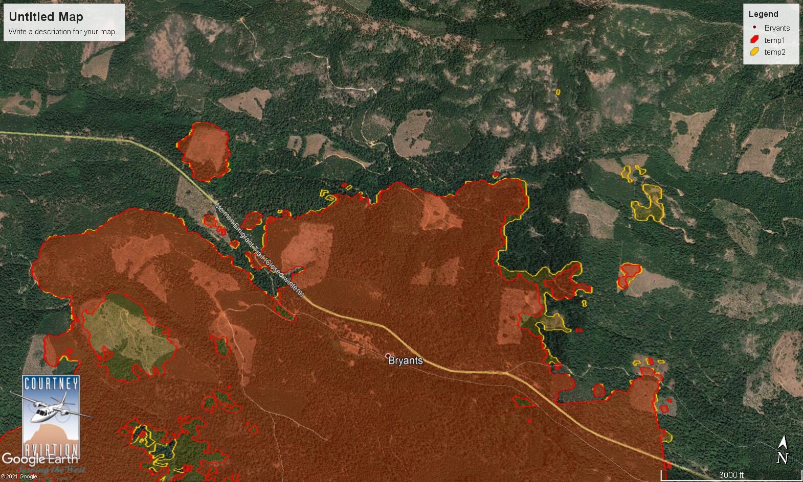
For those that are debating whether to stay or go, or what the affects are of the wind change; today with the N/NE wind driving the fire there was a huge amount of growth in that direction. I posted earlier a sat shot that looked like it was 9 mile wide fire front (to the east). Todays growth created a left flank at least as long. Fire “tends” not to grow quickly on the flanks. These flanks will not be secured by tomorrow, they will be open line.
If this wind does surface, the entire left flank can become a head fire and possibly have explosive growth westward. There is nothing anyone can do when the wind is blowing 20-30 mph.
If you’re east of 49 plan for this. This is a very dangerous fire/situation.
If it doesn’t come to pass you did good training for the future.
17 Likes

Yep. Looks like it established about 1930.
1 Like
This went from nothing to major real quick. Stay safe.
2 Likes
Already very outdated, but false-color long-wave IR image from the Sentinel satellite pass at noon today. https://caltopo.com/map.html#ll=38.65146,-120.4854&z=13&b=mbt&o=sentinel_burn-0&n=1

5 Likes
Coulson’s S61 helitanker HT61, that has been stationed at Camarillo airport this summer, left for the fire this evening about 1900.
3 Likes
Per Cal Fire at 2300hrs
Evacuation Warnings:
• North of Slab Creek to Wentworth Springs Road between Sand Mountain and Loon Lake.
• Mosquito Road from the bridge North to include the Community of Swansboro.
• North of Highway 50 to Slab Creek between Smith Flat and Snows Road.
• South of Highway 50 to Pleasant Valley between Smith Flat and Snows Road, and North of Pleasant Valley between Holm and Newtown.
• South of Pleasant Valley between Bucks Bar Road and Newtown Road, East of Bucks Bar Road to Mt Aukum Road.
• Southwest of Bucks Bar Road to Ladies Valley Road including the community of Outingdale, Ant Hill Road, Perry Creek Road and Sand Ridge between Ladies Valley Road and Bucks Bar Road.
• East of Mt Aukum Road (E16) from Bucks Bar Road to Omo Ranch Road. North of Omo Ranch Road to the intersection of Omo Ranch Road and Fairplay Road.
• South of Omo Ranch to the El Dorado County Line between Mt Aukum Road (E16) and Fairplay Road to include Coyoteville Road, Cedar Creek and all tributary roads.
1 Like
Per AA112, 55,000 acres. Heat is on the south and southeast side. they are emailing the map just completed to night ops now.
5 Likes
