The had an FS engine there all day parked beside it.
Plus a lot of prep was done around the site.
Come ooon Sierra Granite. Help out Echo tonight.
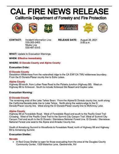
Evacuation Warnings just went to CA/NV Stateline
I want to ask if this could go all the way through South Lake Tahoe? Does “all the way up” mean North to Homewood?
Could you give me a link to the notice? I live in Stateline, NV
The EDSO Arcgis map does not fall in line with what CAL FIRE AEU Has posted on FB and Twitter
They are still there. Run the video back 15 minutes and you can see them, with their flashlights. Dedication!
http://www.alertwildfire.org/tahoe/index.html?camera=Axis-Leek&v=fd40740
Well given that the Sheriff has the legal authority for Evacuation, id go with that. Please remember that while AEU is certainly embedded with IMT 6, Team 6 is in command of the fire.
EDSO map shows Warning boundary at Al Tahoe Blvd. But, I wouldn’t quibble about a mile or two to Stateline, given the weather prediction.
There’s roughly 20 engines, numerous dozers, crews, and task force resources in the Meyers area actively prepping, evacuating, and holding for the fire front.
To me that is bat shit crazy. I’ve been watching them all night. Trained professionals that know what they are doing! A half dozen or more just went off to the left of the camera! Praying for them!
Read the notice from the Sheriff 9pm update for specifics.
If I were anywhere near south lake, I would be gone. Especially after having to live through Paradise. This is unbelievable. Just absolutely unbelievable.
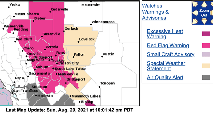
URGENT - FIRE WEATHER MESSAGE
National Weather Service Sacramento CA
954 PM PDT Sun Aug 29
…Red Flag Warning Monday through Tuesday Evening for the Sierra
Nevada and Southern Cascades…
.Gusty west/southwest winds will continue over the the Northern
Sierra Nevada and southern Cascades. The strongest winds are
expected late Monday morning through Tuesday evening, which
combined with extremely dry fuels and low humidity will lead to
critical fire weather conditions. New or existing wildfires will
have the potential for rapid spread and growth under these
conditions.
-
WIND…West to southwest wind gusts of 20 to 35 mph, locally
higher at ridgetops and peaks. Strongest winds expected over
higher elevations and near favorably oriented canyons. -
HUMIDITY…Minimum humidity of 8 to 20 percent with moderate
to poor overnight recoveries. -
IMPACTS…Any active fires or new fires that develop will
likely spread rapidly. Outdoor burning is not recommended.
The online gis map of the evac zones seems to be phasing in the different neighborhoods towards Stateline. Maybe trying to prevent traffic getting clogged…? It’s only a warning, so they should just have the shading match the Calfire news release. Luckily many have already left who have the financial means to avoid the smoke.
It’s the folks without cars and the resources to get out quickly that worries me.
The day was bright heat as fire activity roared and spread on the northern fires from GOES satellite:
This fire right lower corner. You can zoom in and out but it might be slow.
https://rammb-slider.cira.colostate.edu/?sat=goes-17&sec=conus&x=7434.099609375&y=3440&z=4&angle=0&im=18&ts=1&st=0&et=0&speed=220&motion=loop&maps[borders]=white&lat=0&p[0]=band_02&p[1]=cira_natural_fire_color&opacity[0]=1&opacity[1]=0.5&pause=0&slider=-1&hide_controls=0&mouse_draw=0&follow_feature=0&follow_hide=0&s=rammb-slider&draw_color=FFD700&draw_width=6


