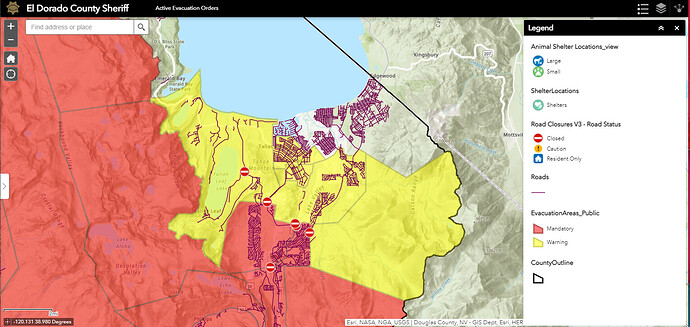
Arcgis map now updated reflecting current evac warnings for all of the basin ArcGIS Web Application
Looks like its at Echo now
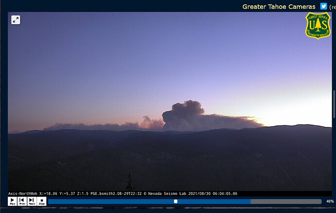
This morning’s column doesn’t look like it is from the firing operation. It looks more to be up Hwy 50. Good luck to all today!
Almost 21k acres in growth for this last op period. Seems like today is a crucial day for this incident.
24 hr progression map.
0604 this morning from the North Mokelumne camera. She’s waking up early today.
Not unexpected. Still unfortunate. LCES
Division m or l north of highway 88.
Likely several get out of the way moments today in the basin. It’s a house, sure it has memories and valuables and family treasures, but nothing is more important than life.
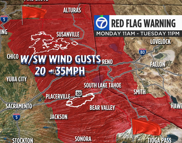
All eyes on Tahoe Basin today.
LCES first, last and always LCES.
Resource orders for Basin? I expected large orders of any type engines last night and havent heard anything? Out of state equipment is coming but Id expect more of the OES army, unless its all on the Dixie still
I heard there was at least a 50 Strike Team Immediate Need Engine order in the hopper and another report of 100 Strike Teams. All unsubstantiated.
IC at morning briefing said the fire was being zoned with CIIMT 4- Rocky Opliger taking the east zone. Timing TBD.
I wish that would have been done three days ago or even sooner but it is what it is. I respect CIIMT-4 and they’ve tackled some challenging incidents. Getting a fire at this point in the game with as many variables stacked against them (fuels, weather, limited resources, WUI, political interests) as it is all coming to head would be a nightmare if you ask me. Burn op’s are very labor intensive and require a lot of planning. It’s one of the hardest fire suppression tactics to pull off on a type I incident. Having said that, priorities on this fire do have me scratching my head. Several windows of good weather, and minimal fire spread went by with resources staging and lot’s of point protection where resources may have been put to use better with an aggressive fire op. As always hard to say without knowing the full picture. Really praying that no lives are lost today.
From this mornings (8/30/21) 209 Report:
- Critical Resource Needs in 12-, 24-, 48-, and 72-hour timeframes and beyond to meet critical incident objectives. List resource category, kind, and/or type, and amount needed, in priority order:
11 - Type 1 Engine Strike teams (A)
50 - Type 3 Engine Strike teams (C)
23 - Hand Crew Strike teams (G)
2 - IHC Hand Crews
14 - Hand Crew any type
26 - Dozers any type
4 - Dozer strike teams (L)
14 - Water tenders
8 - Masticaters
AIR OPS:
12 hours: 1 - HLCO
1 - Helibase manager
1 - Deck
1 - Mobile Retardant Plant 1 - UAS with aerial ignition
OVERHEAD:
1 - OSC
1 - OPBD
8 - DIVS
7 - FELB 45 - HEQB 8 - FALM
Interestingly, the work assignments for DIV J and DIV K, the two divisions closest to the basin are:
Construct control lines as direct as possible.
Plan secondary control lines, begin if possible.
Fall tress that will threaten control lines.
Hold fire within current control lines.
Nothing about structure protection at all.
K is a new division, but is lightly staffed with only five single resource engines (4 from AEU) a couple of crew strike teams and some water tenders and faller modules.
I’ve seen Team 4 is in-briefing to the TMU this afternoon. Maybe they’ll be taking care of the Basin? Seems likely the fire will get there first. I know a lack of resource constraints is a huge problem, and I suspect the IMT is stressed beyond belief trying to spread what they have around. Still, it’s surprising to not see anything about structure protection in the Basin in today’s IAP. Stand by for large dispatches of engines, code 3, to the incident this afternoon?
It seems the IAP has read the same for most all thee divisions throughout the incident…
