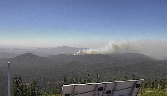
New start in the Gerle Creek area of ENF. Appears to have some wind on it
North of Union Valley Reservoir.
Hell Hole RAWS showing winds 30mph from east with gusts to 50.
https://raws.dri.edu/cgi-bin/rawMAIN.pl?caCHEL
It may slow down when it runs into the King Fire, but it will likely haul ass thru all of the clearcuts to the south of King Fire. It is early in the day, but we should be thinking way out ahead of this one, like Georgetown, Volcanoville, Coloma, Placerville.
http://www.alertwildfire.org/shastamodoc/index.html?camera=Axis-BigHill
http://www.alertwildfire.org/shastamodoc/index.html?camera=Axis-Bunker
South Fork Rd. Aircraft on Order.
That fire is kicking.
And there is room to run
1 USFS Engine is stationed in the Crystal basin. Next engine could be 30+ minutes out from this. Not a good area to be needing resources.
Any communities near this area? This thing looks like it is picking up steam fast!
What fire is that on the Lexington Hill camera???
Negative. Georgetown is the closest. Still a ways away. But this is very remote and difficult access. With the RAWS in that area, they will be In for a fight
Holy smokes! That’s the Bear/Claremont.
The what?? Haven’t even heard that fire mentioned yet…That thing is ripping!!!
Part of the North Complex. The Bear & Claremont are west/southwest of Quincy.
Part of the PNF-North Complex.
And most likely limited resources
The Rubicon Trail Group is working on getting people off the Rubicon Jeep Trial. Monitoring KA6GWY repeater 146.805.
I imagine most Forests are close to drawdown.
God awful steep in the Middle Fork of the Feather…
Nobody has posted in that thread in 4 days and its cooking like that???
Good link to see how the wind is effecting the fires you can see this fire just west of Tahoe
This is NOT the Feather River. This is the American River Drainage. ENF not PNF
There’s mixed conversation here, someone asked about the Lexington camera, which I think is pointed at Bear/Claremont Fires in Middle Feather.
