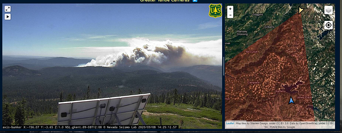
Winds have been light on it for the last 4 days or so so there wasn’t much going on. But now with winds ripping down the rugged Middle Fork Canyon…
Take the PNF conversation to that thread…
Can anyone confirm a name for the new Fire?. I’d like this thread to be for the new fire. The other can be updated in the PNF-Thread that already exists. Thank you.
CA-ENF-FORK
New fire is the Fork incident
Thank you, lets leave that here and move the other discussion to the PNF Thread. Also, if anyone is willing please start an IA, Looks like we will need it. This can stay as Q and D. Thanks.
Copter 404 enroute from Columbia eta 1215
This is north of Union Valley Reservoir headed into the Rubicon drainage.
The cross on the cameras put it about a mile west northwest of Gerle Creek Divide Resevoir.
https://www.google.com/maps/@38.9740001,-120.4207771,15.17z/data=!5m1!1e4
Airshow canceled due to turbulence.
Correct. All of that area burned in the King Fire, which is now six year old snags, brush, and reproduction. Just checked the wind at Duncan Peak (TNF). Sustained 25, gusts to 38, out of the northeast. As IC(T), just said, this has the the potential to “go big”.
TFR 10 miles on the incident
Just started really taking off in last 15 minutes.
Listening to Camino now sounds like it’s making a big push towards hell hole
It’s been going west down the Rubicon drainage, it’s now pushing north west.
Hell Hole is north and a bit east of the fire. Unless we have a wind shift to the our normal SW winds (which will be up canyon for the Rubicon drainage), it will continue to push west, down into the Rubicon drainage, and the King Fire scar. All bets are off, if (when) that happens. Now, having said all that, ENF personnel and ELDO sheriff are evacuating Loon Lake area and the Rubicon Trail, just in case the northeast wind relaxes.
The Placer County Sheriff’s Office said deputies are evacuating the areas surrounding Hell Hole and French Meadows as a precaution.
The only thing that makes sense if get folks out NOW before a wind shift back to the normal prevailing direction (a la the infamous King run of 12 (?) miles in that one day). Right now, we have easterly/north easterly flow at Lake Tahoe. I’m not sure when it is supposed to change back.
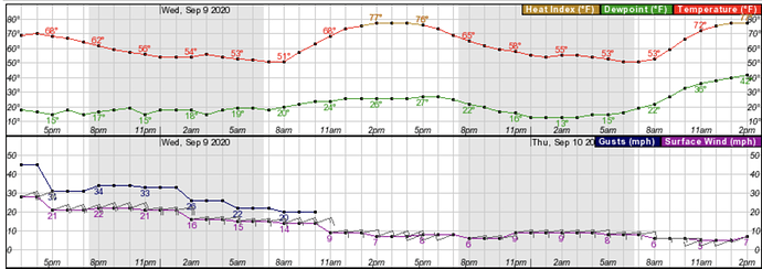
According to NWS point forecast, sustained winds from the east @ 14-22mph with gust to 35 through 8 a.m. Wednesday.
https://forecast.weather.gov/MapClick.php?lat=38.991146087646484&lon=-120.37850952148438&unit=0&lg=english&FcstType=graphical

