SQF Forest (Sequoia) sending 2 Hand crews and overhead I have heard dispatched today.
4 Likes
Why are there new updates on this fire. Was there an entrapment yesterday. I am down on the McFarland with crappie cell service.
I’ve been checking the KNF Facebook page, which has daily updates and maps. There was no mention of entrapment there though they did say the fire was unusually active at night and difficult to contain on the southern end due to topography.
It’s been growing by a thousand acres or so every day but has lines that have held on the northwest side.
2 Likes
Any news of a large spitfire overnight? IR is showing a spot between The Whaleback and Ash Creek Mtn. Right up against Military Pass?
It looks like it grew considerably on the southwest side, which is towards the area you are talking about. There was also talk of possible thunderstorms yesterday though I haven’t heard of any confirmed lightning strikes or new fires.
From KNF:
Antelope Fire crews challenged under Red Flag conditions
August 13, 2021 Daily Update:
Start Date: August 1, 2021
Location: Antelope Creek drainage Fuels: Mixed conifer transitioning to ponderosa pine with a sage bitterbrush understory
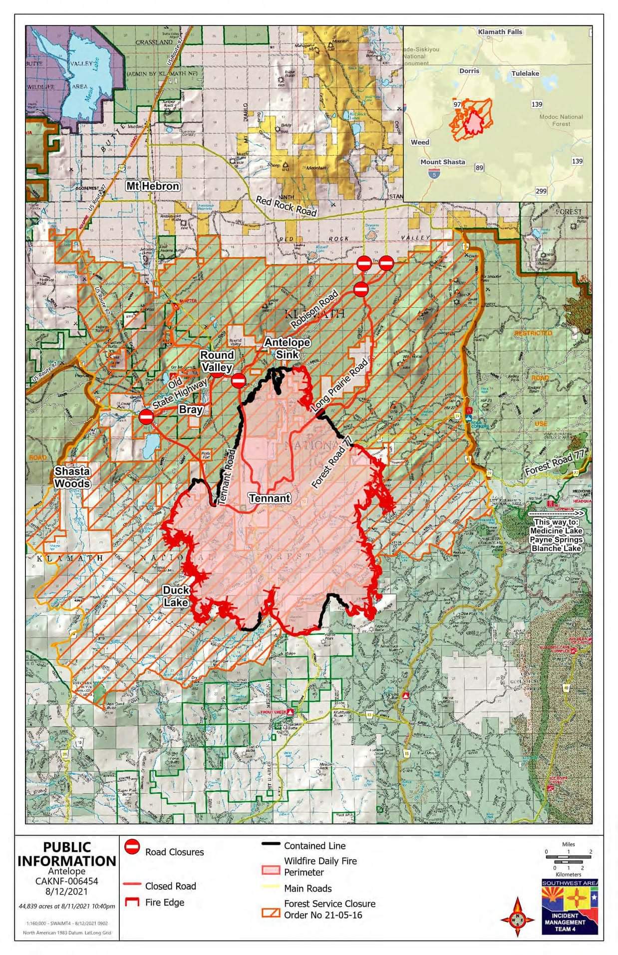
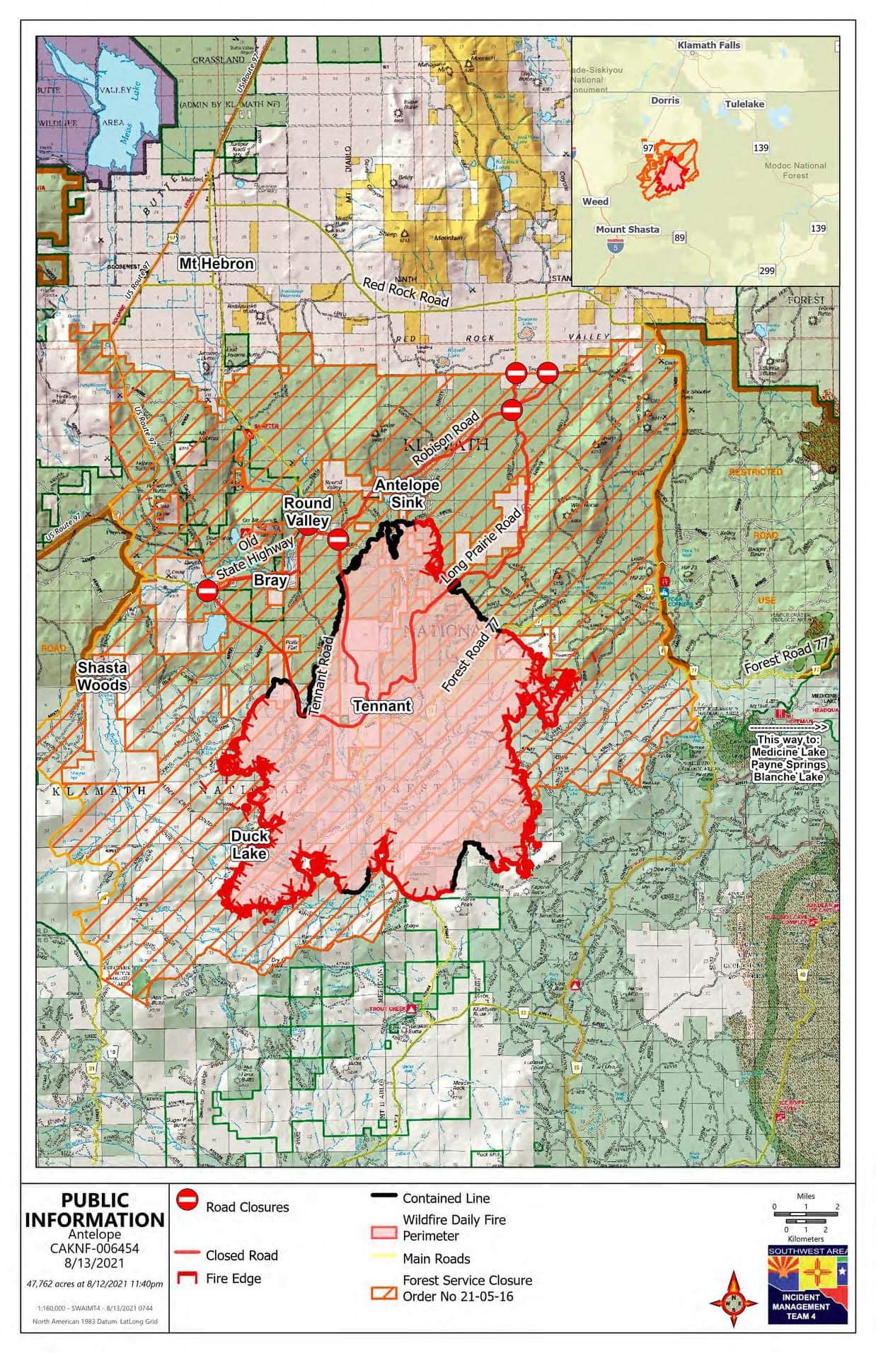
Acres: 47,762 acres
Cause: Lightning
Containment: 24%
Total personnel: 682
Highlights: Crews on the Antelope Fire will be facing one more day of extreme fire weather as they continue to focus on suppression and containment. A Red Flag Warning has been issued from 2 PM to 11 PM today due to excessive heat, dry conditions, and the potential for abundant lightning. Crews are still working to contain two active areas on the southwest and northeast fire perimeter where the fire pushed over control lines. A community meeting will be held tonight at 6 PM at the Tennant Volunteer Fire Department.
Operations: Firefighters faced an additional challenge when a thunderstorm moved into the area around 4 PM, bringing strong outflow winds that stoked fire activity. Firefighters are working to contain an area where the fire escaped containment lines west of Lower Garner Road, Crews are reinforcing contingency lines in this area to stop the fire’s eastward progression. The fire also experienced significant activity near Antelope Canyon and moved west toward Harts Meadow. Firefighters are cooperating with logging companies and other local partners to identify advantageous areas to build additional containment lines if needed. In the southeast area of the fire, crews were assisted by winds that pushed the fire back onto itself and slowed its progression along the fire perimeter from Garner Mountain southwest to Typhoon Ridge.
Evacuations: The Siskiyou County Sheriff’s Office has issued an Evacuation Order for Mount Hebron, Shasta Wood, Duck Lake, the Round Valley area south of Red Rock Road, including Long Prairie Road, Robison Road, and Old State Highway. An Evacuation Warning has been issued for the areas east of Garner Mountain, south of Red Rock Road, west of the Medicine Lake area including Red Cap Mountain, north of Harris Springs Road, along with the Antelope Sink areas, Tennant, Bray, Red Rock Road, Medicine Lake, Payne Spring, and Blanche Lake. For the most current and accurate evacuation information for Siskiyou County, please visit: https://arcg.is/1mWiWj. An evacuation center is located at the Kahtishraam Wellness Center at 1403 Kahtishraam in Yreka, CA. Residents are encouraged to sign up for emergency alerts using CodeRED at: CodeRED Emergency Alert | Siskiyou County California.
Weather: Moisture will increase today resulting in a higher chance for thunderstorms. These storms may raise the threat of lightning and strong, erratic outflow winds. A Heat Advisory also remains in effect, with temperatures ranging from 91-98 degrees in the valleys and lower slopes, and 84-91 degrees on the mid-slopes and ridges.
Community Meeting Details: An in-person community meeting will be held at 6 PM today at the Tennant Volunteer Fire Department, located at 13515 Tennant Road, Macdoel, CA. To protect the health of our firefighters and the public, please wear a face covering and follow CDC guidelines regarding COVID-19 if you plan to attend.
Restrictions: The Klamath National Forest has issued a forest closure around the Antelope and Tennant Fires. The full closure order and map can be found on the Klamath National Forest website.
Media & Public Information Contact
Email: 2021.antelope@firenet.gov Phone: (707) 867-0965 Office Hours: 8 AM - 8 PM
InciWeb: Antelope Fire Information - InciWeb the Incident Information System Facebook: Redirecting... Twitter: @Klamath_NF
1 Like
Not sure which one is in the upper left corner of the imagery, however it’s putting up a large plume: (no good land marks to ID… maybe someone can confirm?)
1 Like
50,098 acres and 25% contained
1 Like
This one is to the right center (Kinda see the clouds building around Mt. Shasta) and it’s looking
pretty cool temp wise:
https://rammb-slider.cira.colostate.edu/?sat=goes-17&sec=conus&x=7292&y=3272.449951171875&z=5&angle=0&im=18&ts=1&st=0&et=0&speed=130&motion=loop&maps[borders]=white&lat=0&p[0]=band_02&p[1]=cira_natural_fire_color&opacity[0]=1&opacity[1]=0.5&pause=0&slider=-1&hide_controls=0&mouse_draw=0&follow_feature=0&follow_hide=0&s=rammb-slider&draw_color=FFD700&draw_width=6
Growth since Anvilhead’s post was additional 2500 acers. Control efforts seem to be doing well.
Still posted 25% containment.
3 Likes
54,742 acres & 25% contained
3 Likes
Mandatory Evacuation of Medicine Lake and surrounding areas ordered by the Siskiyou S/O.
https://www.facebook.com/SiskiyouCountySheriff/posts/6734194346606597
2 Likes
Southern Area Type 1 Red Team (Parrish) activated for this incident on 8/16
59,127 acres and 27% contained.
1 Like
64,426 acres and 30% contained.
2 Likes
What agency is “Southern Area Type 1 Red Team?”
It’s a fed sponsored interagency team.
1 Like
I want to be a snartass and say “Mexico?” but I assume you mean the very light grey. 
3 Likes
Lol I just noticed that.
Here that’s put this one to rest…
Inciweb has 71,505 acres at 70% contained. Leaving some small room for escape no less…its cold over the last 48hours on Captopo. Which shows scant heat near the perimeter:
BAER post fire will be the next step with contractors repairing the line scars. Surely well underway.
1 Like
SCSO issuing evac orders for the Medicine Lake area again. Any info if this is a flare up on the Antelope or a new fire?
1 Like