Dispatching equipment to the Antelope. It is showing on the GEOS satellite In the NE area of the Antelope.
2 Likes
No evacs showing on the Sheriff’s website.
https://www.co.siskiyou.ca.us/evacuations

And they did also post on Facebook:
https://www.facebook.com/196559670370130/posts/6846725218686842/
1 Like
When you click on the map over Medicine Lake it shows no evac notifications…odd.
100 acres in timber moving WSW.
Are they calling this a slop over or a new incident?
Sounds like a slopover.
1 Like
Info on Inciweb… Current Evacuations - River Complex & Antelope Fires | Siskiyou County California
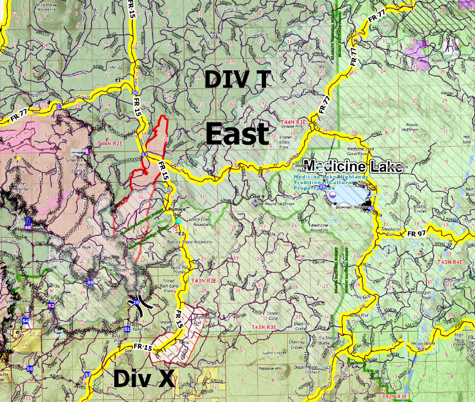
Spot over the line 1.5 miles west of Forest Road 15.
2 Likes
Quite a bit of spread showing on the NE side of this thing on the maps/satellite. A pyrocumulus has also formed over the thing in the last hour or so. Not good!
1 Like
Had a buddy just move a Feller Buncher from there to Happy Camp this morning. Said it didn’t look like much was on the fire.

7 Likes
another view:
http://beta.alertwildfire.org/region/shastamodoc/?camera=Axis-BunchGrassLookout1
helps to zoom in
3 Likes
Ca IMT 10, Type 2, heading to Antelope.
6 Likes
Satellite heat detections were hot this afternoon:
This fire center top and Dixie also blackened some acreage, center in Lassen Ntl. Park (6000+ in the Park)
Caltopo has the topo map heat detections:
https://caltopo.com/map.html#ll=41.55522,-121.71822&z=12&b=t&o=f16a%2Cr&n=1,0.25&a=mba%2Cfire%2Cmodis_mp
EDIT :
Another NASA Fire map after the pyro-cumulus smoke dissipated:
2 Likes
Cam has building column this morning. With latency of additional resource arrival, this looks to blacken some more land:
http://www.alertwildfire.org/shastamodoc/index.html?camera=Axis-BunchGrassLookout2&v=fd40740
Burned quite a bit last night. Refresh between my above post and this morning:
Van Bremmer mtn. RAWS, right on the northern flank: Click on Daily Summary and submit…
https://wrcc.dri.edu/cgi-bin/rawMAIN.pl?caCVAN
Fuel stick = 3.6%
Fuel temp =90
Air Temp= 76
Gusts to 8 out of the west
RH 20% , it never recovered last night reaching a high of 30%
Primed to burn just given this weather, not to mention resource constraints.
However… there is a burn scar out a few miles at the head. Maybe a reprieve if the fuels are reduced in the scar. Zoom out on the caltopo.
I don’t think that camera is aimed at the Antelope today?
I believe it’s aimed at hwy 89/44 junction at Old Station.
The RAMMB satellite heat is showing some hot burning on this fire. It’s got the fuel right now. With the cloud cover and low level smokey conditions the cams aren’t able to see it, I guess. Yesterday was cleaner air. I think I can catch a blip of pyro-cumulous off the Tuscan cam?? (When it points north for a minute. Maybe that’s Dixie too.)
I"ll look at the IAP and maps for changes in resources and sitstat.
At 15:25 Bunch Grass 1 cam is north pointing:
http://www.alertwildfire.org/shastamodoc/index.html?camera=Axis-BunchGrassLookout1&v=fd40740
UPDATE EDIT: Here is the ops map snippet from 9-7-21 14:00 hrs IR :
Jumped the dozer line and seems contingency lines didn’t hold. This is possibly the slop over origin. Could not find IAP’s, just maps.
2 Likes
More Evacs: