CA-KNF-FOX

Last size-up was 170 acres at about 2:45.
On the west, fire had reached 39N70 road, Bluejay Ridge, B spur. IC requested a strike team.

AA cancelled relief for himself, but kept order for relief Bravo in case air improves. Inquiring about availability of a Helco

Smoke rolling in thick in Etna.

Edit: Looking to release Bravo and utilize Helco from Scott Valley helibase at 16:50.

5 Likes

4:55 Helco estimates 300 acres. Has moved quite a bit into Slide Creek. Spotting and some group torching out ahead of the fire. Just ordered a type 2 (H502) to come work on spots to the north.

3 Likes

5:25 p.m.

Helco: Will maybe get 2 more buckets in for each helicopter and then will have to pull the pin. There are multiple spot fires all across Slide Creek well to the north and west of the main fire.

Expects fire to move “a long ways to the west tonight.”

Will make one more pass to get a lat/lon and hover over the spots west of Slide Creek for crew on the road to see where he is, and then head back to base.

6 Likes

Making a substantial run up Slide Creek toward Blue Jay. Pulling resources out of that area. Large column that is leaning over.

2 Likes

Is there a cam on that area?

2 Likes

Nope, no cameras in Scott Valley. It would be really nice if Alert put some up, but power and internet are difficult there.

4 Likes

Just a matter of time before Antelope and Herd Peak can see column. That is if they
weren’t smoked out.

2 Likes

North Ops News and Notes

09/15/2020 1915
CA-KNF Fox Fire: 500 acres brush, timber, 0% contained. Active fire behavior with group torching, wind driven runs and short-range spotting. Structures are threatened with Evacuation Orders and Warnings in effect. Commercial timberlands are threatened and road and trail closures are in effect.

4 Likes

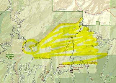
There are mandatory evacuations now for Callahan-Cecillville Rd and warnings for Callahan proper up to Wildcat Creek.

If anyone could help decipher this CodeRED and help with a map, it would be so appreciated. Strike Team is responding to 40N17.

CodeRED:

This is the Siskiyou County Sheriffs Office with an evacuation order west of carter meadows to boulder creek drainage east of boulder creek drainage to forest service road 40n21 north to callahan cecilville rd south to the county line.

This is my attempt:

image

9 Likes

9/16/20. 6:30 a.m.

Fire did not progress much last night. Did not make it to the 17 Road. Night resources spent the shift prepping the road.

Fire has spotted over the top of Blue Jay Ridge.

Briefing at 7.

9/16/20 6:40 a.m.

900 - 1,000 acres

2 Likes

Fox Fire IR Map. 2315 hrs 091520.
761 ac.

20200916_Fox_IR_Map_11x17_Topo.pdf (3.0 MB)

5 Likes

9/16/20 2:45 p.m.

1,700 - 1,800 acres
Fire has reached 40n17 in Slide Creek
Gusts of 15
Group torching and isolated crown runs

4 Likes

1512 acres per last night’s IR flight.

2 Likes

4 posts were merged into an existing topic: KNF/SKU-Fox???

Last report was 143 personnel assigned including three crews and 17 dozers.
17 dozers sounds about right.

2 Likes

1855 acres (+355), 0% contained. Lots of good work by those firefighters yesterday with a south wind on the fire. They are trying to hold it at the 40N17 road. There was a large air show on Blue Jay Ridge, with MAAFS and at least one DC-10 painting and doubling up that flank. Heard AA mention that some of it was burning through. Had helos cycling through the entire day as well to support the ground troops.

1 Like

A post was merged into an existing topic: CA-KNF/SKU-Fox???

1937 acres (+82), 17% contained. The weather has been favorable. Still some work to do, but this one’s looking pretty good.

Link to Ops Map:

https://ftp.nifc.gov/public/incident_specific_data/calif_n/!2020_FEDERAL_Incidents/CA-KNF-007241_Fox/GIS/Products/20200920/Ops_ArchE_Land_Fox_20200920_0504_CAKNF007241.pdf

6 Likes

2188 acres, 43% contained. Looks like the burnout along the 17 road is progressing.