2 posts were merged into an existing topic: CA-KNF-MCKINNEY?
NWS Medford: FIRE WEATHER…430 AM Tuesday …As of 3 am this
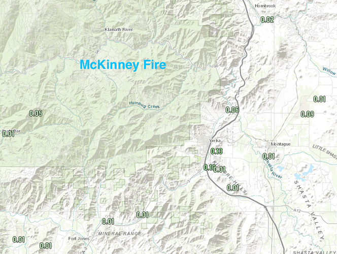
morning, almost 2000 lightning strikes have been recorded since
around 2 pm yesterday (Mon 8/1), and over half of that occurred
since 11 pm last night. Precipitation has been recorded with these
storms, ranging from a quarter of an inch up to half to three
quarters of an inch. However, there were lightning strikes outside
of the precipitation fields/cores. Much of the overnight convection
has merged into an area of rain with embedded thunderstorms and this
will continue into the morning hours before raining itself out.
There will be a relative break in the action late this morning into
the early afternoon before we see another round of what’s likely to
be the last day of significant thunderstorm activity.
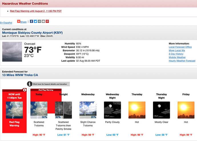
A Red Flag Warning remains in effect until 11 pm tonight for abundant lightning
on dry fuels in these areas. Frequent lightning, gusty outflow
winds, and locally heavy rainfall are all possible with these
thunderstorms and localized severe thunderstorm warning level wind
gusts around 60 mph will be possible.
The low pressure responsible for bringing the moist unstable air
will retreat southwestward today and the Four Corners High will
expand westward Wednesday into Thursday. This will bring the return
of hot temperatures (upper 90s West Side/upper 80s to low 90s East
Side) and bring a more westerly (stable/drier) flow regime to areas
west of the Cascades. In the meantime, another low pressure from the northwest
will move across the Canadian Providences Wednesday into Thursday.
While this will moderate temperatures some, it could bring some
gusty winds to the region, especially east of the Cascades where
guidance suggests gusts of 25 to 35 mph. While it doesn’t look like
humidities will be a concern with these winds, the concern lies with
the potential for any hold over fires.
The remnants of what is currently Tropical Storm Frank in the eastern
Pacific will get swept into the westerlies. How much of this
interaction influences our weather, and to what extent, is still
uncertain, but lingering moisture and instability will result in
isolated thunderstorm potential Thursday and Friday
afternoons/evenings for far eastern and southern portions of the
area.
Looking at the Antelope Yreka cam some increased smoke production today. Atmosphere looks much drier today, fuels are probably becoming more receptive after the precipitation yesterday.https://www.alertwildfire.org/region/shastamodoc/?camera=Axis-AntelopeYreka1
Tanker 162 lifted off Fresno enroute, so need for tankers and smoke production seem to go together.
Intel is on the way for mapping. It will be interesting to see where the heat is and if any growth today. I see that the Yeti was getting very active today.
Looking much better this morning after the last few days of weather influence on the fire.
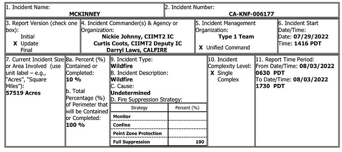
57,519 Acres @ 10% Containment. 2,219 Personnel Assigned
Damage Assessment: A CALFIRE DINS Team is in place. Multiple structures destroyed in the community of Klamath River. Final numbers are pending per DINS report.
12hr. Projected Incident Activity: Perimeter control focus as fire behavior has moderated allowing direct tactics as well as continuing indirect 12 hours: opportunities and contingency lines. Point protection of values at risk operations continue along the Highway 96 corridor near Walker Bridge, Horse Creek and Scott Bar. Fire has progressed to Collins Badly lookout in the south and is backing towards Scott Bar, and Humbug drainage, Deadwood Baldy Peak on the east flank.
Strategic Discussion: Implement direct/indirect line as resources take advantage of fire behavior. Perimeter control direct line has been effective in minimizing acreage burned. Point protection and mop-up around values at risk along Walker Bridge and other communities along Hwy 96. from Hwy 263 junction to Seiad, east towards Yreka, Scott Bar, and Horse Creek on the west. Assist Klamath NF with new ignitions as requested, with CalFIRE.
Critical Resource Needs: 3 DIVS, 10 TFLD, 10 HEQB, 10 FALM, 6-Type 1 Crew, 8-Type 2IA crews, 18-Type 2 crews, 20 Type 3 engines 12 hours: for permitter control for FRA structure protection along Hwy. 96. Crews needed for safely operating in steep, rugged terrain typical of KNF as operations focus on a more direct attack tactic.
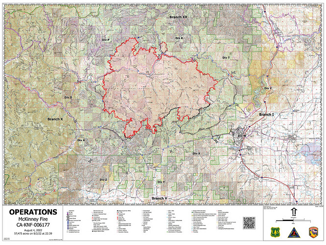
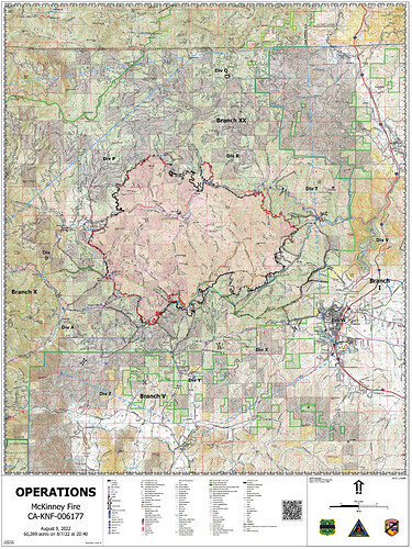
OPS Map 8/4:
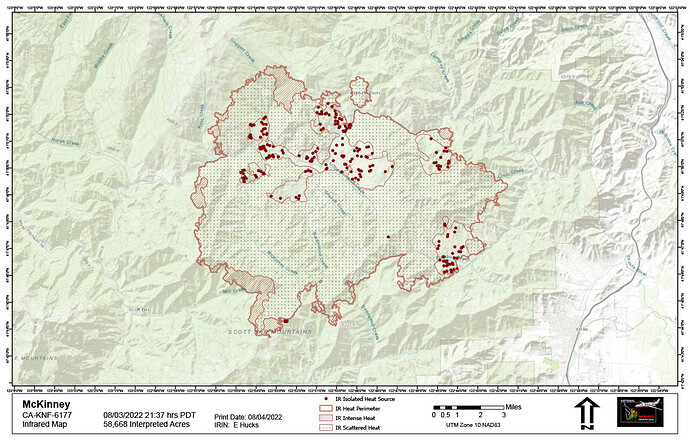
NIROPS IR Flight last night:
A wrapup of our maps and interpretation of existing intel for 8/4/22 for #YetiFire is on The Lookout. McKinney and Yeti Fires – August 4, 2022 – The Lookout
Pretty cool satellite loop showing the smoke for Yeti and McKinney laying in heavy in the canyons all day, only really lifting in late afternoon. COD: Satellite and Radar
And a little pulse of heat in Mill Creek drainage/SW corner of McKinney at the end.
59,636 acres, brush and timber, 10% contained (NOPS 8/5 0700)
From 209 summary 12 hr resource needs:
3 DIVS, 10 TFLD, 10 HEQB, 10 FALM, 4-Type 1 Crew, 6-Type 2IA crews, 12-Type 2 crews, 20 Type 3 engines for perimeter control for FRA structure protection along Hwy 96. Crews needed for safely operating in steep, rugged terrain typical of KNF as operations
focus on a more direct attack tactic.
Most significant change this morning - containment up to 30%.
ONCC: CA-KNF McKinney Fire: 60,044 acres, brush and timber, 30% contained.
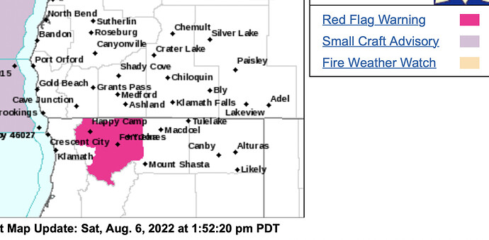
URGENT - FIRE WEATHER MESSAGE
NWS Medford
130 PM Sat Aug 6 2022
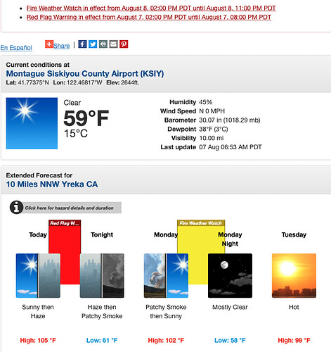
…RED FLAG WARNING IN EFFECT FROM 2 PM TO 8 PM PDT SUNDAY FOR STRONG GUSTY WIND WITH LOW RH
-
Impacts: Strong, gusty wind with low relative humidity and
critically dry vegetation will greatly increase the spread
potential of any new and existing fires. -
Wind: On Sunday, South 10 to 15 mph with gusts up to 30 mph.
On Monday, South 10 to 15 mph with gusts potentially up to
45 mph. -
Humidity: As low as 9 percent.
-
Additional Details: The strongest winds will occur within
the Shasta Valley around Weed and over higher terrain.
New reporting and photos of the Klamath River fish kills are up on The Lookout. Also, satellite severity images, and intel summaries and maps for McKinney and Yeti Fires. the-lookout.org
FIRE WEATHER…300 AM Southerly
winds and humidities in the lower teens will be the main concern
in near future as a low approaches the the region. These
conditions will produce critical fire conditions in sections of
northern California on Sunday with wind gusts up to 30 mph around
Weed and higher terrain. **This includes the **
McKinney Fire, but not the Yeti Complex. Upper level winds are
showing winds right around 30 mph under stronger mixing
conditions. The concern is more elevated on Monday as the winds
appear to be stronger at some sites like Montague and Weed. Some
of these strong winds and lower relative humidities could reach
red flag thresholds in the Cascades and Siskiyous on Monday. The
soundings also look very dry around Monday over some sections of
northern California. This is probably why we aren’t seeing
ensembles produce a massive thunderstorm outbreak across the
region as this low approaches. It is also worth noting that these
soundings also show extreme instability over the McKinney and Yeti
Fires this afternoon, Monday afternoon, and Tuesday afternoon.
Looking good with lots of perimeter black line on the map. 60,839 Acres @ 55% Contained.
Today’s Ops Map resized for mobile/low bandwidth downloading.
AA 112 or was it AA 12 off Fresno enroute. Refuel Redding.

