Remarks:
Transition from Klamath NF Type 3 organization to Unified Command with CIIMT 10 (Mack) and CALFIRE Siskiyou Ranger Unit (Laws) will occur at 0700 on 7/31/22. Accurate resource count will be adjusted as Team transitions today.
Weather Concerns:
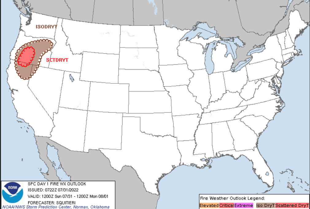
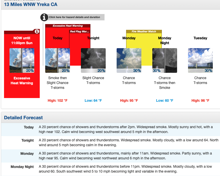
Fire weather watch in effect from Sunday through Monday for abundant lightning on dry fuels. Gusty outflow winds of 30 to 50 mph will be possible near thunderstorm cells. LAL of 3. Above normal temperatures and low relative humidity will increase the drying of the receptive fuel bed. ERC above the 97th percentile and probability of ignition of 100%.
National Weather Service Medford OR
503 AM Sun Jul 31 2022
…Abundant Lightning On Dry Fuels Expected through Monday…
.Heat, instability, and increasing moisture along with multiple
low pressure impulses moving through Monday are expected to bring
scattered thunderstorms and abundant lightning on dry fuels to the
area.
Impacts: Lightning and high fire danger will likely result in
new fire starts. Gusty thunderstorm winds could contribute to
** fire spread.** Despite rainfall, initial attack resources could be
overwhelmed and holdover fires are possible.
Thunderstorms: Today into Monday, an approaching low pressure
system will bring a couple of rounds of scattered thunderstorms.
Rainfall: Today, thunderstorms may begin relatively dry and then
transition to a mix of wet and dry. Monday, thunderstorms are
more likely to produce wetting rainfall. Locally significant
** wetting rainfall will be possible** with some of the thunderstorms,
especially the slower moving ones.
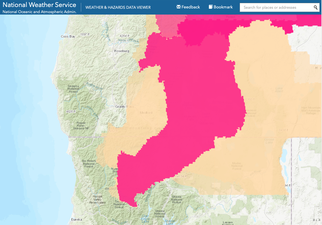
Red Flag Warning
NWS Medford OR
617 AM Mon Aug 1 2022
…Abundant Lightning On Dry Fuels Expected through Tuesday…
.Heat, instability, and increasing moisture along with multiple
low pressure impulses moving through this afternoon/evening and
again Tuesday are expected to bring isolated to scattered
thunderstorms and abundant lightning on dry fuels to the area.
This afternoon and evening the lightning threat will be greatest
from the Cascades eastward as well as over western Siskiyou,
Josephine and western Jackson Counties. On Tuesday, the lightning
threat will be greatest from the Cascades east, Siskiyous south
and into southwestern Jackson County.
…RED FLAG WARNING REMAINS IN EFFECT FROM NOON TODAY TO 11 PM PDT
THIS EVENING FOR ABUNDANT LIGHTNING ON DRY FUELS
Impacts: Lightning and high fire danger will likely result in new
fire starts. Gusty thunderstorm winds could contribute to fire
spread. Despite rainfall, initial attack resources could be
overwhelmed and holdover fires are possible.
Thunderstorms: Isolated to scattered thunderstorms and showers
will develop this afternoon and evening with the best chance of
scattered storms with abundant lightning.
Rainfall: Today and Tuesday, thunderstorms are expected to be a
mix of wet and dry, so locally significant wetting rainfall will
be possible with some of the thunderstorms, especially the
slower moving ones. Lighting may occur outside of the storm cores
where there is little or no rainfall.
Change of IMT: Team 2 (Type 1) will shadow Team 10 (Type 2) today, Team 2 will take the fire and remain in Unified Command with CALFIRE tomorrow at 0700.
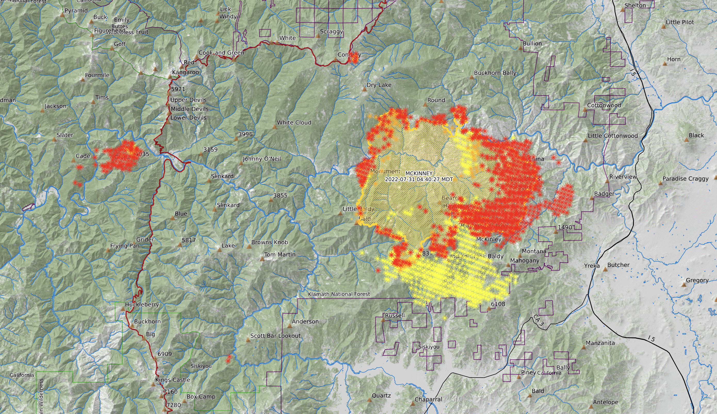
2 Civilian fatalities in their car in a driveway in the community of Klamath River per Siskiyou County Sheriff Jeremiah LaRue. (This is not listed yet on the 209)
Critical Resource Needs: 3-Type 1 Crew, 4-Type 2IA crews, 4-Strike Teams Type 3 engines, 2-Strike Teams Type 6, 7- Dozers, 3-Watertenders, 7-HEQB, 4-TFLD, 2-FALM, 2-FALB
Approximately 100 structures were lost, mostly in the community of Klamath River, CALFIRE DINS Team on order and enroute.
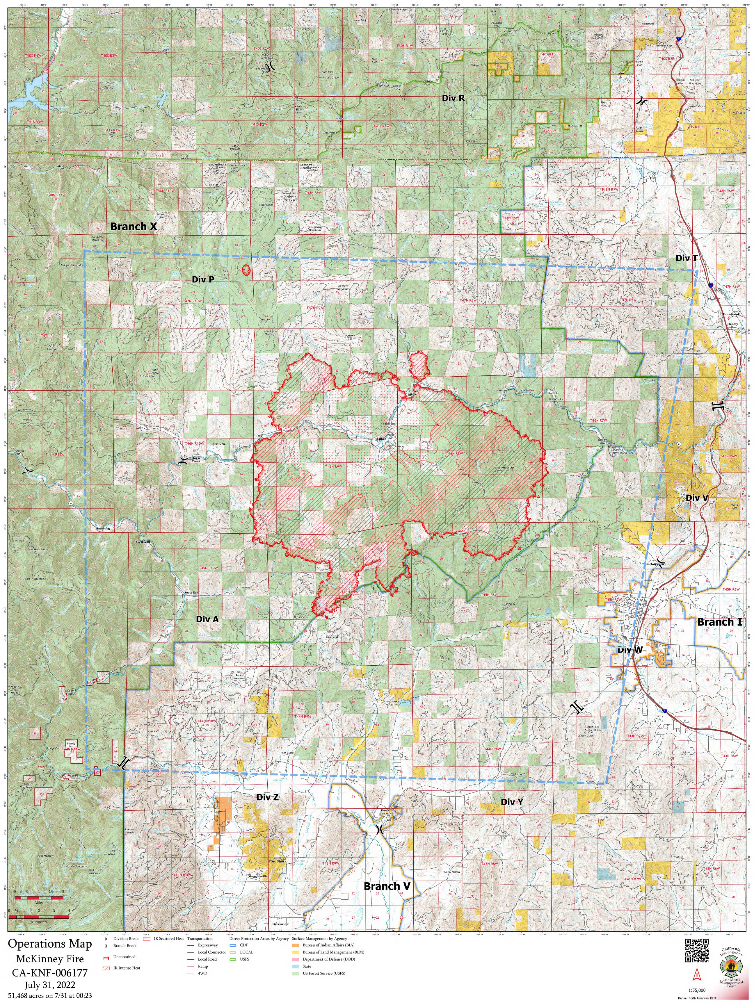
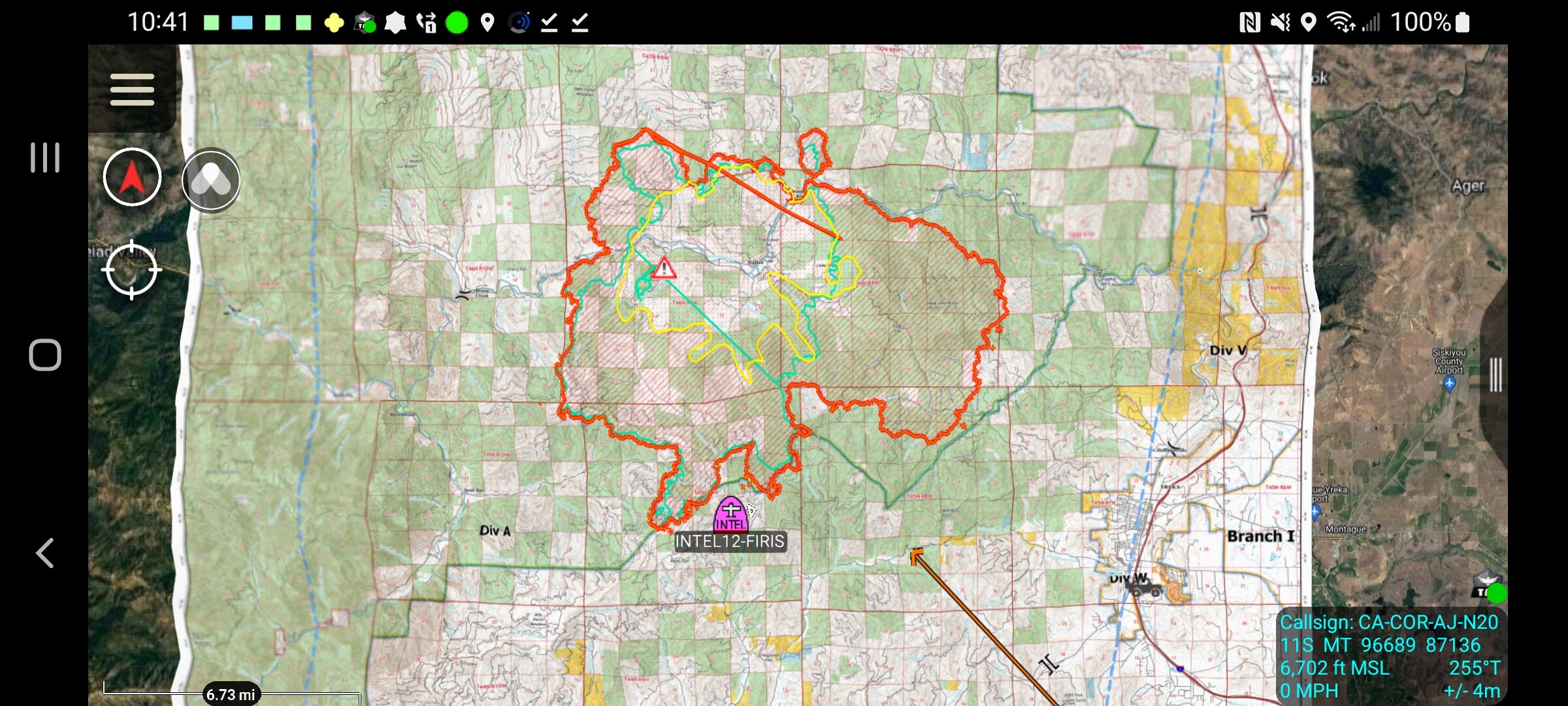
Todays Ops Map (resized for web/mobile downloadability)
I was told yesterday from Team 10 that they were sliding over to Happy Camp today. Not sure if they are zoning the fires or running as separate incident. Will edit once confirmed.