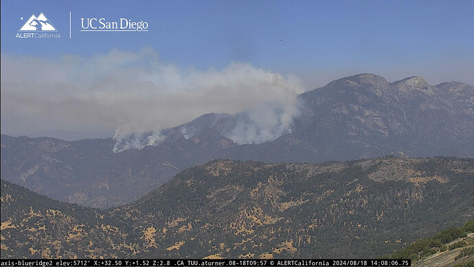
Apologies…OES Region 1.
In '87 I was doing maintenance on the standby generator at Blue Ridge and saw the 2-3 strikes that started ‘Case’. Next day or two I was on it as a Field Observer. Up on top of Case, 1 or 2 Mtn. Home crews had come up from below on the north side cutting handline and had crested the slope, beginning to continue handline down hill on the south side, when someone realized fire had jumped the north-side handline. Had they been successful, ‘Case’ would have been just a few acres.
Early on, Old Timers said, 'You’ll catch it at Cinnamon Gap, and this ridge and that ridge, etc. Sure enough, a couple of weeks later it was caught at Cinnamon Gap and ‘this ridge and that ridge’.
I recall there was a separate fire to the SE of ‘Case’ that was also called “Coffee Pot”.
The contour lines in the area of the current “Coffee Pot” are close together, making for expanded final acreage, I’m guessing.
452 acres. Haven’t found updated maps or an IAP.
IAP.
There’s an airshow with T03, T76, T911 and 3 MAFFs and 3 copters flying the fire. AA15 had to depart for Radio issues back to Fresno.
FKU Maramonte Crews are enroute to TUU. Did the fire slop into State DPA? The crews got cancelled… so maybe not.
As of 7:00 a.m., California Interagency Incident Management Team 5 and CALFIRE, Tulare Unit, have taken command of the Coffee Pot Fire. The fire is a full-suppression fire burning on lands managed by Sequoia and Kings Canyon National Parks and the Bureau of Land Management.
Yesterday, the fire was actively burning down slope in steep, rugged terrain and doubling in size daily.
Today, crews will begin establishing control lines on the south and west flanks around the fire’s perimeter. Hand crews will start at South Fork Road on the west flank and construct a new indirect control line to the north. On the south flank, they will also construct a new indirect control line towards South Fork Road, approximately one mile from the park boundary. The purpose of the new control lines is to keep the fire away from the community of Three Rivers. On the east flank of the fire, firefighters will begin to scout opportunities to create indirect handlines away from the fire’s edge. They are also planning, if needed, a defensive firing operation to protect the Surprise Grove of Giant Sequoia. Firefighters will be aided by water-dropping helicopters.
It’s been burning in CF DPA for days. The BLM in the area is CF DPA.
The miramonte Crews were responding to a reported vegetation fire in the area of Salt Creek FCR & Craig Ranch Rd. The RP was seeing smoke from the Coffee Pot Fire.
Passed three BLM hand crews and one TUU dozer inbound before moon. Several private hire dozers / excavators ordered this morning. Salt Creek and Cinnamon FCR’s need more work after the floods of '22 - '23 to be of good use. The two-track from Case to Oak Grove on Mineral King Rd. needs help, too.
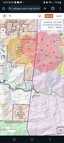
Its burning on Case mountain/milk ranch wilderness study area That’s BLM/CF DPA and burning on NPS land. It’s moving further on to nps land
Here it is clearly marked.
621 acres 0 containment.
Wonder if it’s at the “Gap” yet on the the Milk Ranch. looking at the morning topo map it looks the size of the entire section.
Three private transports sitting empty at the new parking area on Craig Ranch Rd.
If your referring to milk ranch where the old fire look out is the fire is on the opposite side or south side of the East Fork of the Kaweah river.
From NIFC 869 acres still 0%containment
Do you have an IAP?
It’s been linked a few posts above this one, but you can find it here:
Command channel in now CDF Command 1 151.355mhz on Tone 15
Is it really just a Hand Crew and Dozer show?
Seems that way. Listening to the community briefing that was live streamed one engine has been assigned this far. They did mention TUU and Tulare county FD will have units assigned should it get into their areas.

