State ID: CA
3 letter designator: KNP
Fire name: Colony
Location: NE of Colony Peak, ~0.5 mi S of Crystal Cave Road, 36.566, -118.811
Reported acres: 2-4
Rate of spread: moderate per air attack
Report on Conditions: timber
Structure threat:
Resources: H552 for bucket work
Hazards: snags
Weather: weather and webcam view just downslope of fire: Webcam Home - Air (U.S. National Park Service) (nps.gov)
Radio channels:
Scanner link:
Webcam link:
Agency Website:
3 Likes
Changing this to a Q&D thread anticipating new reports. Currently seeing
- Colony: ~0.5 mi S of Crystal Cave Road, 2-4 acres, thick timber
- Paradise: ~1.5 miles NNE of Milk Ranch Peak, 0.5 acres, low on the slope in brush and oak
- Stony/Cabin: Cabin Creek N of Generals Highway, ~2 acres, sparse timber, hard to tell if there are multiple fires or multiple reports of the same one near the park/forest boundary.
3 Likes
Got one on the buck rock camera, I believe it is the stoney.
http://www.alertwildfire.org/sierra/index.html?camera=Axis-BuckRock2&v=fd40740
2 Likes
Heard a copter lift off for Colony about 10 ago.
1 Like
Looks like 2 visible from there. One on the right side of the frame seems to be chewing around in some better fuels.
Buck Rock 2 now picking up both the Stony/Cabin (viewers left) and Colony (viewers right).
Edited: AA overhead with eyes on all three fires. Two Type 2 and one Type 3 helicopters working or enroute, fixed wing on order for the Colony.
2 Likes
There are 9 additional named fires that Wildcad has this morning. Too much traffic for me to split out to whom/resources is on which fire.
All have SQF incident numbers. KNP has no new fires on Wildcad.
Several copters working these. Many reported as low potential.
Jump 62 flew STF for lighting and found a new fire near Fiddletown south of the Caldor fire. Small…low potential. Outside this topic, I know.
3 Likes
The paradise fire is showing heat on caltopo now, no access other than cutting through the brush. There’s some socal Edison infrastructure near potwisha.
Colony with paradise to the south.
3 Likes
AA 15 is over the Colony so, I started a breakout topic for it.
4 Likes
Scanner for KNP fires?
AA is getting 2 Lats up and Heading to Case fire first then, I believe over to the Colony. AA traffic between each tanker is weak.
I thought I saw a Case Fire post but, search yields nothing? Found it but. not finding heat near case mtn.
3 Likes
100% containment on the following fires.
Horse
Peppermint
Knob
All mopped up and in patrol status.
EDIT Update 12:00
Now up to six tankers working between all these incidents. Four S2 tankers and the two LAT’s. Added Two sky cranes in the mix.
6 Likes
They’re going to run the Colony and Paradise as a complex. Approved Type 2 IMT (RM Black) on order with an unknown in brief date/time
Colony: 71 acres 0% contained
Paradise: 36 acres 0% contained
We will monitor prior to combining into one thread when the complex is official…
4 Likes
From South Ops:
KNP Complex, Vegetation Fire, Tulare County, Update Castle Rocks, east of Hwy 198 Federal DPA, FRA, Sequoia Kings Canyon National Park · 350 acres (+100 acres), grass and brush, 0% contained (+0% containment) · Active fire behavior with flanking, backing and uphill runs · Evacuation orders and warnings in place · Limited access due to steep and rugged terrain · Complex is comprised of Paradise and Colony incidents · Type 2 team on order
2 Likes
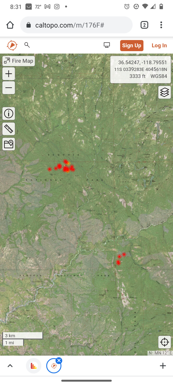
Caltopo for the Complex on the KNP
3 Likes
I don’t have much on this incident. Near the Pinewood & Round Mdw community.
Hopefully the road to this area is decent.
AA15 is up over this fire assessing resource needs. Can update his requests later.
It started yesterday with the lighting that passed through. It seems from caltopo that it has grown from yesterdays small start. Estimate currently in the 10’s of acres. Colony Peak is the major feature at 6000’, thus the name. 11:15 9/10 was the first resource assigned. Chimney Rock is on the Wildcad descriptive location. I don’t see that feature.
Scroll down, south and there is another start near Buckeye Flat Campground.
Paradise incident.
3 Likes
Hello, Colony, Paradise and Cabin Creek (or just Cabin) are CA-KNP. Not sure about the others.
2 Likes
SQF was working them on Ch.4 yesterday. Unified command most likely. Hear resources responding this morning. KNP copter was assisting yesterday.
Two LATS from AA410 requested.
Do you hear Park Traffic on their channel on these today? I don’t have them in my scan.
I can’t find inc#'s for KNP on these… seems that Wildcad is not updating.
They are in the Park. I know I heard resources from walkers get reassigned to these incidents.
2 Likes
All Q&D for the Paradise, Colony, and any lightning holdovers managed by the team within the complex will be placed here.
Thank you,
FJ
2 Likes
I can no longer hear any KNP command traffic given the repeater is over the horizon for me.
Did pickup a lot of tanker traffic on AirTactic yesterday but, nothing so far this morning. High chance the AA frequency has changed. I don’t find an IAP nor Map on the incident specific FTP site.
Someone else find some documents or intel?
1 Like