
Daily brief.
1 Like
Smoked in all day, no flights or radio traffic pertaining to flights. Branch 2 & 3 little fire activity, skunking around in the burn a little. Plumbing a hose lay from Milk Ranch at least to 198 for sure. Tractors sitting, starting to scout for busy work, I imagine because they have them way up Mineral King and it’s a nightmare hauling equipment in and out. Pretty much all Hand crew country. Terrain is geographically about impossible to construct beneficial dozer line pertaining to what the fire is doing and where it’s at. That’s about it
13 Likes
Div. C have holding issues and requesting type 1 copter support.
I believe that will require AA to be up. Going to be some response delay
to asses the smoke conditions.
4 Likes
Updated Evacuation Notice : Sheriff Boudreaux has issued EVACUATION WARNINGS for the communities of Eshom and Heartland Camp, including Eshom Valley Drive, from Fresno County Line, South to Tarbell Pocket on Eshom Valley Drive, and North Mountain Road, 468 North to the County line. The warning includes all structures, side roads, associated roads, and forest service roads, due to the KNP Complex Fire.
Evacuation warnings are voluntary. Community members are strongly encouraged to prepare to evacuate if it becomes necessary. If individuals feel they need more time, please consider leaving the area now.
The temporary evacuation point, where you may find information and assistance is at the Woodlake Community Center at 145 N. Magnolia. Individuals who may need assistance evacuating may call 2-1-1. Older individuals (60+) who need assistance with evacuation or information may call the senior hotline at 1-800-321-2462.
4 Likes
AA15 and AA430 both went up this morning and stated that Branch 2 & 3 are too smokey to use aircraft. A copter tried to work in Div.C but unable to help due to smoke.
EDIT UPDATE 15:00;
AA430 departed as there is no visibility for any aircraft on this incident.
I can see why on the RAMMB satellite page… KNP winds are slack with a sight east push. Windy has a stronger upper level winds out of the west pulling the smoke away from the fire ground. Looking at Ventusky for that intel.
Set for upper level winds at a mile up. Set wind speed altitude at left menu:
3 Likes
Hear AA say today fire is just skunking around in most places. Not too much activity. Seems to be hung up on ridges. Weather is on a downward cooling trend for awhile. Hopefully crews are able to get in and do some cutting and air clears up for more drops. Dozers on the far, way out out doing contingency. That’s about it
5 Likes
I don’t know what time that report was. But it does not accurately describe what happened today. There were several good runs from the fire today and it moved significantly closer to the North Fork of the Kaweah River. When I drove out tonight after my shift change the fire was very active on the ridge above the River and had progressed today more than it has in 3 days.
4 Likes
Copy that, just reporting from my vantage point and ears.
4 Likes
Not a problem at all. Just saying what I saw today. We have been building contingency lines from The North Fork of the Kaweah River North for Cal Fire and are now on the east side of Hartland to protect the communities. Have been driving it every day since Sunday and the fire was more active today.
10 Likes
Spot fire over Mineral King Road, 500’ below the road and one acre in size. Aircraft not able to fly.
7 Likes
Thats a pretty long road, anything more specific?
1 Like
And most of the lower part is not friendly country
5 Likes
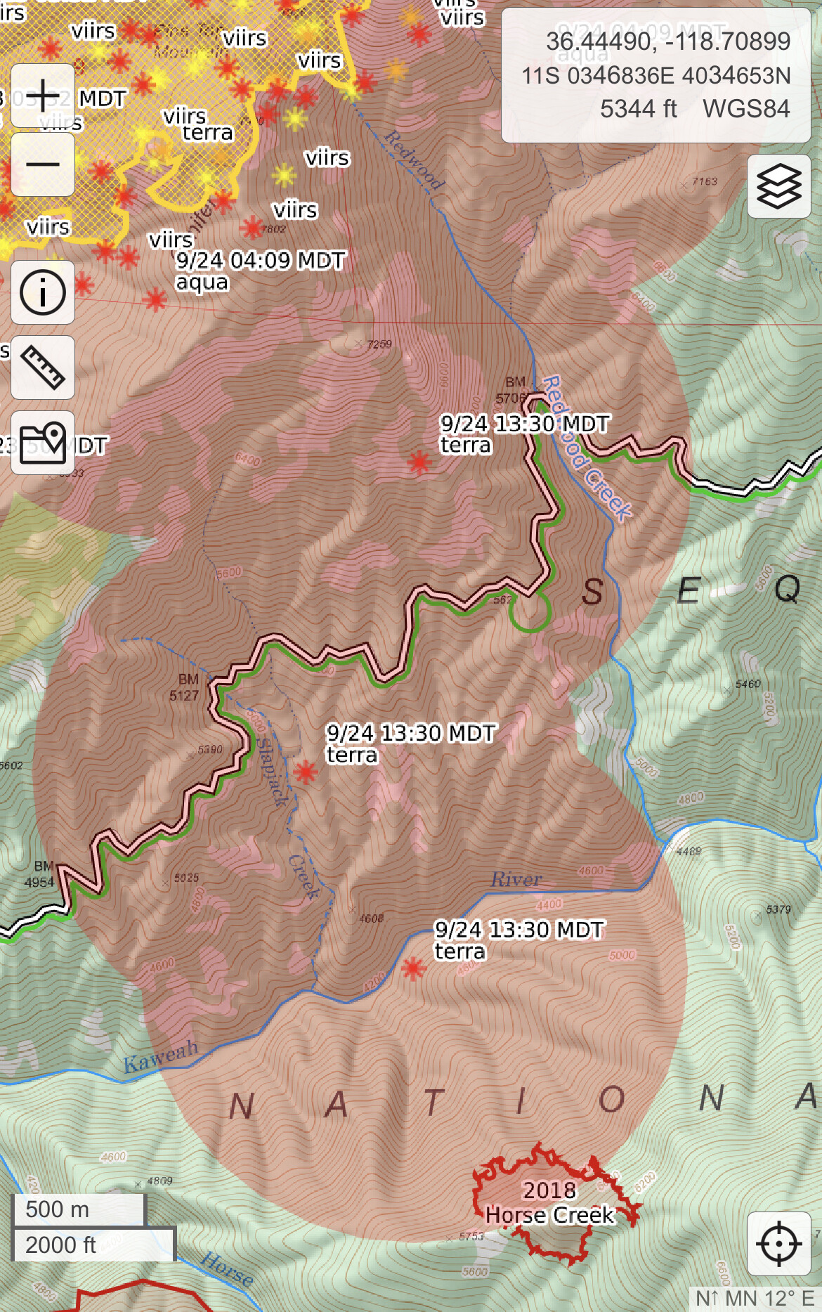
If the caltopo IR is to be believed, it’s pretty far East up the road, by Slapjack and Redwood Creeks. Anyone have more info?
3 Likes
I saw that too along redwood creek down to the south fork. Could just be heat in the column though - hoping to get more details on the first report? is that on the ground/first hand/ radio info @phoenix559 ?
2 Likes
There’s a ton of beetle trees in that area. I really hope it’s not a spot.
2 Likes
To the south, it will run into the Castle fire burn from last year. All kinds of road improvements done with all sorts of new dozer roads put in.But to the east and west between KNP and Castle, who knows
4 Likes
It was on Divison Charlie via the radio.
3 Likes