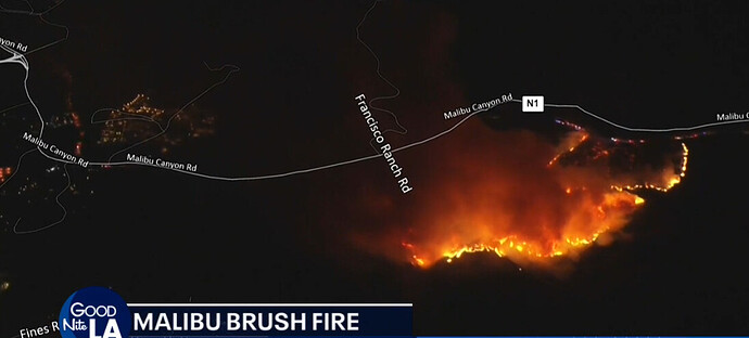
State ID: CA
3 letter designator: LAC
Fire name: Franklin
Location: Malibu Canyon Road; 1/2 mile north of Francisco Ranch; Malibu, CA
Reported acres: 10
Rate of spread: rapid
Report on Conditions: fire burning in medium to heavy brush, rapid rate of spread under a Santa Ana condition with spotting across the canyon towards Piuma Road: Potential for 500 acres.
Structure threat: are threatened
Resources: ST 1102A, 2nd alarm LA County Fire.
Hazards: santa ana winds; steep terrain
Weather:
Radio channels:
Scanner link: LA County Fire V-1
Webcam link: Topanga Peak 1
Saddle Peak 2
Castro Peak 2
69 Bravo Fixed West
Agency Website:
CP is Station 125, Asking for a 2nd alarm, Fire is in the FRA with threat to the SRA, IC asking for a large amount of air resources.
IC asking for a 3rd alarm, Staging at Mulholland and Las Virgenes.
Fire is growing rapidly. Upside: the fire is within a few miles of the coast, locals know the pre plan with this scenario very well.
Fire is impacting Serra retreat now. Cross Creek Road x Palm Canyon Lane.
Strike Team 1102A is assigned to structure protection at the retreat.
HelCo advising fire at about 120 acres. IC placing an order for fixed wing tankers for the morning.
HelCo advising winds are to strong for copters and terrain is to steep for ground crews to catch the spot fire.
One spot on A and one spot on Zulu. Zulu priority…
20-30 min before active threat to Pepperdine Univ. Malibu Cyn road impacted. Resources will start to have coming in from the coast.
Mapped at 314 acres by FIRIS.
LASD going to have to start addressing evacs near and around Pepperdine area.
Div B requesting 3 Imed ST for structure defence near Pepperdine Univ. Univ to shelter in place as of now
VNC Resources:
XVE 1551A & 9325C
C11&12
WT
9325G
CPT4
Fire info from Helco and TV confirm fire is now burning from South to North, temporary sparing DT Malibu for now.
3 posts were split to a new topic: CA-LAC-Franklin???
Intel ship now stating 858 acres


