
thank you for your work
2 Likes
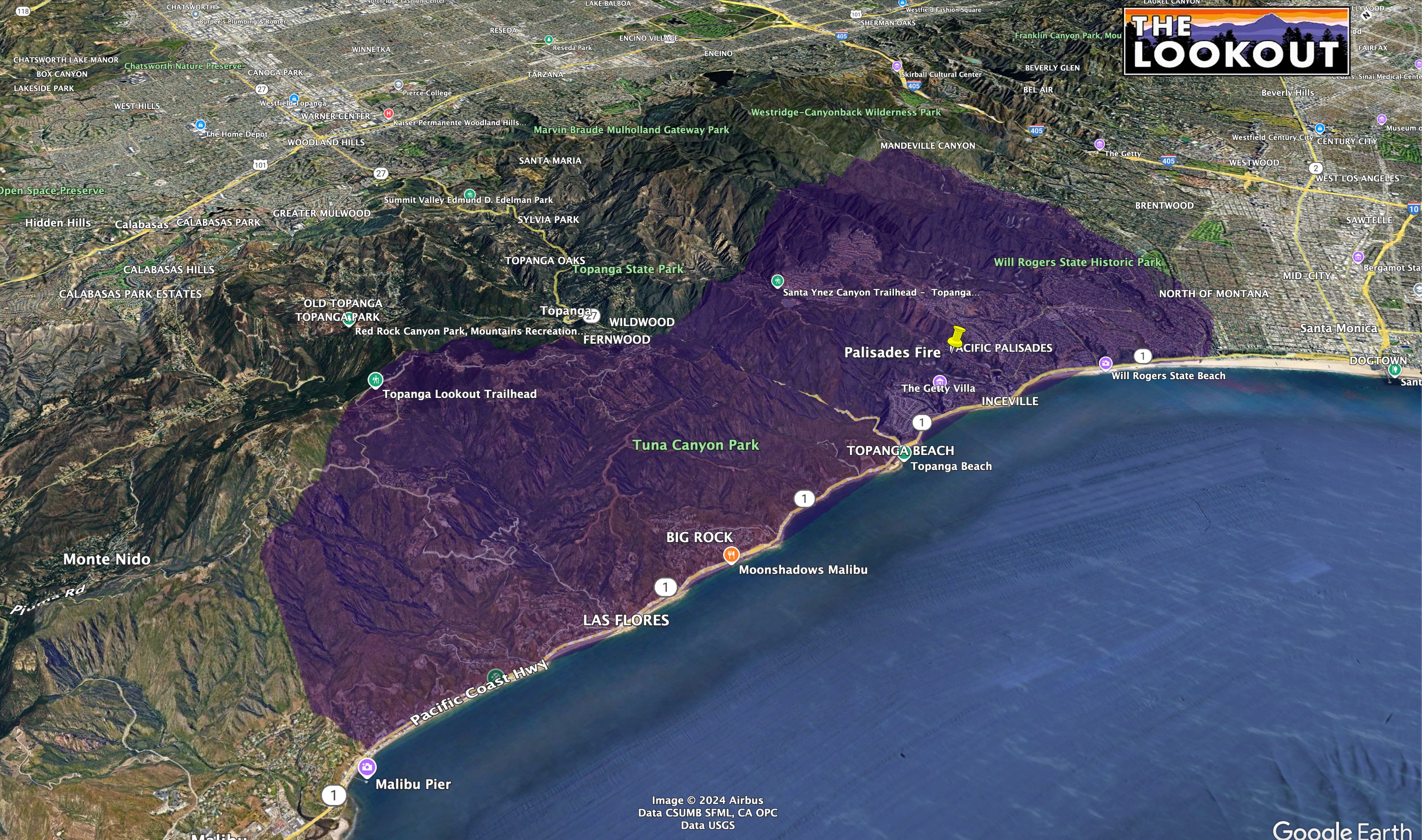
XLE 1281A: MTB STEN, SFS STEN-T, PAS 34, MTB 55, DNY 621, DNY 63 and SFS 822.
3 Likes
Do we have a move up and cover thread?
1 Like
Not for 2025 yet
3 Likes
RVC has 2 Alpha’s code 3 leaving now. To the Eaton Fire. 10 engines all SCH. A.
2 Likes
Very few resources to East, cresting onto old Ranch road. Scanner got very quiet too.
1 Like
OES alpha s/t from San Diego will be enroute in about an hour and be there at 0700
3 Likes
When can they fly again?
1 Like
Depends on the wind.
2 Likes
I don’t know why a chopper couldn’t attack this San remo fire line. But whatever crews are up there are doing the lord’s work. It hasn’t moved much in 2 hours. You can see them chase the spotting
2 Likes
Between the heavy winds, and heavy smoke, they will fly when reasonable. Remember, night air ops is still on the new side, and extremely complicated.
7 Likes
I think I was wrong - I think based on what i’m seeing on the cameras, it might well well be over 10k acres when the sun rises, possibly much more…
also that 10k homes at risk number mentioned early on might unfortunately be an underestimate as well
we’ll see what the data says
1 Like
Palisades extended air frequencies assigned for today:
Air Tactics FM: 166.6125
Air Ground: CDF A/G6 159.285 t192.8
Victor TFR: 123.175
Victor: 118.575
TOLC: 123.025
Additionally, vtacs 13, 14, vfires 24, 25, 27, cdf tacs 27, 28 assigned
5 Likes
From first hand accounts the loss of structures will be staggering. The $ value will probably be the most ever lost in a fire.
5 Likes
Helco and operations sounds like they have some opportunities on the eastern flank to go to work with the helicopters , 20 acre slop over in the same area (old ranch road ) said 20 acres will back down the canyon
2 Likes
AA just checked in over the incident ordering a lead plane.
4 Likes
5,000 plus acres. 1k Homes lost per. LA County. Live press brief.
5 Likes
You always have strikes…
3 Likes
Its part of how the state identifies resources in the states mutual aid system. The state is divided into 6 geographic regions and then each region is subdivided in multiple areas (a group of cities/departments). That being said here is a quick break down;
The 1st 3 letters identify the Department/county (if it starts with an X it’s a Strike Team consisting of mixed Departments)
The 1st number represents the states mutual aid region they are from.
The 2 nd number represents what area they are from in that region.
The last 2 numbers represent a block of numbers that area is assigned for spefic Departments in that area.
That’s it in a nut shell!
6 Likes