Napa County Fair Grounds in Calistoga also known as the Calistoga Fairgrounds
Thank you.
Heard reports from division PP about people returning to their homes. Apparently the evacs being lifted may have been a mistake?
Did anyone else hear that?
Some areas have lifted, most have not.
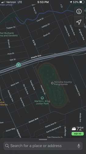
Sonoma co fairgrounds, unless it changed from this morning after we left it. Same icp as Tubbs fire few yrs back.
I think that is just a staging area currently.
Sonoma County Fairgrounds is a ICP, looking at it right now.
Yes.
Sonoma Co. Fairgrounds is ICP. (I was there today, too)
Shut down the Calistoga base camp and moved it to Sonoma County fair grounds when Calistoga was evacuated last night.
Any word on the DIV SS. Any concerns of the mark west springs drainage. With the way the tubs went that’s a funnel right back down. I have elderly family there that was evacuated and it’s pretty far from the fires edge
It’s still a ways from mark west, I believe they have line punched across the north end of the fire hopefully that holds if the prevailing winds develop tomorrow afternoon
The island that was making a small run in Div ZZ / SS was heading to the Northwest a little. Still quite a ways from Mark West area though.
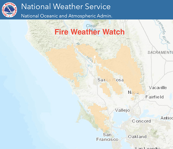
Areas of the Glass Fire are under a Fire Weather Watch by the National Weather Service due to increased temperatures today through Friday. A good weather app I use on the go is the NOAA Weather app which has filters that show all critical fire weather.
I heard 1-2 mentions in chatter yesterday about Glass reaching the Hennessey Fire scar but it was mere mentions.
What are your thoughts?
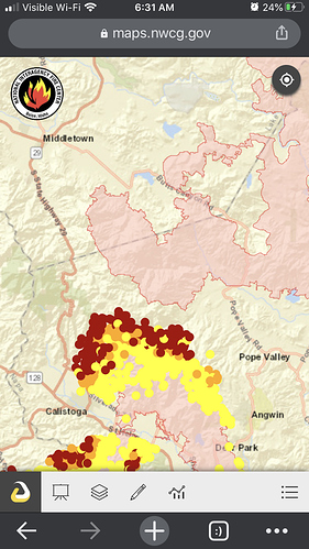
It looks like their is a good chance the northeast flank of the Glass will hit the Hennessy scar in the area of Aetna Springs as the fire continues to progress along the eastern flank of Mt. St Helena.
Though the forecast does call for a moderate north wind today which might limit the fire spread on Mt. St Helena.
Yeah, tomorrow NWS predicts winds from NW gusting up to 25 MPH - We’ll be in Fire Weather Watch starting at 1 PM until 6 PM Friday. This morning they will decide if they want to push it up to a Red Flag. Which would be the first time the fire sees NW winds… another long 48 hours ahead.
Yes I would assume that securing rattlesnake ridge to the palisades will be a main priority ahead of the winds.
NWS - SF 5:21am Glass Fire: Will not upgrade Fire Weather Watches to a Red Flag Warning yet. Will let the day shift make the final call after the morning fire weather conference call.
Fire Weather Watch 1 pm Thursday through Friday 6 pm. Yet the fire remains active near Calistoga. Conditions shouldn`t change too much for today. By midday Thursday models bring some increasing Northwest (onshore) winds, but with lowering humidity values. Northwest winds to increase by Thursday evening with gusts 25-30 mph out of the northwest which would be the first time the Glass Fire feels the effects of gusty northwest winds. Any open or unsecured line in the East Zone would be adversely impacted as well as lingering heat near the zone break and Div KK. Conditions to remain hot, dry and breezy through. Friday with persistent WNW winds with highs still in the 90s. Finally some cooling this weekend.
After the heat ends the next item to keep an eye on will be the remnants of current Tropical Storm Marie. Operational models and ensembles continue to show some moisture advecting toward CA as a trough digs into the PacNW. A few of the models even generate some QPF (rain) over NorCal including parts of the Bay Area. Obviously impacts would big, confidence is low
.FIRE WEATHER…as of 9:15 AM PDT Wednesday…Critical fire
weather conditions are expected to develop over portions of the
district Wednesday and Thursday due to hot, dry and breezy
conditions.
A shallow marine layer developed overnight bringing much needed
relief to lower elevations of the district. However, conditions
above 1,000 feet still remain mild and dry this morning. Satellite
imagery still shows some heat associated with the Glass Fire.
Specifically the hills above the community of Calistoga.
The Fire Weather Watch has bee upgraded to a Red Flag Warning for **
** the following areas:
Glass Fire: Red Flag Warning 1 pm Thursday through Friday 6 pm.
Yet the fire remains active near Calistoga. Conditions shouldn`t
change too much for today. By midday Thursday models bring some
increasing Northwest (onshore) winds, but with lowering humidity
values. Northwest winds to increase by Thursday evening with gusts
25-30 mph out of the northwest which would be the first time the
Glass Fire feels the effects of gusty northwest winds. Any open or
unsecured line in the East Zone would be adversely impacted as
well as lingering heat near the zone break and Div KK. Conditions
to remain hot, dry and breezy through Friday with persistent WNW
winds with highs still in the 90s. Finally some cooling this
weekend.
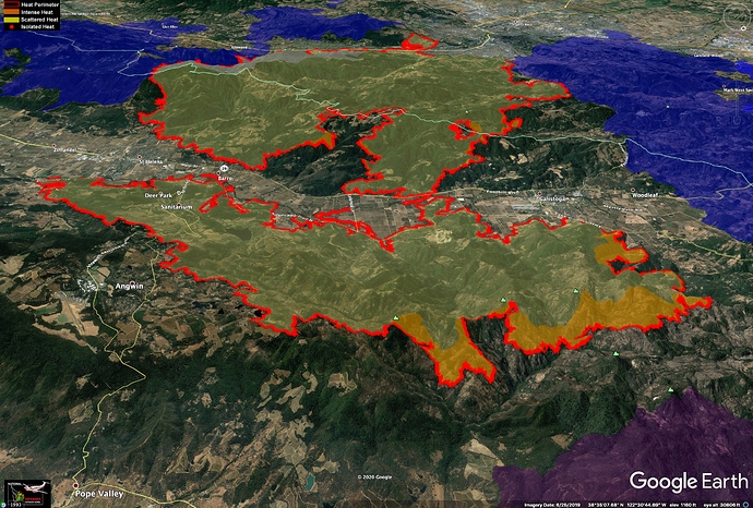
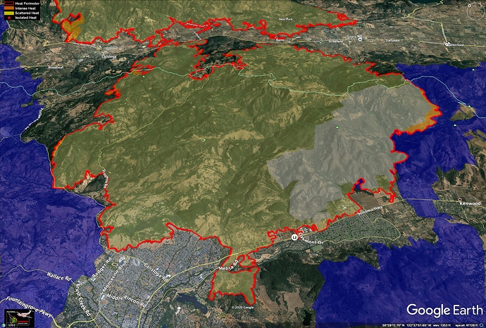
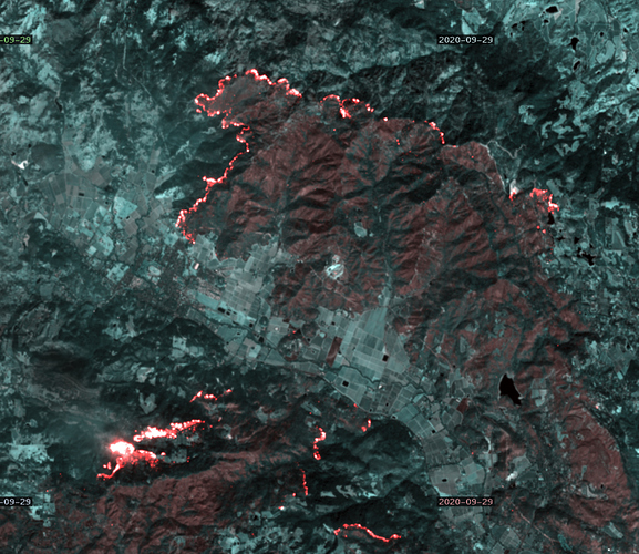
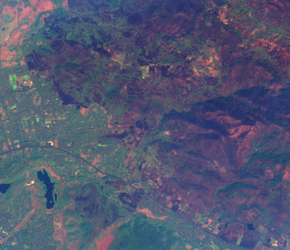
False-color Sentinel imagery from Tue 9/29:
better smoke penetration
better color differentiatation
These are false-color images, using IR bands to provide better smoke penetration and better visualization of vegetation than a true-color image. Heat sources are also false-color; the actual fire is not as visually intense as it appears in these images.
