State ID:CA
3 letter designator:LNU
Fire name:GLASS
Location: Crystal Springs Rd east of St. Helena
Reported acres:30+
Rate of spread:Rapid
Report on Conditions:
Structure threat:Mandatory Evacs
Resources:
Hazards:
Weather:Red Flag
Radio channels:
Scanner link: https://m.broadcastify.com/listen/feed/865
Webcam link:
Agency Website:
The fire has crossed Silverado Trail to the west near Crystal Springs rd, got some of vineyard out in front
1 Like
C1404 has assumed Glass IC. Placed an additional order for 4 dozers, 4 crews, 2 STEN any type immediate need. Early up for SAAB and Boggs 0800 to the fire.
Strike Team 2398c (pre-positioned for red flag) was dispatched
2 Likes
http://www.alertwildfire.org/northbay/index.html?camera=Axis-Atlas&v=81e004f
Stone Ridge Drive (PG503) Severity:35
| TIME | RH | WIND | TEMP | FUEL |
|---|---|---|---|---|
| 05:50AM | 30% | NNW5G19mph | 74 | |
| 04:50AM | 33% | NNW8G19mph | 74 | |
| 03:50AM | 34% | NNW8G24mph | 74 | |
| 02:50AM | 37% | NNW8G21mph | 74 |
1 Like
2 Likes
5 Type 1 copters, 100 acres per Glass AA.
2 Likes
As long as the fire is moving to the west or to the south, they should be able to pick it up. Not much to burn other then a few hilltops before it runs into vineyards. Now if it starts to move east and away from the valley floor then that’s a whole different story and Deer Park/Angwin would be in a bad spot.
2 Likes
800 acres now
1 Like
North Bay IMT (Tyoe3) activated.
IC just put in a request for more units. Radio traffic was scratchy but it sounded like an additional request for 4 ST, total of 10. Can anyone else confirm this?
Request was for 4 more additional Golf, immediate need
3 Likes
Thanks for the info
Based on early reports that the fireline initiated at the 200 block of North Fork Crystal Springs Rd and later crossed Silverado Trail N and additionally released livestream footage showed fireline effectively swallowing the valley bowl surrounding Zakin Family Estate as seen from Highway 128 off of Madrigal Family Winery-- I’ve made a rough map with some certainty of where the fireline stands. This would effectively show the fire is much closer to between 800 and1,000 acres rather than the 20 to 100 reported all morning.
I am not an official and this makeshift fire map should be taken with a grain of salt. However, I am quite certain this is the burn area as of 6:30 AM.
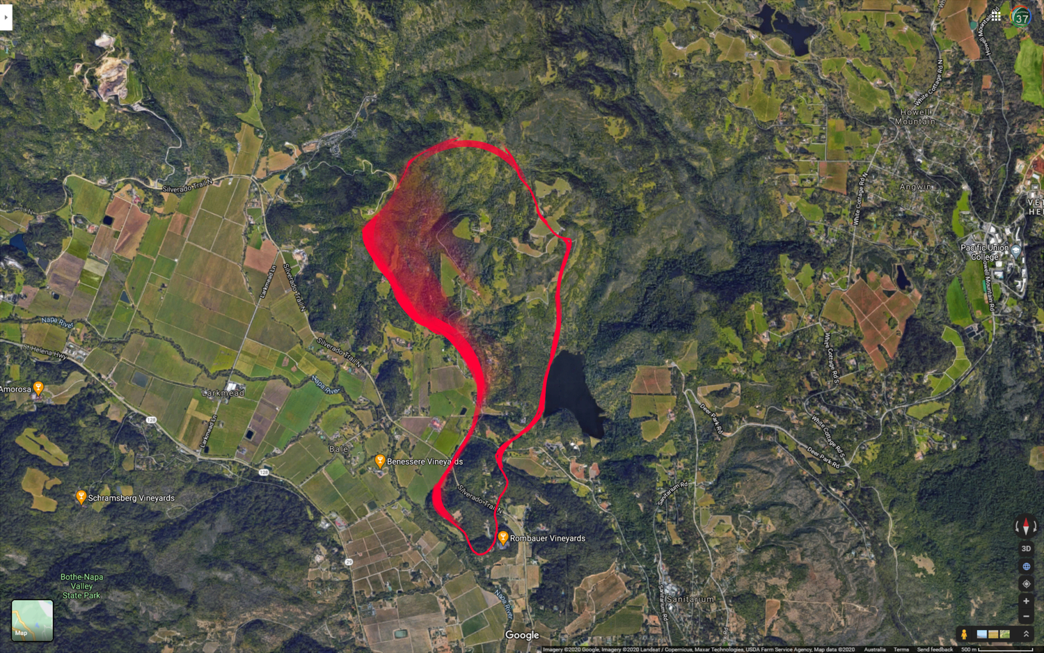
10 Likes
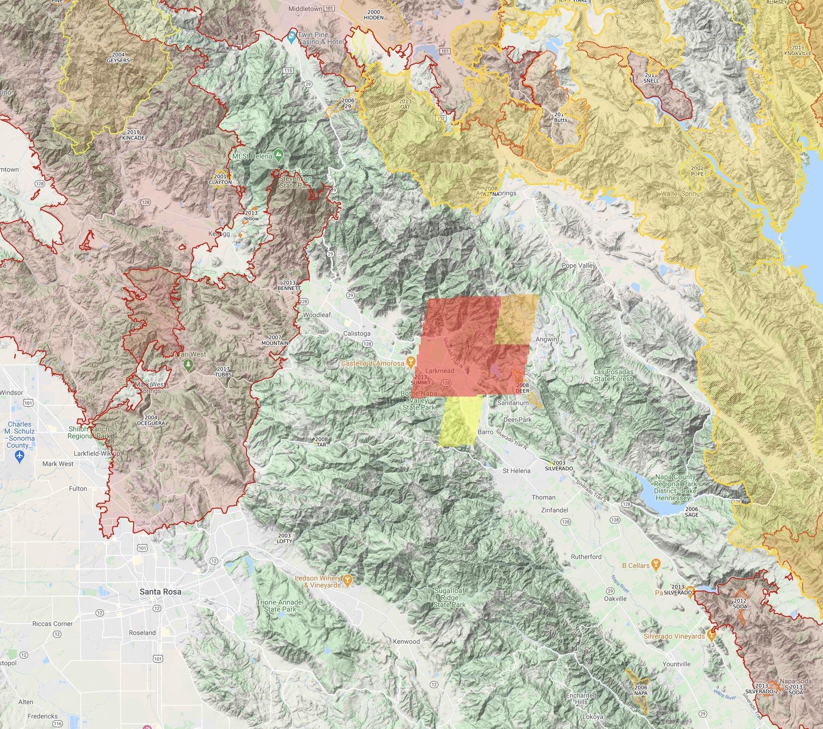
GOES17 fire detection giving idea of fire location, with area fire history. Yellow to the east is Hennessy.
7 Likes
Where can you access the livestream footage?
From St. Helena Cam looking South Now, this will get interesting later this morning when the winds mix down to the valleys:

3 Likes
Current evacuation orders:
- College Avenue at Howell Mountain Road to White Cottage Road
- All of Feisen Drive, all roads of West of College Drive and Feisen Drive
- All of Lommel Rode
- All of the community of Deer Park
- All of Crystal Springs and North Fork Crystal Springs Roads
- Deer Park Road to Crestmont Drive
- Deer Park Road to Crystal Springs Road
- Deer Park Road to Devils Elbow
- Larkmead Lane to Deer Park Road
- Silverado Trail
County officials said the community of Angwin is under an evacuation warning.
An evacuation center has been set up at Crosswalk Community Church, 2590 First Street in Napa.
3 Likes
ST XCC 2026A Enroute from CoCo County
1 Like