CA-LNU-Walbridge (13-4)

Updated with MODIS satellite data.

1 Like

Latest evacs…

https://sonomacounty.maps.arcgis.com/apps/webappviewer/index.html?id=69a0e54e9e2b48c086d122027b21c961

2 Likes

Yes, nothing new overnight.

I saw potential 15-20 mph winds this afternoon out of the West. That would push it closer to Healdsburg and Windsor if that is the case.

1 Like

Here’s the VIIRS link > select VIIRS, then “Current” to download a .kml file to open in Google Earth

https://fsapps.nwcg.gov/googleearth.php?sensor=viirs&extent=conus

Another strong push to the SE last night.

3 Likes

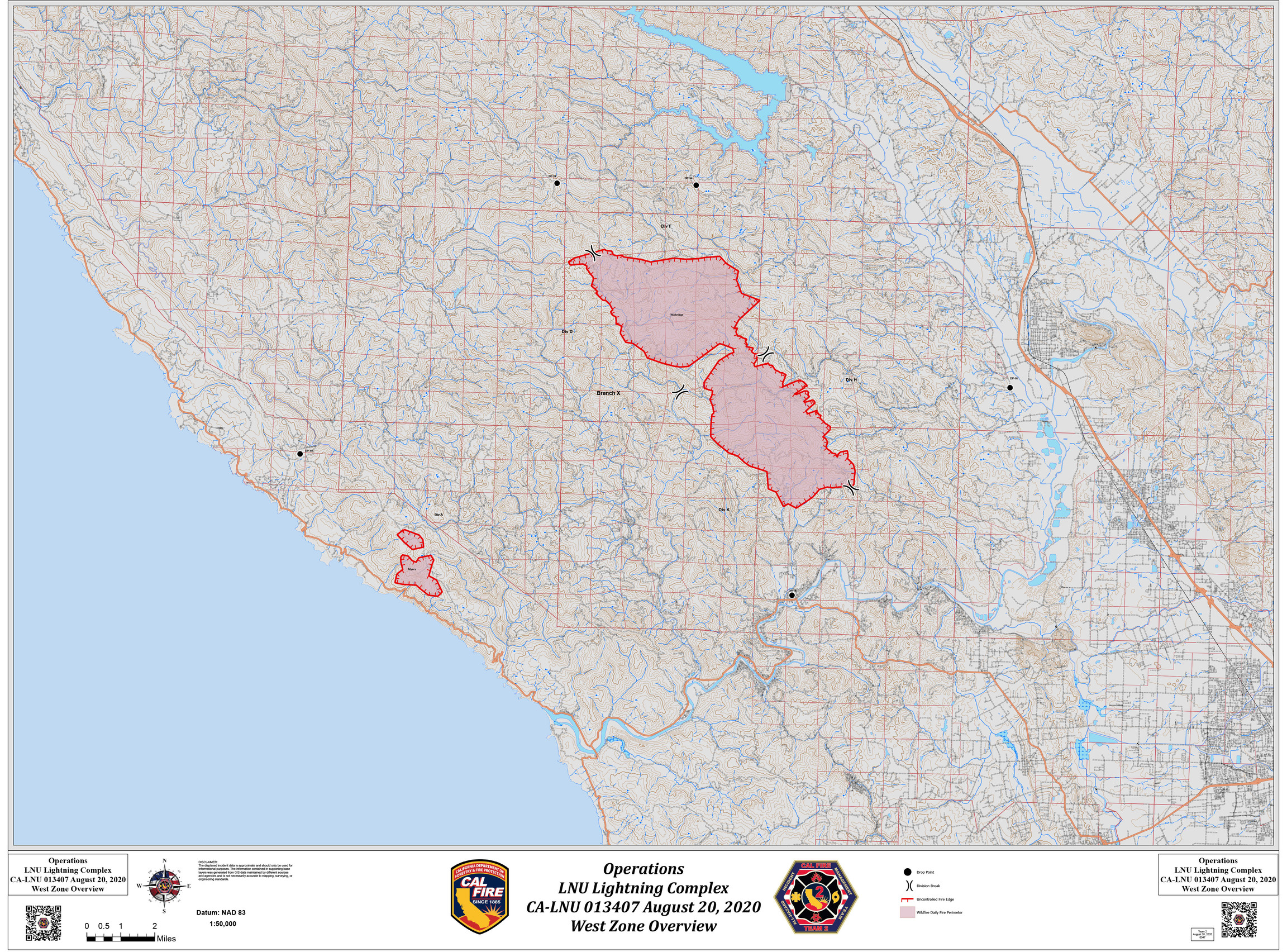
Thursday 8/20 OPS Map. Looking at Google Earth the fire is approx 3 miles from Healdsburg and 5 miles from Westside of Windsor as of last night.

3 Likes

Hopefully if the winds aren’t to strong they can hold it at the river or catch it in the flats before it hits town.

Sounds like aircraft is not going to be very effective. They will work on point protection for structures where able in the Mill Creek Rd area.

1 Like

Was there a change in communication channels this morning? 8/20/20? I heard they are on Comms 2… I know they were on cmd6.

Yes, the entire LNU Complex shifted to different channels this morning.

NIFC CMD-2 for the west
NIFC CMD-8 for the north
NIFC CMD-12 for the south

5 Likes

Does anyone have a copy of the ops plan?

Looks like Meyers is lighting back up on the air quality index. This wind is bad news for the River communities.

1 Like

Per Complex AA the Meyers fire is looking really good. They are optimistic that they can get some containment on it today.

3 Likes

Per AA, 200 Yards North of Mt. Jackson, Backing down a canyon with no wind on it, Still moving south towards Rio Nido/Guernville

1 Like

4 posts were merged into an existing topic: CA-LNU-WallBridge?? (13-4)

Fire directly below the mt Jackson cam

http://www.alertwildfire.org/northbay/index.html?camera=Axis-Jackson&v=81e002f

Some intel for those evacuated on the Westside of Healdsburg and Healdsburg propper. Based on this morning’s fire perimeter data, the fire is approximately 2.8 miles due west of Hwy 101 in Healdsburg, still up in the hills above Westside Rd.

3 Likes

Friday 8-21 Ops Map:

1 Like

UPDATED - Per Sonoma County Sheriff @ 1112 Friday 8/21

Mandatory Evacuation Order has been expanded to include all residents in the follow area(s):

Map Grid 4B1 Mandatory Evacuation
All areas south of River Rd. from Martinelli Rd. to the intersection of River Rd at Trenton Rd.
West of Covey Rd.
North of Front St. / Hwy. 116
East of Martinelli Rd.

Map Grid 2A3 Mandatory Evacuation
North of Stewarts Point Skaggs Springs Road to the eastern edge of Lake Sonoma
Everything west of the eastern edge of Lake Sonoma to the western boundary
that runs north along the ridge line from the intersection of Stewarts Point Skaggs Springs Rd @ Old Stewarts Point Skaggs Springs Road to the interception of Rockpile Road @ Cooley Ranch Road north to the Mendocino County Line.

2A3 This is a very rural area with no clear defining boundaries

1 Like