
This is now the Wall Bridge Fire and the fire near Fort Ross is the Meyers Fire.
2 Likes
Added evacuation warnings…
1F1 Warning
All areas east of Bohemian Hwy.
North of Graton Rd. and Harrison Grade Rd.
West of Harrison Grade Rd., Green Valley Rd., and Hwy. 116
South of the Russian River
1F2 Warning
All areas south of the Russian River
East and North of Hwy. 116 (Pocket Canyon)
West of Martinelli Rd.
4A1 Warning
All areas East of the Russian River
North of River Rd.
West of Trenton Healdsburg Rd. and Eastside Rd.
South of the area between the western dead end of Windsor River Rd. and the Russian River
Be advised if you live in this area you may be ordered to evacuate soon. Do not wait to start gathering your things and be ready to leave. If you feel you are in danger please evacuate now. Check with your neighbors to ensure they have been made aware of the warning.
The public is reminded to stay vigilant on current fire conditions. Please continue to adhere to road closures and any evacuation warnings. A reminder to drive slowly and yield to emergency personnel in the area. There will be smoke in the respective areas as firefighters continue firefighting operations. If at any time you feel unsafe, please call 9-1-1.
The area(s) mentioned above are under an evacuation warning and are referenced in grids 1F1, 1F2, and 4A1 of the attached map(s). Future orders will reference this map as well.
2 Likes
Here is what is currently under evacuations… I would expect this area to increase as the day progresses.
https://experience.arcgis.com/experience/8ca8296b14384a468c72e63fd6de766a
1 Like
spot or new lightning start
The start the Rockpile camera is looking at sounds like they have named the “Stewart” fire.
38 42.68 -123 03.71
An IA Thread has been opened here: CA-LNU-Wallbridge IA
Just a sidenote, anyone can establish an IA thread. It does not require a Mod to either open or approve.
9 Likes
Thx, I am still learning how to use this website. I appreciate you doing it and including the scanner link!
Is is burning towards or away from willow creek road (south side of Jenner) just across the river. I’m a fireman from cal but live in SC now and my mom has a place there. Thanks in advance
If the fire comes up hard there is not enough clearance.
2 Likes
That right there is good fire. A lot of these fires are doing good work when they aren’t ripping - especially when they’re under heavy smoke. Sometimes 20 hrs a day they are creeping with low severity effects, but people only see video and photos of the gnarliest 4 hours. We’ve got to do a better job telling the good fire story. This area hasn’t burned in over 100 years - a lot of the land is getting what it needs right now.
20 Likes
I spelled it correctly from the start, but that is because I copied it from someone else’s post. I was hiking out in Austin Creek a week ago. Glad I made it out there before the fire! Stay safe! I’m on the East side of Hacienda across from Sunset beach… I’m hoping the humidity comes up again overnight. It was 84% @7am.
1 Like
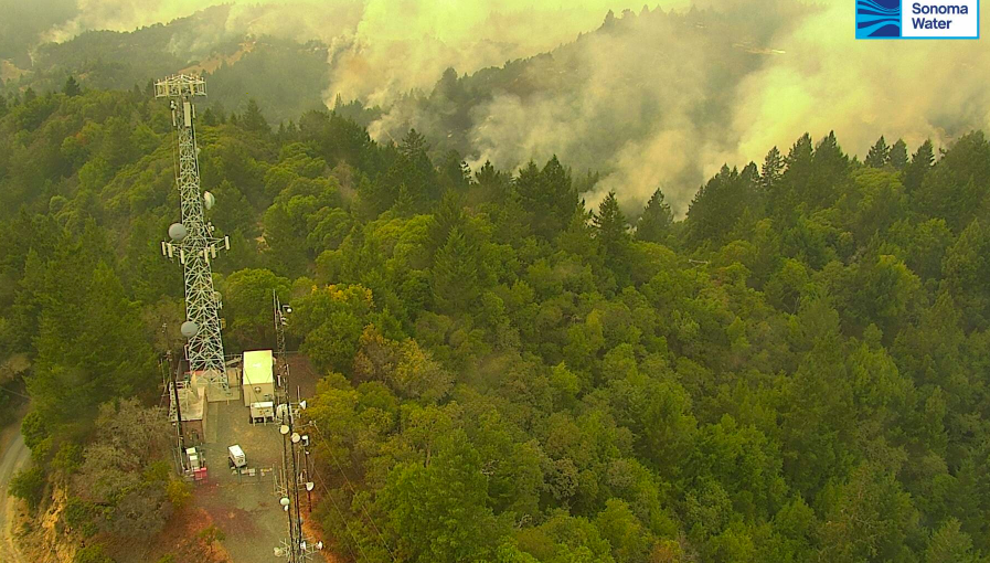
Mt Jackson cam is about to go
http://www.alertwildfire.org/northbay/index.html?camera=Axis-Jackson&v=81e002f
Correction…Looks like a burning operation.
2 Likes
With all the hose down I thought they were going direct to save the Mt. Jackson Repeater. Its Crucial to all comms in Soco. Update: It does look like a burn op
1 Like
Keep in mind that the IR effects from the camera make the fire intensity look greater than it is. What you are looking at here is relatively low intensity burning. They are protecting the site and letting the fuels consume to get some good black around the site.
5 Likes
The Mt Jackson repeater has been prepped for the last two days. PG&E puts thousands of gallons of retardant in and around the site. The repeater will tolerate a surface fire no problem. It will not tolerate a crown fire.
7 Likes
Watching the crew try to maintain a foothold on Mt Jackson…any update from the ground?
Added a couple evac zones to this area…
1 Like
What is the difference in channels being monitored between the 2 scanners labeled
Sonoma Co Calfire vs Sonoma Co Northwest ???