
NIFC CMD-2 for the west
NIFC CMD-8 for the north
NIFC CMD-12 for the south
5 Likes
Does anyone have a copy of the ops plan?
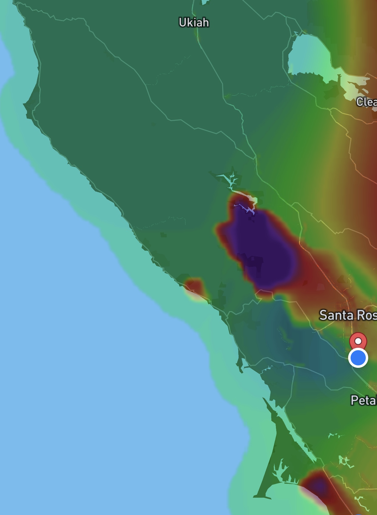
Looks like Meyers is lighting back up on the air quality index. This wind is bad news for the River communities.
1 Like
Per Complex AA the Meyers fire is looking really good. They are optimistic that they can get some containment on it today.
3 Likes
Per AA, 200 Yards North of Mt. Jackson, Backing down a canyon with no wind on it, Still moving south towards Rio Nido/Guernville
1 Like
Fire directly below the mt Jackson cam
http://www.alertwildfire.org/northbay/index.html?camera=Axis-Jackson&v=81e002f
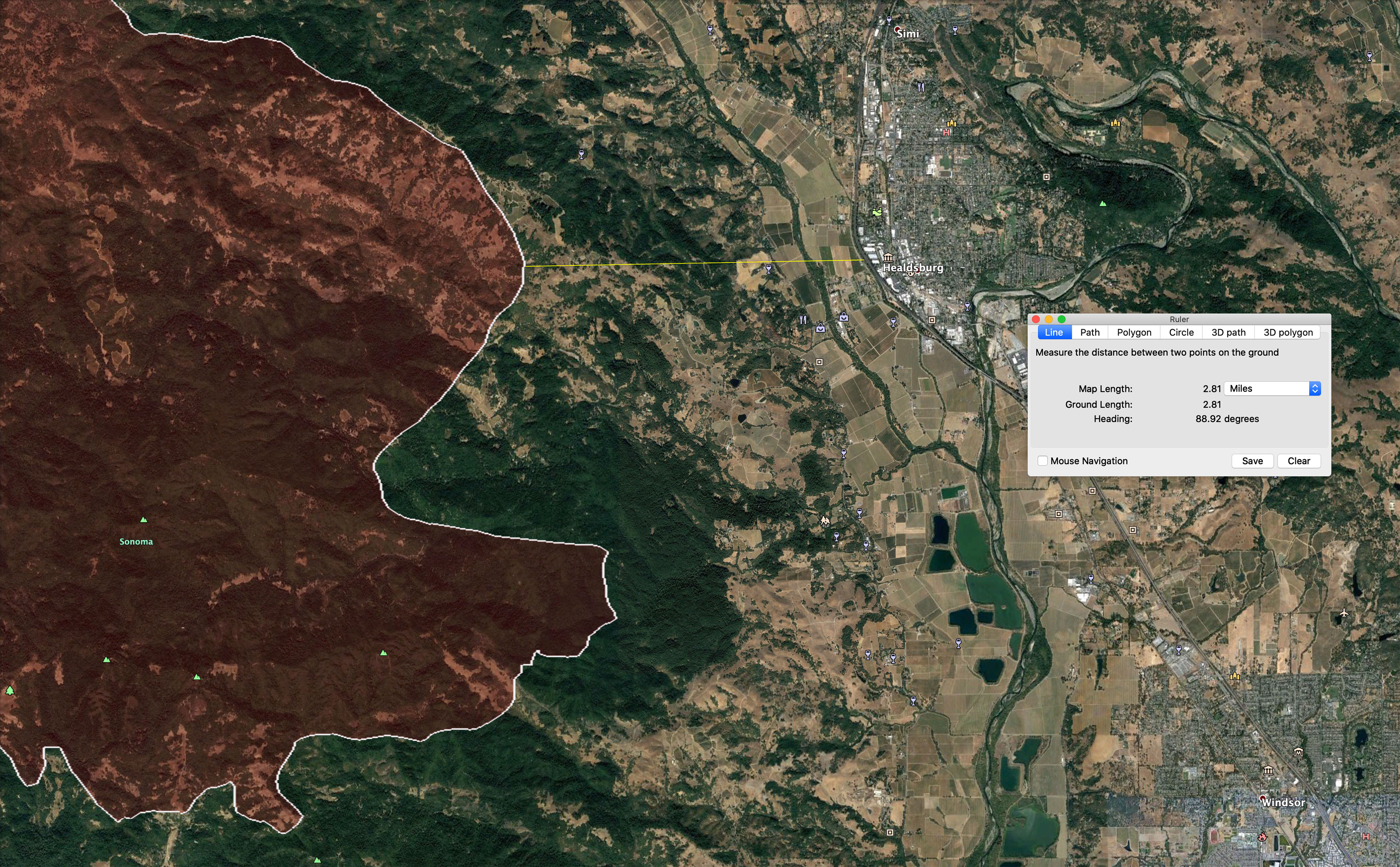
Some intel for those evacuated on the Westside of Healdsburg and Healdsburg propper. Based on this morning’s fire perimeter data, the fire is approximately 2.8 miles due west of Hwy 101 in Healdsburg, still up in the hills above Westside Rd.
3 Likes
UPDATED - Per Sonoma County Sheriff @ 1112 Friday 8/21
Mandatory Evacuation Order has been expanded to include all residents in the follow area(s):
Map Grid 4B1 Mandatory Evacuation
All areas south of River Rd. from Martinelli Rd. to the intersection of River Rd at Trenton Rd.
West of Covey Rd.
North of Front St. / Hwy. 116
East of Martinelli Rd.
Map Grid 2A3 Mandatory Evacuation
North of Stewarts Point Skaggs Springs Road to the eastern edge of Lake Sonoma
Everything west of the eastern edge of Lake Sonoma to the western boundary
that runs north along the ridge line from the intersection of Stewarts Point Skaggs Springs Rd @ Old Stewarts Point Skaggs Springs Road to the interception of Rockpile Road @ Cooley Ranch Road north to the Mendocino County Line.
2A3 This is a very rural area with no clear defining boundaries
1 Like
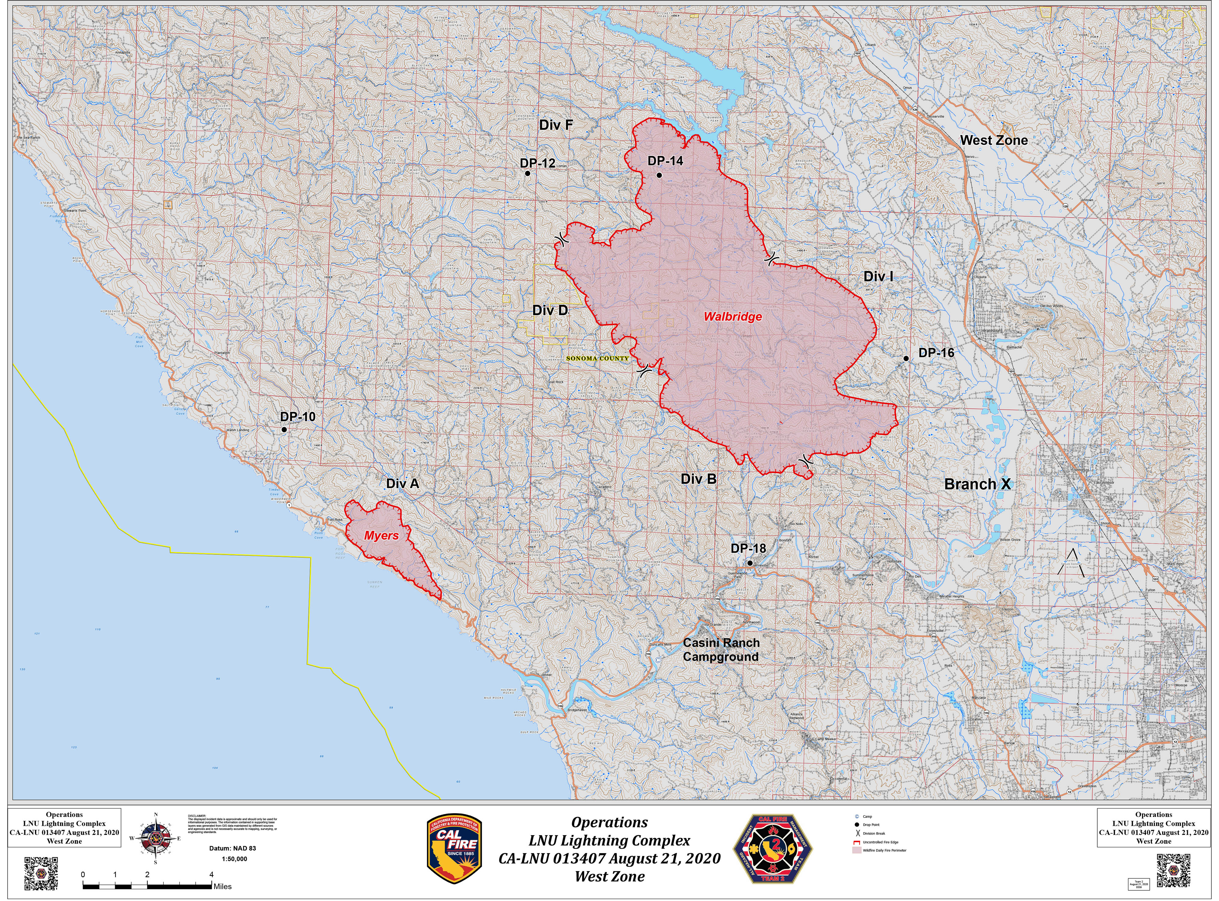
AM briefing says Walbridge fire 21,125 acres. Myers = 3,000. now these two fires are the “West Zone” of the LNU complex. Myers fire is basically not moving and the Walbridge is still headed to the south with potential for more evacuations.
They have done a re-org of the LNU complex into West Zone (Walbridge/Myers) and East Zone which started as 8 different fires all now merged into the Hennessy. Complex is now 219,067 acres altogether. They reported 4 civilian fatalities so far, 3 in Napa, 1 in Solano with no further details.
1 Like
Any new evacuations ? I am working today and haven’t been listening to the scanner consistently…
Yes. Small changes
2 Likes
Looks like this scanner is dialed into the scanner. Updated with all the West Ops frequencies. Not hearing much on the original scanner listed. Might want to change the original thread.
3 Likes
Anyone have a copy of the Walbridge IAP?
The Walbridge is part of the entire LNU Lightning Complex with both the West and East Zone being managed by the same IMT. They produce a single IAP and map set for the entire Complex, which can be found here: LNU Lightning Complex
3 Likes
Sounds like Mt Jackson is the priority today per AA. Fire is surrounding the repeater. No threat to the repeater at this time. They prepped it well!
2 Likes
***Edit to add link to Evac Map (easier to understand than the written descriptions)
EXPANDED EVAC ORDERS SAT 8/22 10:30HRS
1 Like

RED FLAG WARNING just issued for the fire area:
…RED FLAG WARNING IN EFFECT FROM 5 AM SUNDAY TO 5 PM PDT MONDAY
FOR DRY LIGHTNING AND GUSTY ERRATIC OUTFLOW WINDS OVER EXISTING
WILDFIRES FOR FIRE WEATHER ZONES 006…505…506…
Link to NWS SF for this warning.
2 Likes