New start near East Camino Cielo and Painted cave road. Column visible from Goleta/ downtwon Santa Barbara. SBC and LPF are sending a response
Showing from the ucsb camera.
http://www.alertwildfire.org/centralcoast/index.html
Correct link.
1 Like
The fire is named Camino, it is now 15-20 acres and burning down canyon.
Mandatory Evacuations for 154 East to Ontare Rd From Foothill up to the top of the Camino. Evacuation warning for 154 West to Fairview and Ontare East to Gibraltar.
Current conditions near the fire area NW winds 5-8 mph, gusts up to 27 mph. RH around 14%.
This fire should be on the LPF per SBC Info. Both SBC and LPF have units assigned. The fire is now 25 plus acres with Sundowner winds pushing it. I keep seeing conflicting info regarding the name. Camino or Cave Fire??
Apparently it is back to Cave Fire
Type 3 ST also en-route.
ANF sending Immediate need striketeam to the incident on the LPF. resources assigned : ENG-10 ENG-12 ENG-310 ENG-316 ENG-512 and PAT-15 for the investigation.
The HRRR model shows 25-35 MPH ENE winds w/ gusts to 45-55 MPH potentially driving the fire towards Highway 154. Strongest winds will be Midnight - 3 a.m.
Dispatch reporting entire area of fire will be without power in approx 5 minutes - possibly due to SCE Public Safety Power Shutoff PSPS.
AA07 had requested AA51 for night Air Attack, + 3 additional night capable rotor wing from LACo or VNC. Local XSB1501A at scene along with a robust first and second alarm from SBC and first alarm LPF. Plus the resources coming from ANF. Latest is 30 acres near where the Windy Gap fuel break hits the Camino. Lots of wind and pretty dry but cold up there.
The fire appears to be getting quite a bit larger and is throwing spots downhill in the wind.
2 Likes
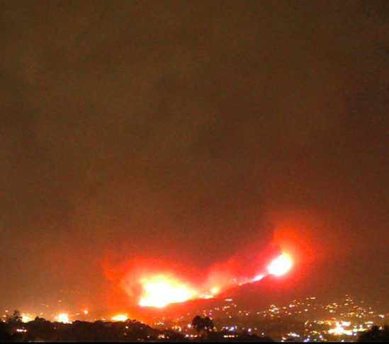
From a Local in the area, ‘’ Local amateurs report fire now halfway down the mountain, about 40 feet high flames, moving significantly faster than earlier."
Long range spotting now being reported.
Spot fire confirmed about 1 mile down canyon.
NWS calling for 100% chance of rain over the area tomorrow night, hopefully can keep in it check till then.
1 Like
LAC has now assigned some night water dropping Copters.
From Santa Ynez Peak: Not looking too good.
The fire is impacting structures on Mundo Ranch. Now 200+ Acres, IC requesting 10 Strike Teams of Engines (50) any type for imemdiate structure defense at Highway 154 X San Marcos Pass.
Showing up well on satellite images:
www.rntl.net/santabarbaracountyfirecams.htm
1 Like
Fire south/west side of 154
In the San Antonio creek rd Area
1 Like
That spot is burning back to the main fire by the looks of it.
I know it’s slightly off topic but looks like another start in Ventura county (northern near the LA county line). Maybe LPF?
Also another heat signature in Fresno county foothills.