I believe MNF is calling the Tatham Ridge the Gulch fire. There wasn’t anyone in the area when it started, so by the time MNF got on scene to assess the “situation”, it was already quite the “situation” and they didn’t know if it was a spot, something new, or if it was a rekindle of the Tatham lightning strike from Sunday. It burned over Round Mtn twice, and then marched over the old Eagle Peak lookout site (unknown on status, the TGU ECC camera operator kept checking it before the Round Mtn cameras burned up) and has crested over and working its way down into the valley above Paskenta it sounds like. I have been off raw intel for the last few hours so counting on secondary resources.
2 Likes
What’s a Pine Kop and a Rockwell?
Thank You for the information…That is our stomping grounds.
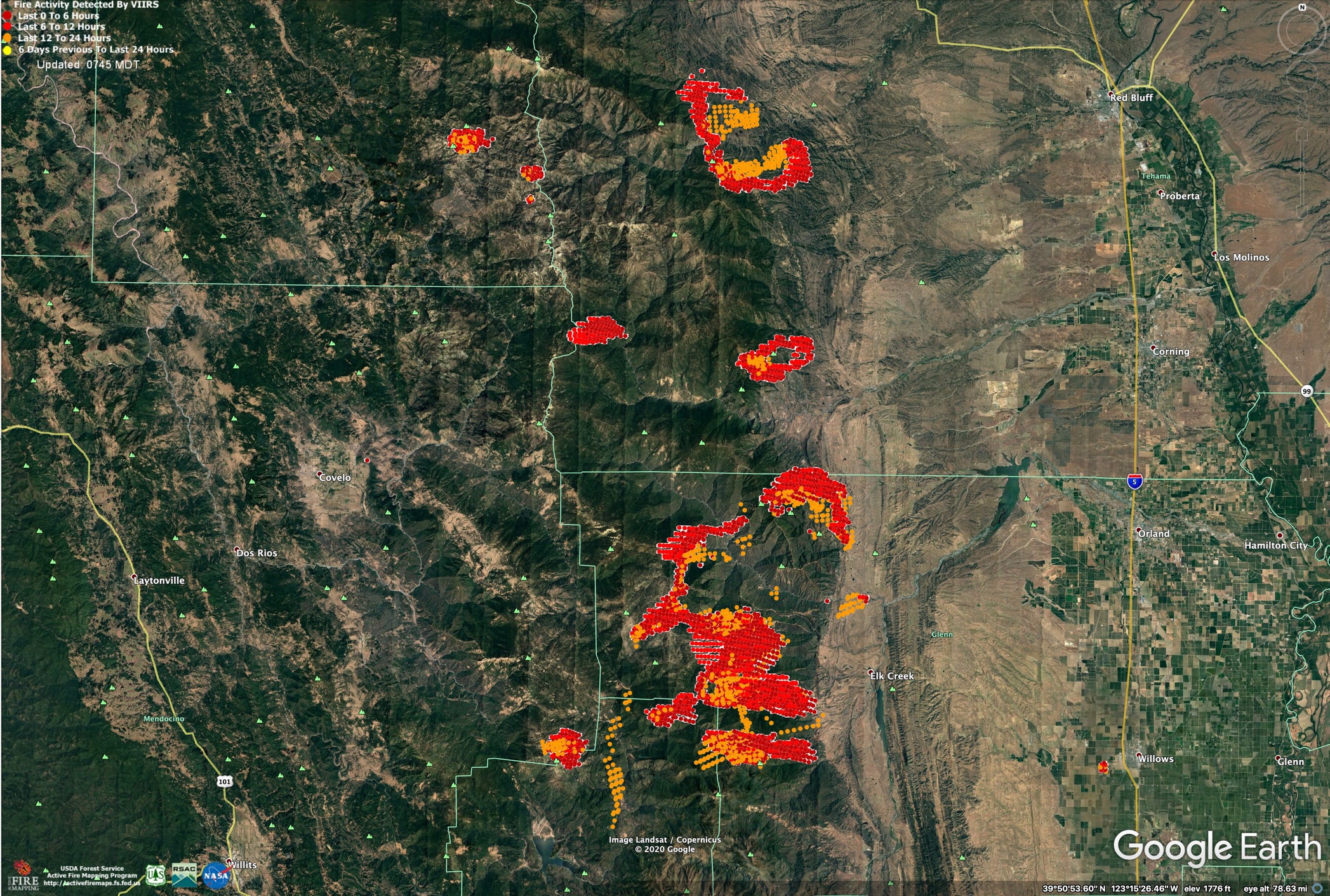
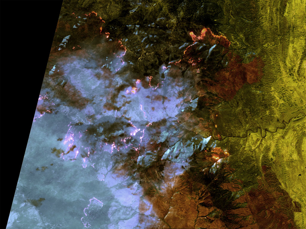
VIIRs heat detection data at 2am, 8/20/2020.
Red is fire growth between 8pm and 2am. Orange is from 2pm to 8pm, on 8/19/20.
3 Likes
Is there any information on the status of Salt Creek Camp??? Or the status of the Gulch Fire???
I think they did a lot of prepping and firing behind them in the saddle yesterday to bring the black up to the main fire backing on the ridge above them. The main fire is now making a huge hook around the west side up and over the eastern end of Log Springs Ridge and getting well established on top of the ridge, and trying to get into Thomes Creek drainage - east west aligned. CalFire C902 was at the camp all day yesterday.
Gulch Fire seems to have slowed the easterly march this morning, and is blowing out the back end. It’ll have influence from the fire behind it to the west along Elk Ridge. That fire got established in the Thomes drainage and its going to suck Doe and Gulch towards it. Check the TGU Lightning thread for a bit more narrative from last night. I’m hobbled on data and screen size today and scattered for a bit.
Well I really appreciate the info norcalscan…Log Springs was my summer home for about 3 years back in the late 80s/ early 90s. I know you’re VERY busy, but if you hear any information about the status of ranches and homes below Salt Creek…Structure protection plan, that sort of thing, I’d sure be grateful to know, my Dad’s place is just 3 miles below Salt Creek.
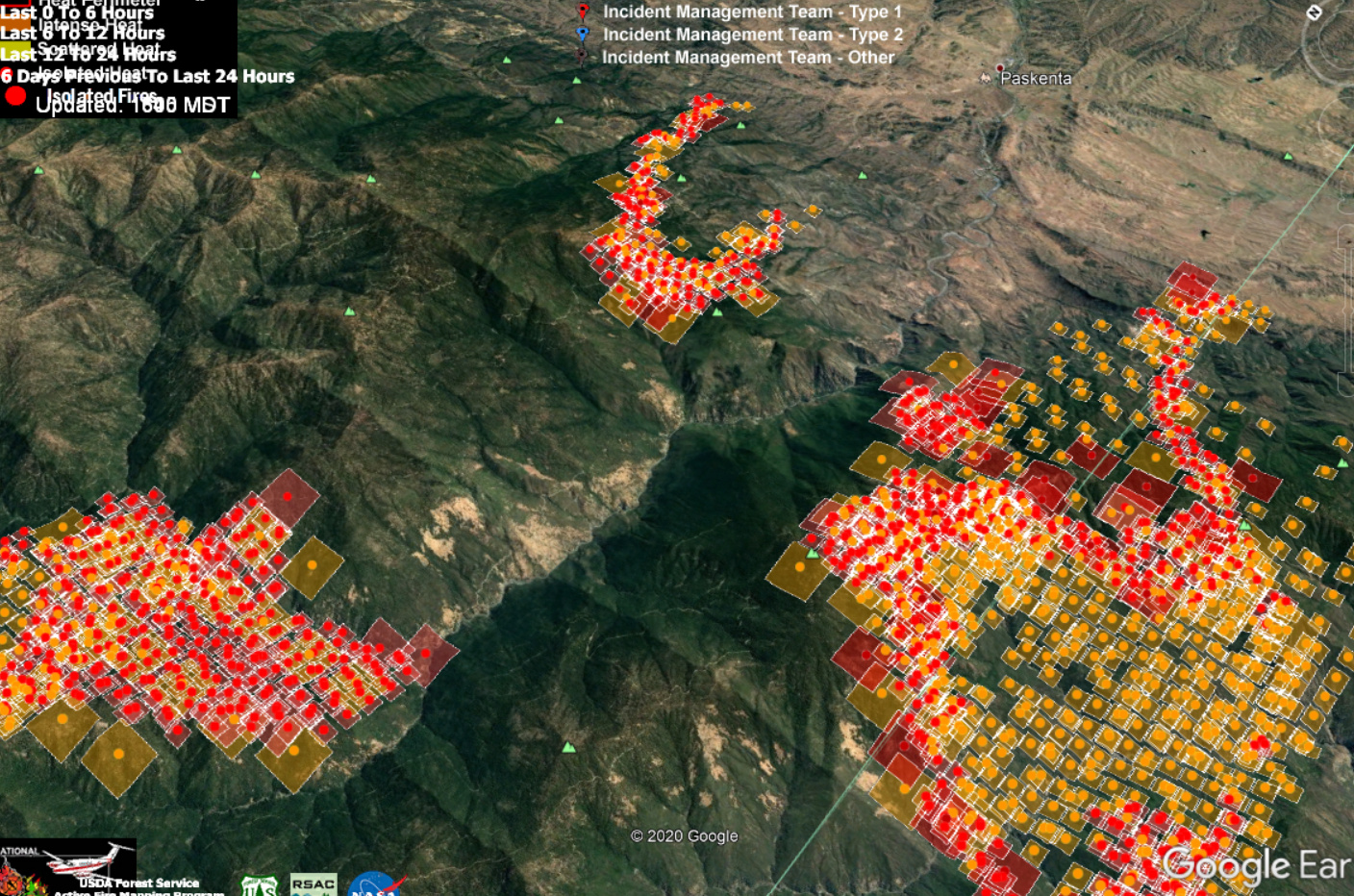
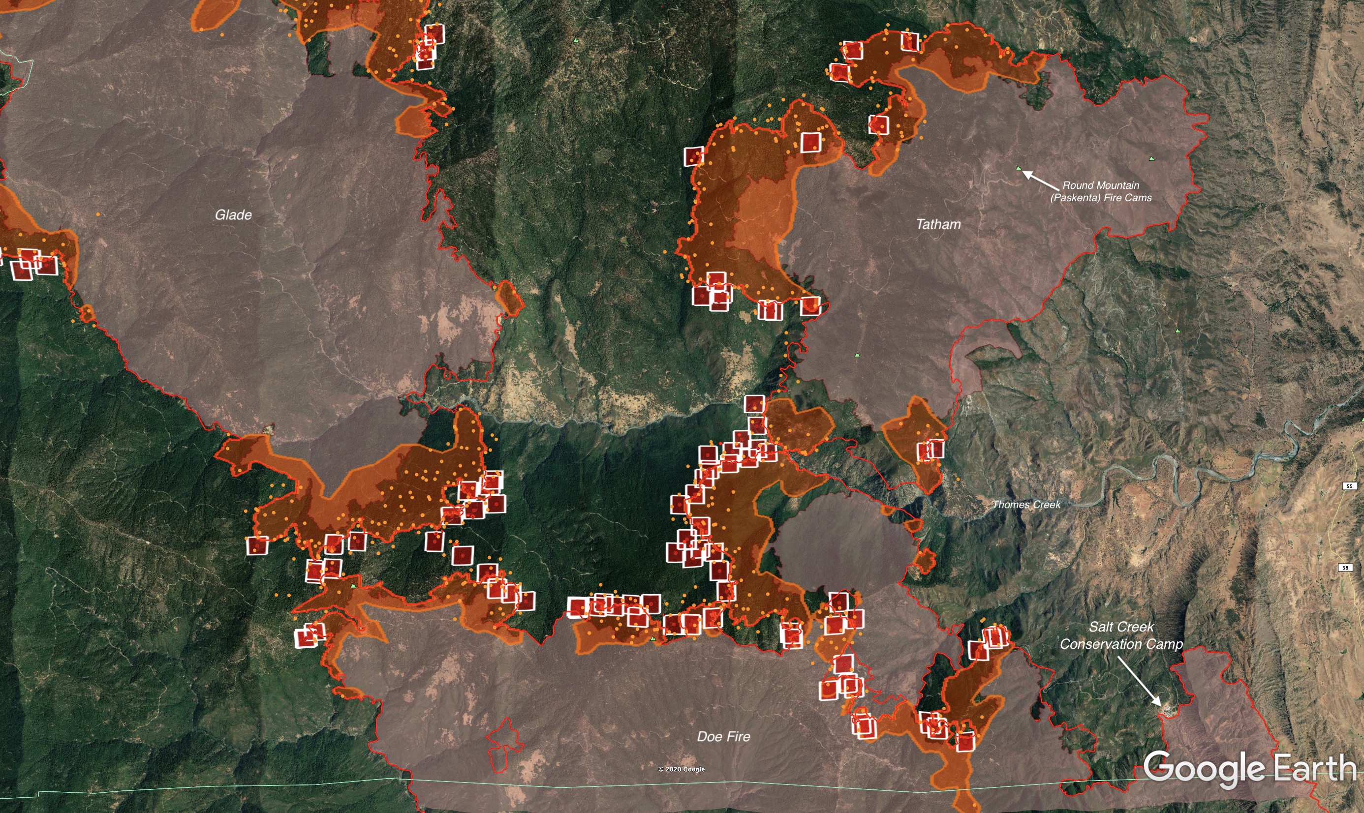
1300 Gulch, Glade, and Doe Fires
Gulch Fire coming out of the west of Paskenta. The GOES17 IR right now has it quite a bit cooler than neighboring fires. According to MODIS/VIIRS satellite imagery, the fire wrapped around the north side of Eagle Peak (old fire lookout, and RAWS station) and worked NW down the slope into the little saddle with ranch buildings at the NW base of Eagle peak. Eagle Peak appears to have only taken indirect heat on the first night, with the RAWS reporting a peak 93F and a Fuel Temp of 117 at 8pm the 19th, 3 hours after Round Mtn burned over. TGU has been testing the portable repeater they had up there as well and it’s still up. It was still significantly west of Pellows Road. I’m hearing traffic of bringing dozers north up Pellows Road all the way to Brush Mtn and eventually Raglin Ridge, which can easily tie into Elkhorn off Colyear Springs. This traffic MAY have been contingency line traffic for the Elkhorn and not primary for Gulch, but the either makes sense for either fire. Not sure if they are hoping to keep the two fires separate but (editorialized here) I bet Calfire’s biggest intent is to keep it from further eastern spread, and push it back to the forest where it no longer becomes their problem. I heard tidbits on Mendocino side that seem to correlate, where they think that’s CalFire’s bigger picture, but not sure if the two Ops sides have a clean line of communication or not to coordinate (no bad blood, just sheer overwhelming logistics, overhead, and resource drawdown, minimal cell coverage, and multiple political boundaries all tied together with SHF, MNF, SRA, Private logging, etc). MNF was tying in with a private logging dozer on Riley Ridge between both fires, and hoping to rope them onto a CWN and put them to work. The MNF certainly doesn’t want the two to burn together on the forest side - lots of good timber in there. Hope they have the resources to pull that off.
Looking at the south and west ends of the fire, it’s all over Tatham Ridge and Whiskey Saddle area, and working down the eastern aspect of All Top towards Thomas Creek. Thomas Creek separates this fire from the Doe Fire right at the Gorge basically.
The Doe Fire I have no radio intel on, just MODIS/VIIRS interpretation along with GOES17 IR. GOES17 shows a LOT of heat still, but slower spread, moderated by the same inversion I believe and socked in by smoke. Salt Creek Conservation Camp had a lot of prep and I believe fired out the back of it in the saddle, bringing black to the main fire above it. Calfire Copter 902 was on site all day yesterday.
The Glade fire is further up the Thomas Creek drainage to the west behind Gulch Fire. Just as I predicted last night, this fire made it into the Thomas Creek drainage and blew east into the drainage and will definitely be influencing the back end of Gulch Fire, and the northern head of Doe Fire. The Thomas Creek drainage is east-west aligned, right with the diurnal winds. All three fires are either in, or right on the ridge of the drainage.
(edit)
Here’s the Gulch up top, Glade to the left and Doe to the right, looking nearly east and down the Thomas Creek drainage into Paskenta. This is setting up to be an interesting scenario of wind terrain alignment, three fires, minimal resources, and a remote (yet evacuation-ordered) community at the bottom of the drainage.
4 Likes
Thanks for the update!
The Glade fire definitely got someone’s attention this evening. Two MAFFS on it, with two more MAFFS diverted off LNU to this fire, and T01. I’m no FOBS, but this setup with the aligned terrain is tickling my spidey senses…
Thomas Creek RAWS - at the mouth of Thomas Creek into the Paskenta area, will be the station to watch tonight and tomorrow night. Two evenings and early mornings ago were significant west winds and gusts. Last night and this morning were relatively calm, matching today’s fire behavior in the - sort of subdued, overall, due to the WX conditions.
Eagle Peak RAWS will give an idea of what’s happening midslope NW of Paskenta. It is right in the middle of the Gulch Fire.
The PGE Round Valley WX station is just south of the Thomas Creek RAWS, but is slightly sheltered from Thomas Creek influence, more of what is coming off the southern side of Log Springs Ridge, and also what the northern head of the Doe Fire is seeing. This is at the northern mouth of the long saddle/valley that Salt Creek Conservation Camp sits.
4 Likes
Thank you for the updates and hard work!!!
1 Like
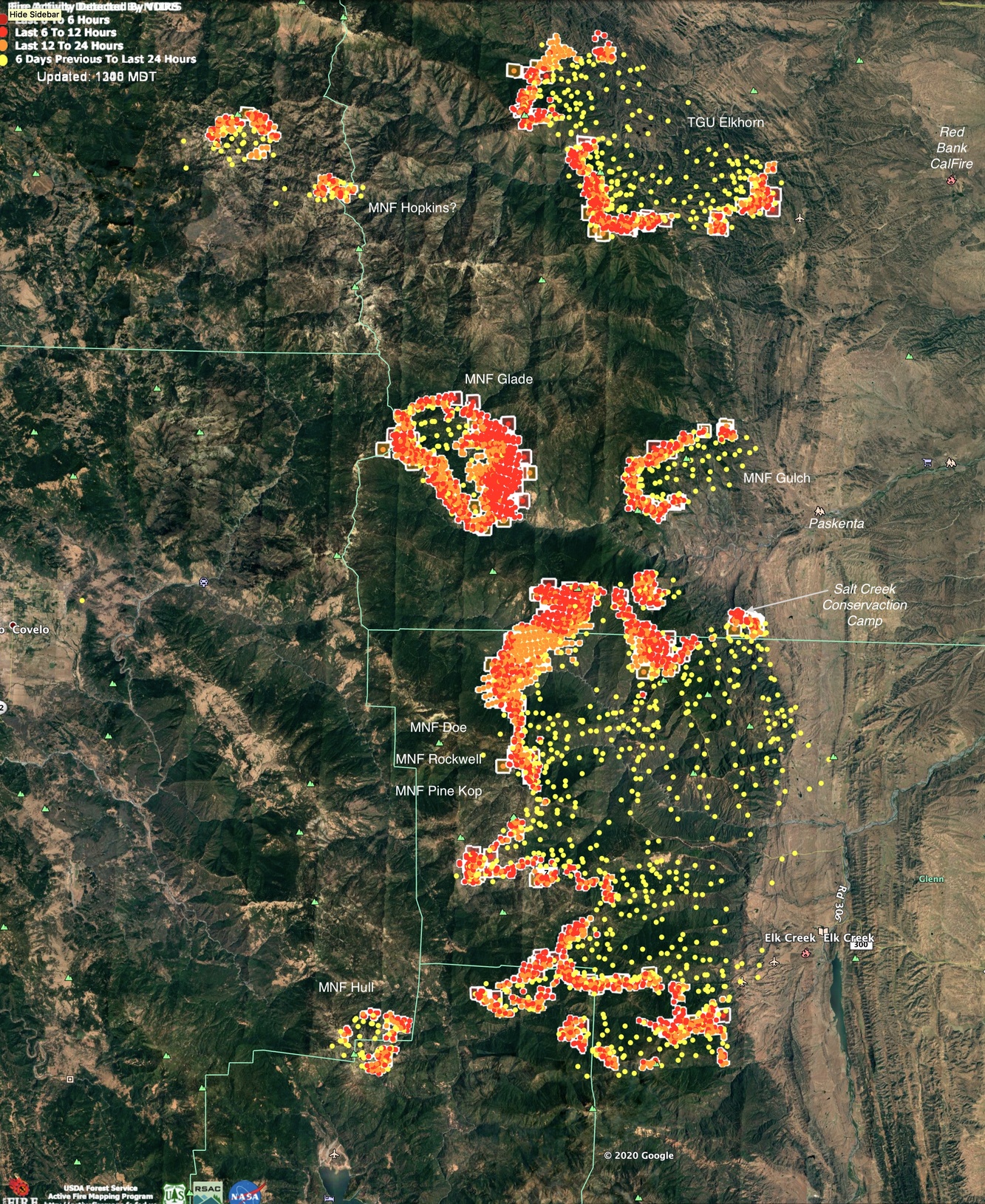
Here’s an overview of what’s up here in northern half of MNF today
Also, someone was seeing the setup of a perfect storm on the Glade fire last night and put some resources in there to fire off what appeared to be the SE piece of the fire to give it every chance to stay out of Thomas Creek drainage. The MAFFS tankers were backing up the firing operation last night. That coupled with the forecasted westerly winds never materializing helped take two big variables out of that perfect storm.
5 Likes
Here’s a satellite view of the August Complex on 8/25/2020.
3 Likes
Lots of aircraft outside the redbluff area. Is it on the mnf? Saw 944 inbound.
1 Like
It’s for TGU-Elkhorn, but indirectly it’s an all out fight to limit spread into the Yolla Bolla Wilderness and the SHF there right northwest of Tomhead Lookout. Last night and today was the first chance they had at clear skies from a week of being smoked in so they’re hitting it hard now in the area of Brushy Ridge and Forest Route 35.
5 Likes
Thanks NorCal scan
1 Like
Not confirmed, but I believe today the Tatham, Glade and Hull all connected with Doe. If not, they are extremely close. I have only done light monitoring of the fires this weekend to catch my breath, so have not looked into their big picture on the MNF side.
The scancal live scanner has MNF August Command, A/G Command, A/G Tactical, Air Tactics and Rotor Vic on, however it is directly behind the TGU-Elkhorn Fire at the moment. Besides the alpha tags, MNF traffic can be discerned by the telltale NIFC linked double-squelch.
Looking at total acreage involved with Mendocino today in the last two weeks, and looking at 2018 Ranch Fire numbers.
- 2020 August Complex (as of 8/30) - 221,284 acres (214,906 nearly continuous) (24.2% of total MNF)
- 2018 Ranch Fire (Mendocino Complex) - Approx 284,000 acres of MNF land. (31% of total MNF)
I’m sure @pyrogeography will look at this same topic later in much better depth.
On the south side, Doe and Hull Fires close to coming together early this morning. 2018 Ranch Fire in blue.
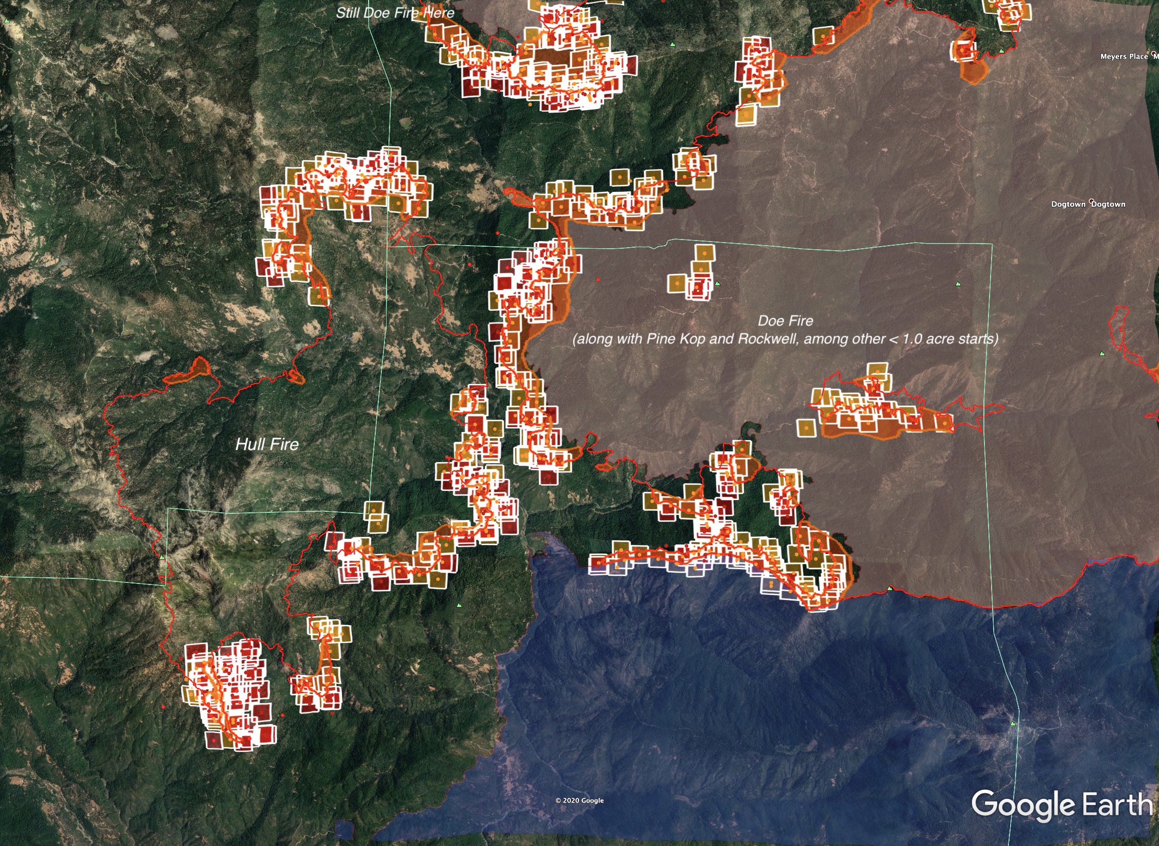
On the north side, looking at last night’s IR maps and early morning MODIS/VIIRS the Glade and Tatham fires have basically met.
4 Likes
5 Likes
Is this what you mean by a Sentinel image that has been ‘ground-truthed’? (referring to the thread over on CA- PNF- North Complex Continuing Fires and Incidents)
When BAER teams make a fire severity map, they start with a satellite image like the one I posted there, and then get out to hike the ground and see how well the imagery matches the real conditions (ground-truthing). Then they adjust the mapping to better match reality.
4 Likes