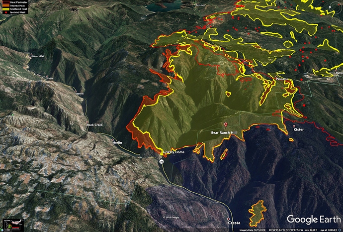
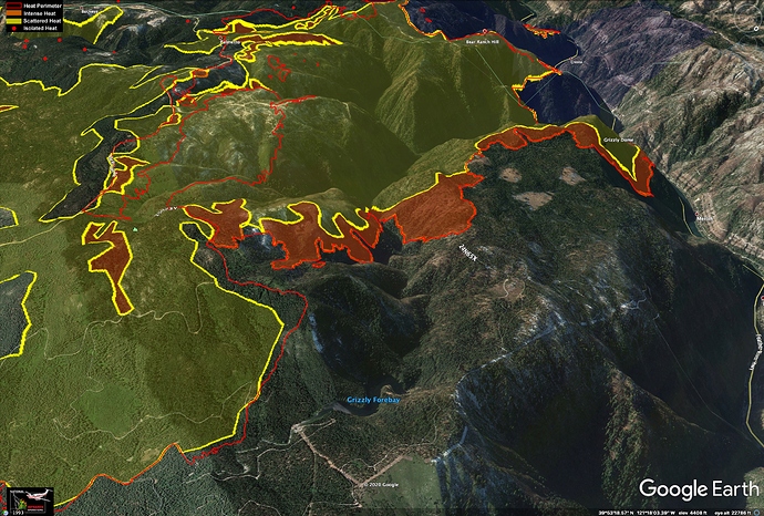
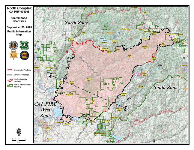
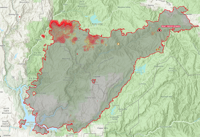
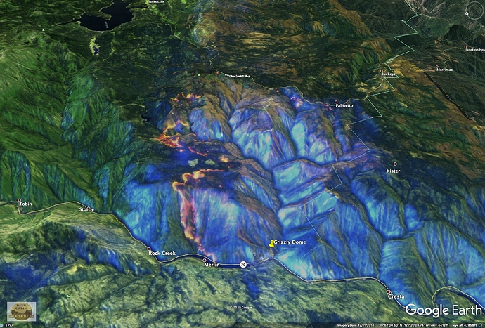
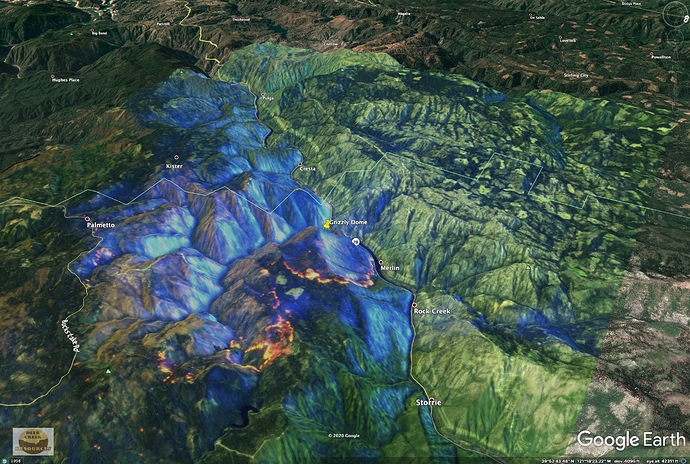
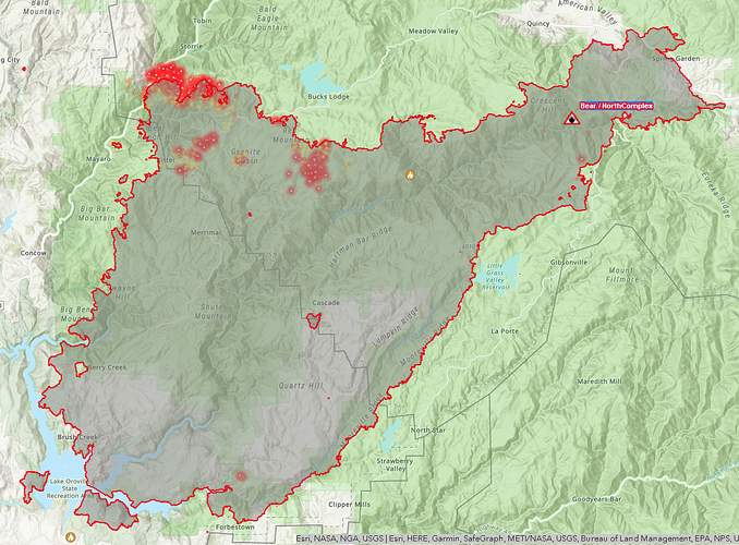
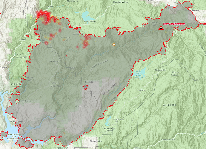
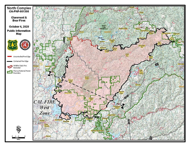
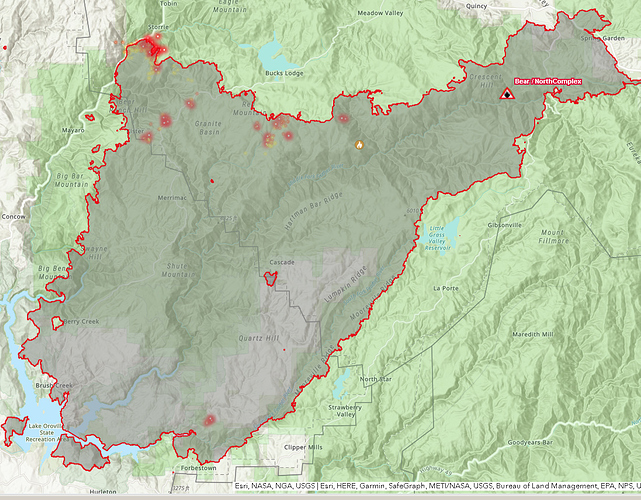
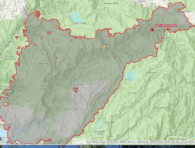
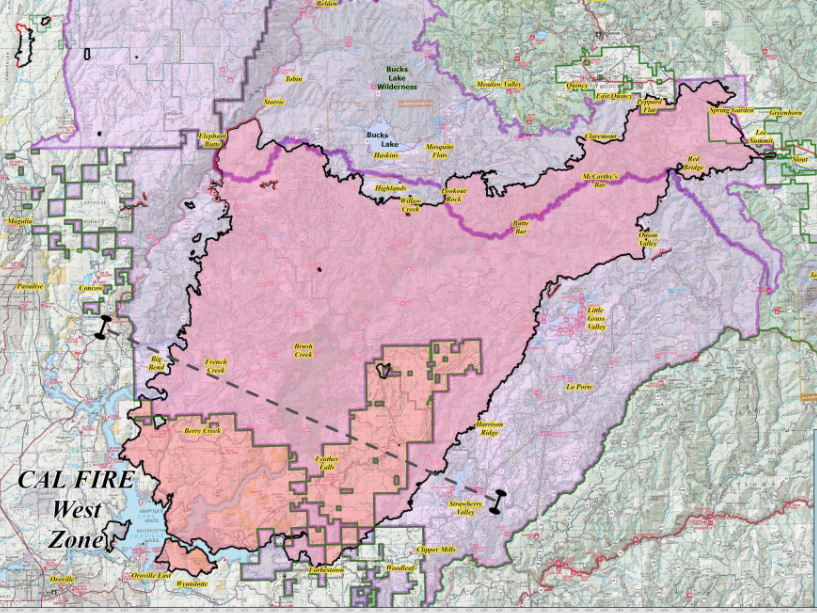
Yeah, it pretty much confirms my fears that there is more than sufficient fuel loading to carry fire in most places. And with the fires march to the bottom of the canyon it’s becoming more of when instead of if…
And by the way, enjoyed your slide presentation. Very informative.
Butte Wx Spotter FB page at 0755: with screen shot from CA Fire Scanner @CAFireScanner (no time noted on screen shot). “0500 #Bear Fire, #North Complex (Plumas/Butte Co) - AA7HS overhead, reports the fire closest to Hwy 70 has subsided (no reports of it crossing). Main Fire activity is around the Grizzly Forebay, short range spotting observed but they may be within containment lines.”
On the 3am VIIRs data and this morning’s Flea Mtn cam at about 0630, it looks to be well established into Bear Ranch Creek, South of Grizzly Dome, with a spot above the Cresta Powerhouse.
Tonights USFS evening update
https://www.facebook.com/USFSPlumas/videos/northcomplex-evening-operations-section-briefing-9-29-2020/3228086067240647/?so=permalink&rv=related_videos
Last Updated: September 30, 8:00 a.m.
Size: 314,949 acres Containment: 79%
North & South Zone :
Night crews maintained a heavy presence on the Highway 70 corridor and as of 7:15 a.m. this morning, the fire had not spotted across the highway. The fire does remain well established in the vicinity of Grizzly Dome Tunnel and has bumped up to the highway along a half-mile section.
Other night shift resources patrolled the remainder of the fire’s containment lines, which continued to hold.
Resources today will be focused on the Highway 70 corridor working to keep the fire from crossing the highway, containing any spot fires that do occur, and preparing structure protection for threatened buildings and critical infrastructure. Predicted weather conditions are favorable and should allow for the heavy use of helicopters in supporting these Highway 70 efforts.
https://www.facebook.com/USFSPlumas/videos/northcomplex-morning-operations-section-briefing-9-30-2020/430173067951482/?so=permalink&rv=related_videos
Tonights USFS Update
North & South Zone:
The fire continues to burn actively within the Highway 70 corridor near Grizzly Dome Tunnel, but has not spotted across the highway, nor made any significant runs as of 7:00 p.m. tonight. Helicopters effectively engaged the fire after this morning’s heavy smoke lifted. Resources are focused on keeping the fire from crossing Highway 70.
There were no containment issues along the remainder of the fireline, with good progress continuing to be made in the Bucks Lake and Highlands areas.
Crews will continue to work overnight along Highway 70 to monitor for spot fires and preparing structure protection for buildings and critical infrastructure. With active fire on the steep slopes above, firefighters are reporting rock and tree rollout making its way onto the road
Size: 316,685 acres Containment: 79%
North & South Zone :
Crews worked overnight within the Highway 70 corridor to monitor for spot fires and continue preparing structure protection. The fire continues to gradually grow to the northeast from the Grizzly Dome Tunnel area but has not spotted across the highway.
Other night shift resources patrolled the remainder of the fire’s containment lines, which continued to hold.
Today, firefighters will again be focused on constructing and reinforcing containment lines both to the north and south of the fire within the highway corridor. They will be supported by multiple heavy helicopters as soon as flying conditions allow.
Oct 3 USFS Morning Report
Size: 317,459 acres Containment: 83%
North & South Zone :
Night crews maintained their presence on the Highway 70 corridor and as of 7 a.m., the fire had not spotted across the highway. The fire does continue to gradually move to the northeast, beginning near Grizzly Dome Tunnel and bumping up along the highway for about two miles.Other night shift resources patrolled the remainder of the fire’s containment lines, which continued to hold.Resources today will remain focused on the Highway 70 corridor, utilizing heavy helicopters and single engine air tankers with retardant while crews reinforce dozer line and existing roadways. The rest of the fire’s perimeter will continue to be monitored for any sources of heat.The North Complex will be transitioning from a Type 2 Incident Management Team to a Type 1 Incident Management Team. This will be the last update from Rocky Mountain Incident Management Team Black and at 6pm today, Team Black will transition the fire to California Interagency Incident Management Team 4.
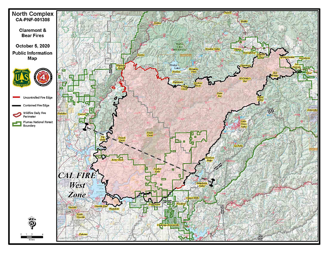
October 5
Size: 318.724 acres Containment: 83%
Crews continued putting in hose lays and brushing along the along the penstock to prepare the terrain for when the fire reaches the area within the next 24-48 hour period.
Fire tactics are looking into utilizing drones to introduce fire into the extremely steep terrain around the penstock to reduce fuels and provide for firefighter safety. A helicopter dropping ping-pong sized balls that ignite on impact is being considered as a back-up if the drones aren’t available.
Fire fighters continue to focus on the east side of Highway 70. Today, dozers and crews will be opening old lines in the Camp Fire area to provide contingency if the fire spots across the highway.
The Lassen National Forest is assisting in preparing contingency lines to assist with protecting
structures and with structure protection
The fire has reached a bend in the river where its continued forward progress puts it across the river. As Well PGE has a Penstock in the area as well. However if it is able to cross the canyon it will run into the Storrie fire scar from 10 years back. Not a lot of fuel above RR tracks left .
Hahaha not a lot of fuel in the stories fire scar, not so sure about that a little wind on that 10 year old brush on the south facing slope might surprise you
Storrie Fire was in 2000.
I haven’t been up there since 2006, but it was a real mess then. 10 foot tall ceanothus with jackstrawed large pine branches everywhere. Can’t imagine things have improved since then.
Today, an expected cold front will bring increased winds from the southwest that will test containment lines. There is a threat of roll out of branches and logs that could cause fire to cross containment lines in the penstock area. Crews will focus on contingency lines in the area around Bald Eagle Mountain and Mill Creek off of Bucks Lake.State Route 70 is now open to one-way traffic control with a pilot car between Rock Crest and Rock Creek. However, the road can return to a full closure at any time due to fire activity.
Looks like the heat signature is less and Less… 40 percent chance of rain at this point on Saturday…
High pressure has broken down and onshore flow will continue through the end of the week. This will result in some possible mist or drizzle near the coast tomorrow morning, while dry conditions will exist everywhere else for the next two days. Temperatures will also cool with this flow pattern, and near to slightly below normal temperatures are expected today through Saturday. A weather system is then expected to bring unsettled weather this weekend, with the threat of rain on Friday decreasing, and the threat on Saturday exiting mainly across northern Humboldt and the Shasta Trinity region. As the system exits the region Sunday, breezy northerly winds will develop, and may become offshore Sunday night into Monday. Meteorology will continue to closely monitor this wind threat. Fire danger remains seasonably high as live fuel moisture values are at critical levels in the lower and middle elevations and dead fuel moisture values are at seasonal minimums.
the potential for locally breezy and dry offshore winds to develop Sunday afternoon into Monday across Northern CA. These offshore winds will arrive on the heels of a cold front passing through the North. A cooling trend continues today with daytime temperatures in the 70s to low 80s away from the coast and sea breeze winds to 25 mph. Morning low clouds will be slow to clear near the coast and upper level cloud cover will spread inland as a weak weather system approaches the territory. However, no rain is expected with this system and chances for precipitation later this weekend have greatly diminished outside of the far North. At this time, the best chances for rain continue to be in Humboldt on Saturday, with light precipitation possible in elevated terrain surrounding the northern Sacramento Valley. Otherwise, dry through the weekend with temperatures at or below normal. As high pressure begins to build later in the weekend, locally breezy northerly winds will develop across the northern interior beginning Sunday afternoon and continuing into Monday and will be monitored closely. The cooler weather and potential for precipitation will allow fuels to recover some moisture, but fuels are expected to quickly dry out once the dry north winds return. A warming trend is also expected next week with widespread temperatures in the 80s to low 90s by midweek with some long-range models indicating potential for offshore winds near mid-month.
Incident Start Date: 8/17/2020 Size: 318,930 acres Containment: 95%
Engines: 15 Handcrews: 8 Dozers: 12 Helicopters: 2 **Water Tenders : 20
Total Personnel: 470 Fatalities: 15 Structures Damaged/Destroyed : 2,455
Current Conditions: Suppression repair continues in the North Complex Fire area. Firefighters are working to complete suppression repair in the Penstocks area so that PGE can get in and begin repairs to electrical infrastructure. Work continues near Buck’s Lake. There was a flare-up well interior of the fire perimeter but it did not threaten the fire-line. Additional internal smokes were reported on the northeast side all well within the fire perimeter. Red Flag conditions will continue to promote fire spread within the interior pockets of available fuel. Needle cast and areas of low severity burn continue to burn. Patrolling, monitoring and mop up continues south of Little Grass Valley.
A Red Flag warning is in effect until 1 PM Tuesday due to strong winds and low humidity. Gusty northeast winds of 15 to 25 mph with higher gusts predominated early in the day across the favored terrain areas and gaps. Humidity recovery was good in the lower elevations but generally moderate to poor across the mid slopes and higher elevations. Very cold air moves into the region on Sunday.
