CA-PNF-Sugar-??? (part of PNF-Beckwourth Complex) (Contained)

Setting up mobile repeaters(I think?) on fort sage.
Screenshot_20210709-131914-901

http://www.alertwildfire.org/shastamodoc/index.html?camera=Axis-FortSage&v=fd40729

3 Likes

VERY impressive cap seen from South of Grass Valley. Gonna be interesting with the collapse. Be safe all!

1 Like

4 Likes

Check out Chilcoot cam’s 15 minute loop

http://www.alertwildfire.org/shastamodoc/index.html?camera=Axis-Chilcoot&v=fd40729

Pretty early in the day for this level of activity. That thangs gotta be just hoovering everything off the surface.

2 Likes

ADVISORY MESSAGE The Beckwourth Complex Fire continues to grow. It is anticipated the fire could reach US 395 by 4pm. Truckee Meadows Fire & Rescue and Washoe County are advising our residents in the Red Rock and Rancho Haven communities to make preparations to evacuate livestock and large animals. The Reno-Sparks Livestock Events Center is opened to accommodate the animals. Hug High School (2880 Sutro St.) will be the evacuation center for people and small animals if needed.

US 395 is anticipated to be closed from HWY 70 to Doyle, CA. It is imperative that residents travel southbound on Red Rock and do not use the northern Red Rock exit on US 395. Washoe County

2 Likes

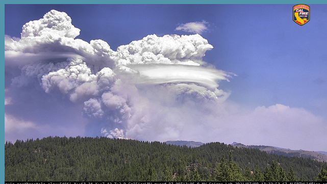
From Portola it has pileus clouds. Watch for rotation, lightning, and column collapse.
Screenshot_20210709-134651~2

http://www.alertwildfire.org/shastamodoc/index.html?camera=Axis-NorthPortola&v=fd40729

11 Likes

Looks like it is turned more northward than yesterday. The smoke ran across eastward as viewed from Schaffer Mountain, and now the smoke has a more direct approach. Sorry, no link at this time.

Heard on the scanner the fire actually turned west for a time. Fire behavior specialists warned of column collapse as well

3 Likes

Right on time with the afternoon buildups that are starting to pop up and it’s heading to the west.
https://rammb-slider.cira.colostate.edu/?sat=goes-17&sec=conus&x=7809.00048828125&y=3574.000244140625&z=4&angle=0&im=18&ts=1&st=0&et=0&speed=130&motion=loop&maps[borders]=white&lat=0&p[0]=cira_natural_fire_color&p[1]=cira_glm_l2_group_energy&opacity[0]=1&opacity[1]=1&pause=0&slider=-1&hide_controls=1&mouse_draw=0&follow_feature=0&follow_hide=0&s=rammb-slider&draw_color=FFD700&draw_width=6

3 Likes

Impressive for sure

4 Likes

Mandatory Evacuation of the northern Red Rock and Rancho Haven Areas was issued at 1615. Red Rock road runs from Stead (northern edge of Reno) north and east then loops back into US 395 at the north end of Long Valley just south of Doyle. It’s a good guess that the fire has either crossed 395 or will do very soon. The way I read the column from the vantage point of Bordentown it may be climbing the mountains just east of 395.

3 Likes

There have been reports of downstrikes occurring out of the Sugar Fire column. The top of the column has topped out at about 40,000 ft. Must be some violent fire behavior and up drafts down at ground level.

From NWS Reno
Emergency management reported lightning strikes along the east side of the Beckwourth Complex. Hot, dry, & unstable conditions have allowed these wildfires to become plume dominated generating pyrocumulonimbus. If you are in the vicinity please heed orders from officials.

3 Likes

Thunderstorms rolling in from the south, right now around Carson City, with downstrikes witnessed and multiple fires reported. They will have at least some effect on the fire as they continue north.

2 Likes

http://tiledisplay.alertwildfire.org/?urlcamset=Axis-AntelopeMtn&urlcamset=Axis-Beckworth2&urlcamset=Axis-Chilcoot&urlcamset=Axis-Constantia&urlcamset=Axis-NorthPortola&urlselectedviewing=true

3 Likes

From Dixie Valley. You guys ever seen this?

32 Likes

Very impressive.

Comm Techs from the incident were setting up a NIFC repeater and expanding their network out ahead of the fire.

3 Likes

Those are pileus clouds. A common name is scarf clouds. They form when the column is rising fast and pulling “relatively moist air” in and up parallel to the column. The water in that rising air is condensing showing the flow lines of that air around the plume.
Make sense?

23 Likes

Taken from Susanville at1830 hours.

5 Likes

Thank you , I learned something today , I’ve never seen that type of cloud , very good explanation!!

3 Likes