State ID: CA
3 letter designator: RNP
Fire name: 4-6
Location: Pt. Reyes National Seashore near the Woodward Trail
Reported acres:50+
Rate of spread: MROS
Report on Conditions: Bishop Pine and mixed brush
Structure threat: No
Resources:
Hazards: Heavy fuel unburned in a century.
Weather: 78 degrees RH 25 Winds 21 G 36 NW
Radio channels:
Scanner link:
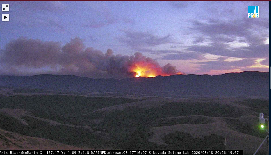
Webcam link: http://www.alertwildfire.org/northbay/index.html?camera=Axis-BlackMtnMarin
Agency Website:
2 Likes
Just texted with someone on the copter recon said several hundred acres at 19:00 hrs. This area has some of the heaviest fuel load I have ever encountered. Logging stoped in early 70ies. Park took the land in early eighties. All the roads on the west side of the ridge were removed or turned into foot trails. The 96 Vision Fire was stopped along sky trail to the south the last decent topographic feature until you go way south almost to the Bolinas Mesa 10 miles south. This would be a challenging fire with full air and ground resources. With no air and few ground resources available and restrictions on dozers in the National Park this will be a long hard grind to contain and control. Be safe everyone!
FYI poison oak in the area is also as bad as it gets.
7 Likes
View at 2027
7 Likes
Having fought fire there in 1995, I can tell you it’s some of the thickest fuel beds around. The Vision Fire burned on a strong North then East wind for 48 hours and became well established in Bishop Pines. Once the weather changed to a more normal flow, it burned back west for another 48 hrs. Forward spread really wasn’t stopped until after two days of nearly ground wetting coastal fog. The weather tomorrow will continue to be a challenge and the long term forecast is far from promising. There is almost zero road access to this area and without hand crews, any containment or attempt to contain will be impossible,
7 Likes
Obviously reached the top of the ridge and looks to be a bit less than a mile long on top of the ridge(used GE Pro). This has grown far beyond the couple hundred acres reported from the first copter recon. This has a very concerning rate of spread in timber. The good news is a flat valley along hwy one to the east separating the Inverness Ridge from the Bolinas Ridge. If it moves east and managed to establish on the Bolinas Ridge it would be a different ballgame. Distant structures to the north, some ranches to the east but most are down on the valley floor, The Bolinas Mesa is 10 miles south but at this rate it may become a concern much sooner that it looked like a few hours ago.
9 Likes
Predominant NW WINDS which are an every day occurrence will toss itnall into alignment. Forecast shows your normal 10kts with gusts to 20 for the next 4 days. Being that it made the ridge, a normal marine layer will below the ridgeline, giving it far less recovery then the stuff down low.
2 Likes
This will be the Woodward Fire according to this 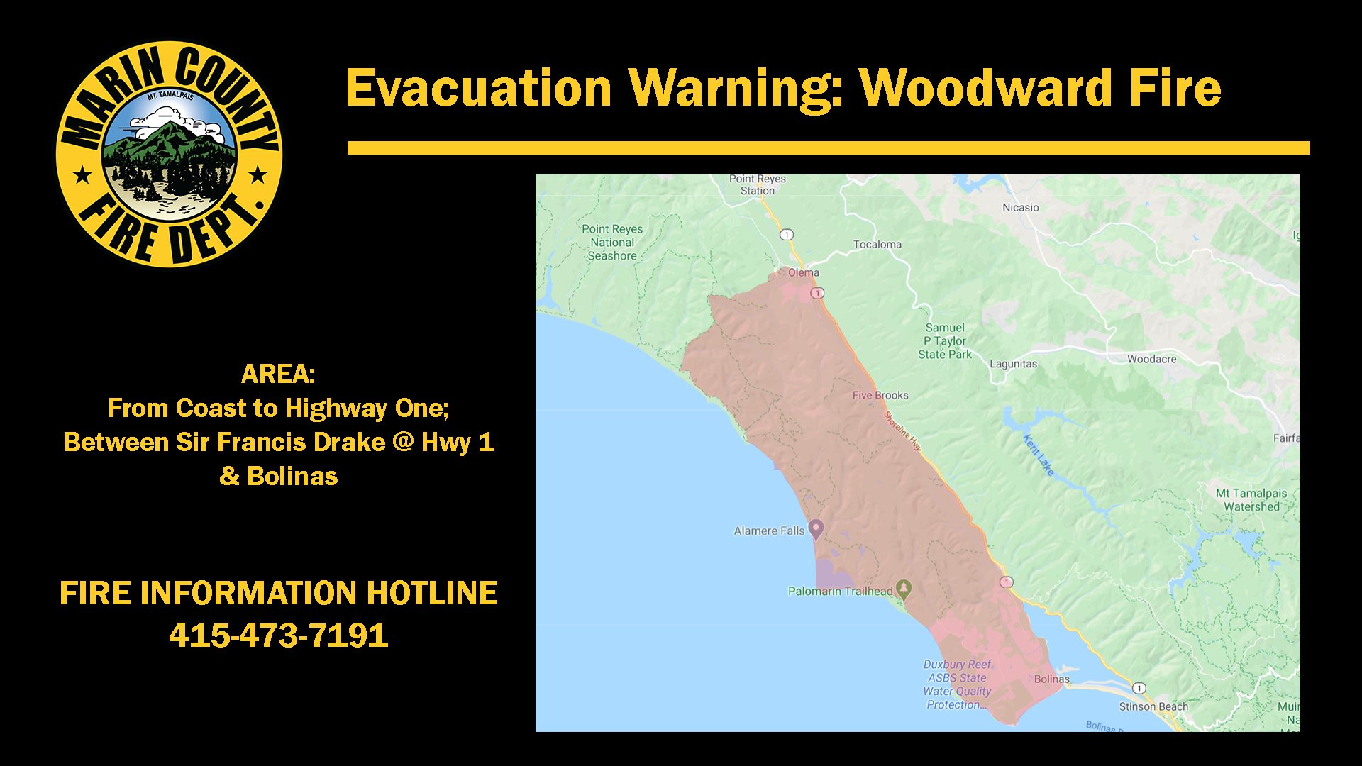
Reported over 700 Acres
2 Likes
This includes the community of Bolinas around 2K residents and only two narrow roads out
5 Likes
Fire burned actively throughout the night, made it to the ridge line. Extremely difficult access, very limited resources.
1 Like
Wind on it all day but not burning as hard as expected. With that said until they have lots of resources including air, this fire will not be stopped.
1 Like
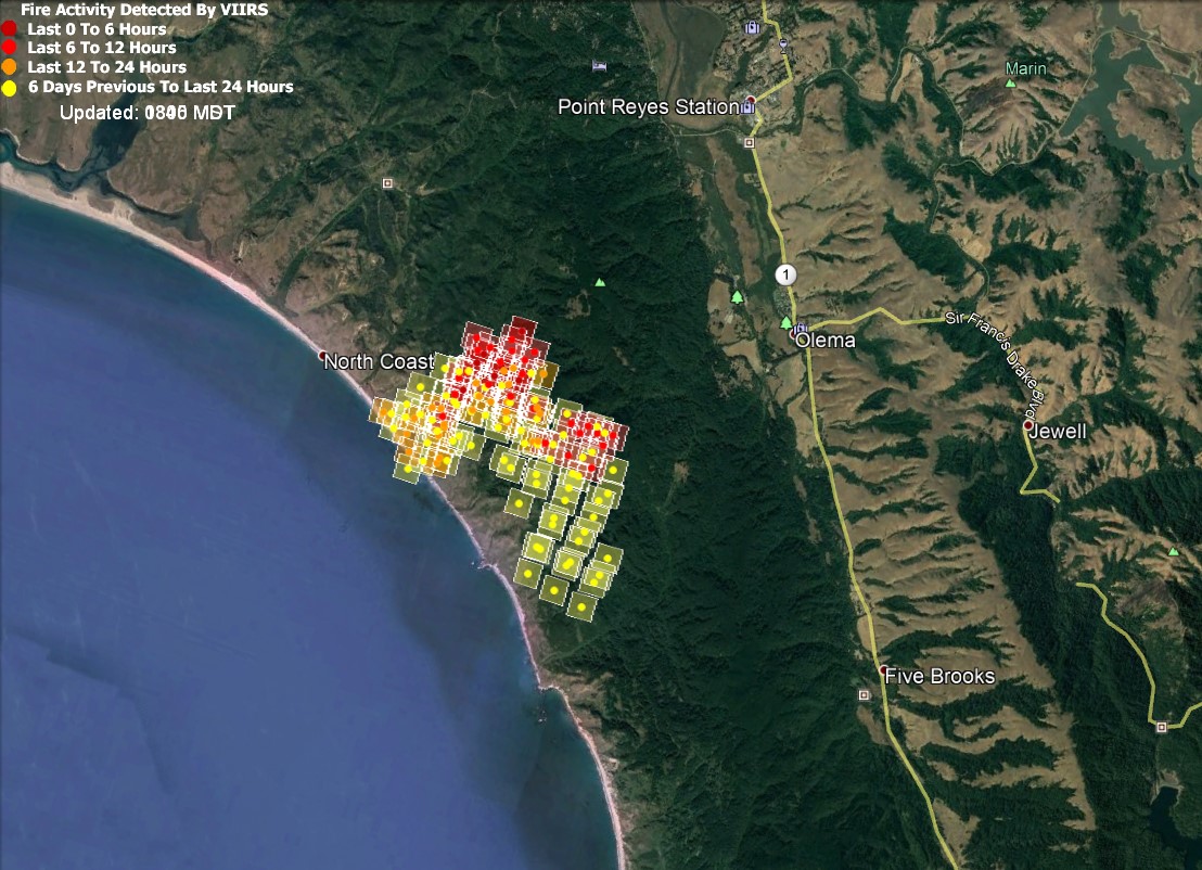
Latest VIIRS.
And looking at the cams this morning, the ridgelines didn’t get much help from the marine intrusion.
2 Likes
This has really taken off in the past 30 minutes. It’s clear on its way for Bolinas looks like
1 Like
No, it isn’t at this time. Also, LATs working the fire.
5 Likes
Northern Rockies Type 1 team is enroute to Woodward.
2 Likes
Watching KTVU 2 Copter Live and the fire has pushed south past the bear valley trail at the coast and the black Mt Cam looks like it is on the south side of the trail on the east side (Olema Valley as well). Access becomes more difficult south of the trail and absolutely no good topographic feature to build line from Hwy 1 to the Coast.
1 Like
Link to the copter video?
1 Like
This morning’s briefing over 2,000 acres, expecting some fill on equipment and crews. Fixed wing expected along with one or more copters, currently 110 personnel and 10 engines. Fire is still north of Bear Valley Trail and hopefully they can keep it that way. The topography gets really tough south of that trail all the way to the Bolinas Mesa
4 Likes
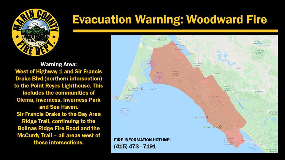
The Evacuation Warning has been significantly expanded to the north and east. This Fire is on the Barnabe, Black Mt and Mt Vision Cams
2 Likes
This should be CA-RNP-Woodward. Point Reyes National Park (NPS).
1 Like
You are correct but its Marin County Fire Departments DPA.
1 Like