
The Federal fires rarely, if ever, have the IAPS publicly available. The Fed policy is that the IAPS contain private information including phone numbers, so they do not upload those to the NIFC FTP server.
3 Likes
That used to be the case but some have posted. Most recently, the MDF-July Complex every day.
1 Like
It’s like the CF Team’s, some did and some did not for a long time, now most do. The adoption rate for the Fed teams is probably going take some time.
Side note: Should have said practice in my first comment as I don’t believe, or at least I am unaware of an official policy note surrounding that.
Red is 1252 acres, Salmon is 625. IR map:
2 Likes
3315 acres between the 2 fires, looks like they began firing ops yesterday. Thunderstorms possible over the next 2 afternoons.
2 Likes
Looks like a Type 1 Team will be getting ordered.
2 Likes
California Interagency Incident Management Team 4 (Kurth) In briefing Tuesday Aug 11,2020
4 Likes
Any talk about a type 2 team shadowing with the type 1??
1 Like
Well if you wait 48 hours you’ll have your answer…
2 Likes
They should.
1 Like
I don’t think strawhun team has much time left on a 14 day tour…unless they extend.
Would be another team that is married up with the type one.
Team 11 was originally slated to take over this week but was changed to the Type 1 team. Haven’t heard about any shadowing going on yet.
Strawhun is timing out. Good work up there. Accomplished a lot.
Reportedly adding a Hoopa Fire to the Complex. Which probably played a part with kicking this up to a Type 1 IMT.
1 Like
Yes CIIMT4
I imagine this is why they are going with a Type 1 team over the type 2.
From North Ops
CA-HIA Jones Point Fire : 150 acres brush and timber, 5% contained. Cultural and local ceremonial sites remain threatened. Threat to high value timber resources and endangered species habitat. The fire is burning in steep rugged terrain. California Type 2 IMT, Team 14 (Strawhun), assumed command at 1800 this evening.
2 Likes
7035 acres. Last night’s IR Map:
20200810 Red_Salmon_IR_TOPO_p11X17_compressed.pdf (412.0 KB)
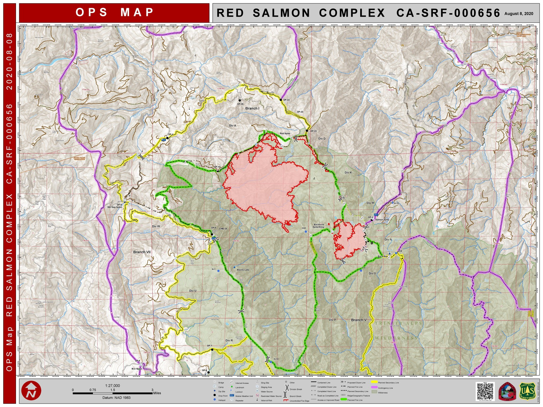
Link to Ops Map (too large to upload here): Definitely building a big box with this one, but so far, so good.
Coming down Siskiyou Summit on I-5 yesterday, smoke stretched from west horizon to east of Mt. Shasta. Shasta had fairly heavy smoke layer on the north side of mountain, at the 8-9000 foot level.
Another August - September air quality Alert setting up for the Klamath Basin. 
3 Likes