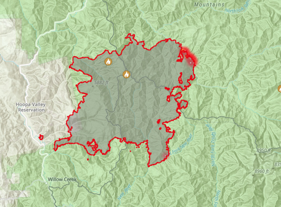
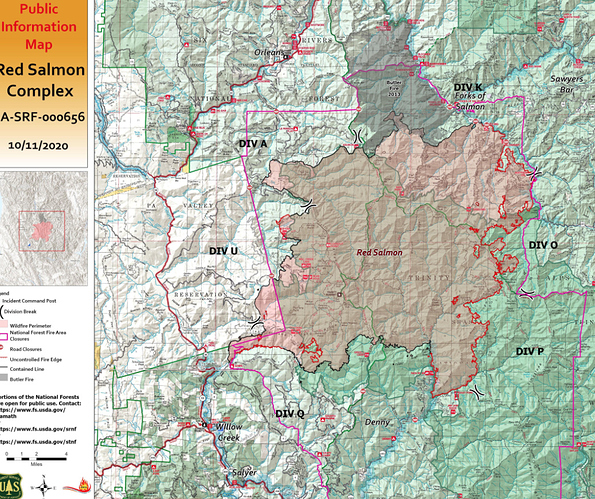
138,643 acres, 34% contained. This thing just keeps chugging along at about 3000 - 5000 acres per day. The IMET is forecasting 1/4 to 1/2" rain over the weekend, let’s hope it shows up. Cecilville will soon be threatened, especially with a west or SW wind event.
the potential for locally breezy and dry offshore winds to develop Sunday afternoon into Monday across Northern CA. These offshore winds will arrive on the heels of a cold front passing through the North, which is expected to produce a chance of precipitation generally north of Fort Bragg along the coast and north of I-80 in the Northern Sierra. No significant precipitation is expected outside of Del Norte and North Humboldt counties. Fuel moisture values are expected to increase in response to increased relative humidity and any precipitation that falls; however, fuel moistures are near critical values now and are expected to rapidly dry out when winds shift offshore. As high pressure begins to build later in the weekend, locally breezy northerly winds will develop across the northern interior beginning Sunday afternoon and continuing into Monday and will be monitored closely. The cooler weather and potential for precipitation will allow fuels to recover some moisture, but fuels are expected to quickly dry out once the dry north winds return. A warming trend is also expected next week
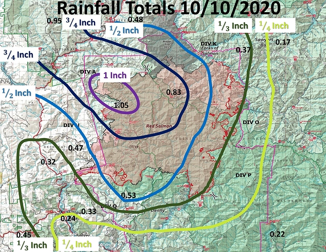
Yesterday, precipitation was received all across the fire area, ranging from one-third to one inch. Firefighters were unsuccessful in conducting defensive firing due to wet conditions. Crews finished setting up a community protection line around Godfrey Ranch. Crews also began suppression repair work on the north flank of the fire between Salmon Trailhead and Black Mountain.With clearer skies, air resources will be available to support ground crews for the first time in two weeks.
Today’s temperatures will be cooler and the area will start to dry and warm slowly as a high pressure system moves into the region. Winds will be from the northwest, with gusts up to 20 mph on the ridgetops. Skies should remain relatively clear with isolated areas of smoke. Saturday’s steady rainfall helped moderate fire behavior for the next several days.
Yes, but the most active area of the fire, the east flank, received only 1/3" to 1/4" of rain. That’s hardly enough to wet the ground under the canopy of the trees. After a crystal clear morning, there was noticeable smoke creeping over the mountains into Callahan yesterday afternoon.
I hope I’m wrong, but as dry as things have been all summer, seems like that amount is unlikely to put this one to bed, especially with warmer temps, low humidity, and potential for wind later this week.
141,342 acres and 55% contained.
Source: https://twitter.com/RedSalmon2020/status/1315101929211490305?s=20
The rain totals are a little disappointing . We had all hoped for more precipitation from the front… And now NWS is calling for a wind event , lower humidifies and a increased fire danger for weeks end
Hoopa-Van Duzen/Mad River-
Lake County Portion of Lake/Napa/Sonoma RU-Interior Mendocino-
W Mendocino NF/E Mendocino Unit-Trinity-
.FIRE WEATHER WATCH IN EFFECT FOR GUSTY EAST AND NORTHEAST WINDS
AND LOW RH FROM LATE WEDNESDAY NIGHT THROUGH FRIDAY MORNING FOR
UPPER SLOPES AND RIDGES AT ELEVATIONS ABOVE 2000 FEET…
The National Weather Service in Eureka has issued a Fire Weather
Watch, which is in effect from late Wednesday night through
Friday morning. WIND…East and Northeast wind 15 to 25 mph with locally higher
gusts to 35 mph. Strongest winds will occur around sunrise
Thursday and Friday.
- HUMIDITY…Daytime 10-20%. Very poor recoveries each night and
morning 20-30%. Better recoveries in drainages and valley
floors. - IMPACTS…Any ongoing or new fires will likely spread rapidly.
Not what anyone wanted to see a this point.

The positive effects of last weekend’s rain will start to wane in the next few days as fine fuels such as leaves and grass begin to dry out. A” Fire Weather Watch” has been issued for Wednesday and Thursday. This means weather conditions will continue to get warmer, drier and windier.
Weather forecasts indicate an increase in northeast winds coupled with hot and dry weather arriving in the area as early as Wednesday and continuing through Friday that will produce critical fire conditions. Temperatures will start increasing from the 70s to the 80s, humidity dropping as low as 12%, and wind gusts up to 30 mph later in the week. Skies should remain relatively clear with isolated areas of smoke near the fire today.


