
I am enjoying the play by play. Wish I was there.getting old sucks.
9 Likes
1630 - abandoning 299 sections 6, 7 and 12 making their way out to Buckhorn Summit. Well established spots over 299 in sections 6, burning N, NE. All FOBS in the area pulling out as well. “quarter to half-mile stretch has fire over 299”
3 Likes
Hearing reports that Win River Casino is being evacuated and that Anderson is next to get the call
1 Like
Per FB chatter, win river was evacuated a few hours ago. Haven’t heard anything about Anderson.
1 Like
Watching Ch.7 news conference Win-River was evacuated on their own it was not mandatory, they are also saying Shasta Lake City IS NOT UNDER MANDATORY EVACUATION the fire has not got into the Montgomery Ranch Honey Bee Rd. area also Haven Humane did not evacuate they are still there taking care of and receiving animals.
3 Likes
Shasta Lake City IS NOT UNDER MANDATORY EVACUATION
What they said at the press conference is basically that it was accidentally included in the mandatory evacuation order and they left it in, but they are not actively conduction evacuations there (except for Summit City). So, technically it is under a mandatory evacuation, just not one being enforced right now. They will put it out electronically and door to door if they decide to enforce it. This has been a huge source of confusion.
Source: I just watched the press conference.
3 Likes
From shasta dam: could not see any fire down canyon, visibility was approximately 1 mile.
Lewiston/trinity dam blvd area evacuations seem to be in effect now.
1 Like
I think there is a lot of confusion with so much going on and businesses closing or evacuating on there own and it getting back to the news or on Facebook is confusing a lot of people.
1 Like
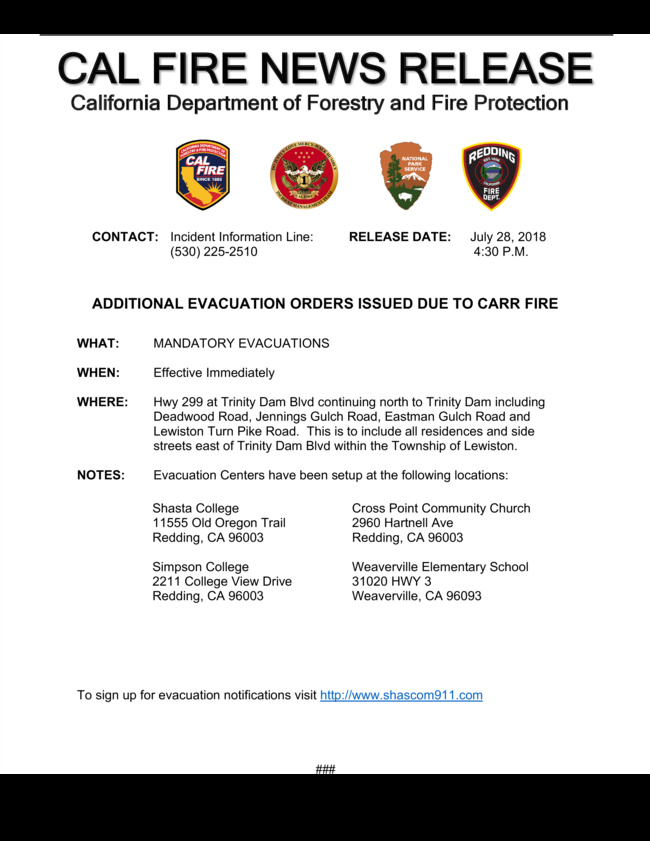
New evacuations in Lewiston, east of Trinity Dam Boulevard:
Folks please keep this forum to incident information. NorCalscan is doing a fantastic job with communicating. Questions and conversations are for the CARR??? forum.
9 Likes
For the Lewiston evacs, not to diminish them because we need to respect and act on every one of these orders, they pulled the trigger because fire made it to a certain point where they earlier agreed upon to pull it. However conditions on the ridge around County Line Rd, at the moment, sound pretty favorable with the winds out of the west.
With that, fire had made it up into the old Highland Fire from a few weeks ago. This is up Highland RIdge Road area. With the same northwesterly winds now, fire is pushing south back toward Trinity Mtn Road in Div H, looking for a strike team from Div M to come down and help with structure protection.
edit: to clarify location - French Gulch area and north French Gulch.
3 Likes
RICC did tone out a fire near Pine Cove (by Lewiston). Wildweb put it at 1/4 acre. 40 47.748, -122 46.146
Getting intel from boots on the ground in Igo, earlier today the fire was hung up in the east side of Zogg Mine Road area. Trying to pick it up. Now sounds like it slopped over Zogg Mine Rd and trying to pick it up with some firing ops down toward South Fork Road.
addition from boots on ground in Igo area: Small piece backing into Clear Creek off of diggins road. Trying to get check line to Clear Creek before dark. The Placer corridor looking good.
6 Likes
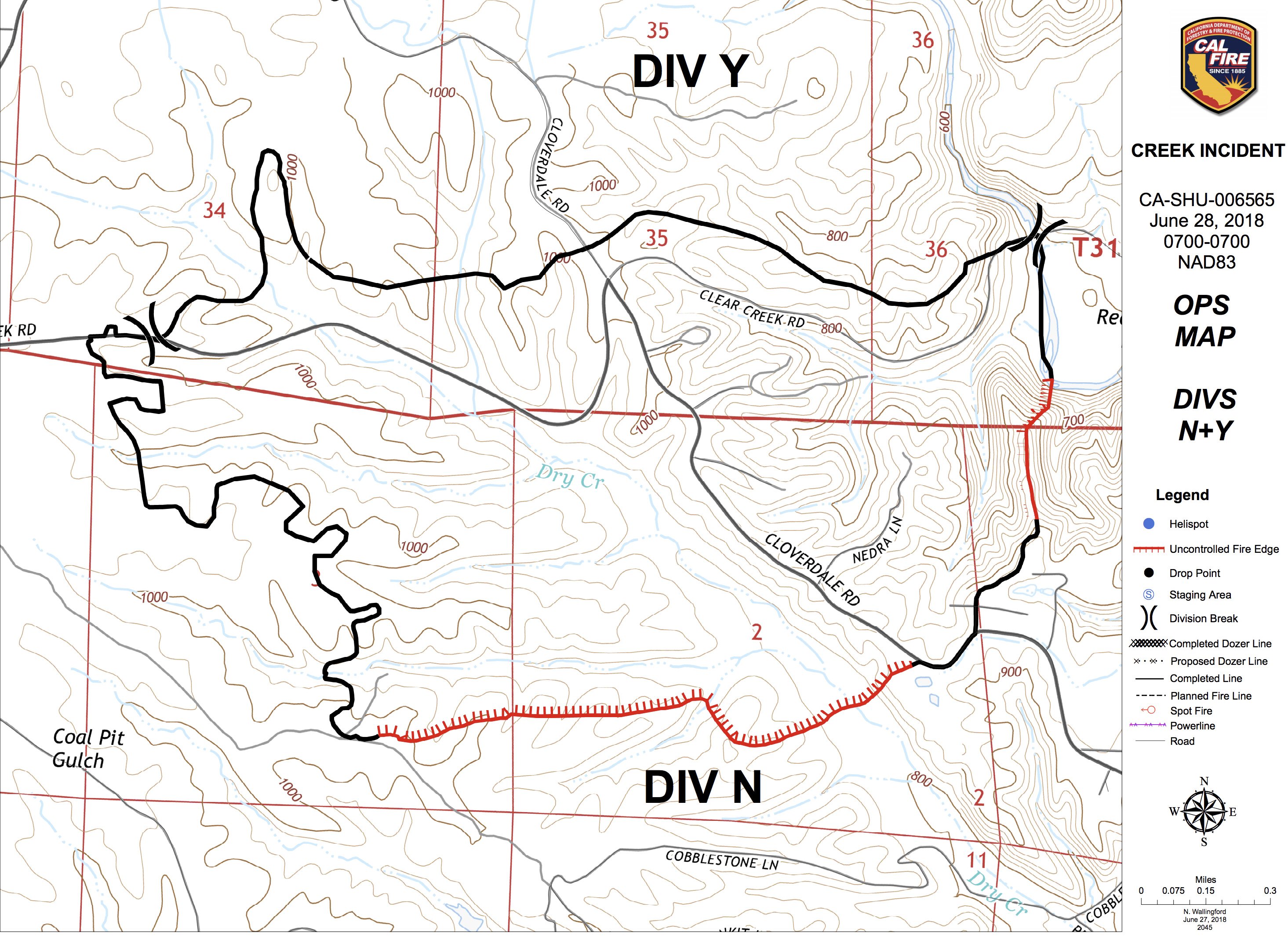
2200 update: from boots on the ground in Igo (one of our own), "Cloverdale Rd blacklined mostly from Placer Rd east to the SHU-Creek fire black from late June. The piece backing into the clear creek drainage is lined, and a contingency (is being, or has been) built from the SHU-Creek black on up along Diggins Way. "
The SHU-Creek black is one of the many recent scars this will get hung up in and stop/slow it down if it tries to make its way into Happy Valley area. The snapshot below is of the last Ops map for that section of the Creek Fire from June 28th.
9 Likes
2245: not much large intel to share for this last post. Tiny bits here and there. They are doing a lot of iron work on County Line Road up there in Div C, not sure if north or south of 299, I believe north to Hoadley Peak. I believe I heard a FOBS being told to leave the County Line road south of 299 by way of back roads into Douglas City (up and over Bully Choop and then Indian Creek Rd) since the exit out to 299 was impacted. I think winds have been favorable for them to attempt the iron work on that ridge north of 299 at Buckhorn.
Have not heard much from Highland Ridge Rd situation outside French Gulch where they were doing structure protection in the community again from a finger of fire that wrapped back around in the winds. Even further north on Div H there is a pretty good run up to the County Line (well north of Hoadley Peak, on the trinity side it would be opposite Papoose and Little Papoose Creek area). Not sure what has made it to the top, slopped over or what, but I know it’s hot and active.
We saw the boots intel on Igo a few posts earlier. They got a couple T1 copters in this afternoon to pound out hot spots in the same place they were yesterday along and north of Placer in the Centerville area. Only fixed wing action they could get today was retardant around Hoadley Peak repeater site.
USFS IR platform just flew over a few minutes ago - went over LNF-Whaleback and now heading back home it looks like.
KRCR TV7 shows more and more live video of homes on the Redding side of the fire that have massive wind damage, uprooted trees etc. Reports of debris falling like rain all over town. It’ll be interesting to see what comes out from further studies of the WX that happened Thursday evening.
I’m talking too much, see ya in the morning.
18 Likes
Last night’s IR:
IRIN’s Log (good info here):
KMZ for Google Earth:
https://ftp.nifc.gov/public/incident_specific_data/calif_n/!CALFIRE/2018_Incidents/CA-SHU-007808_Carr/IR/20180729/20180729_Carr_IR.kmz
Today’s IAP:
Ops Map:
4 Likes