
AA15 ordering one more tanker for Smith Ridge? Dozer line support work… might be kinda long wait with the new SQF- Summit incident.
3 Likes
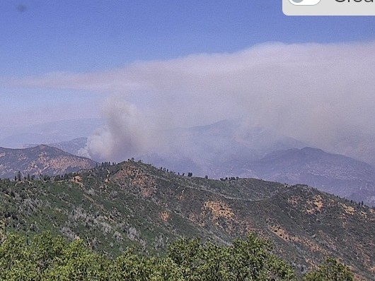
Still looks to be active on the run for that slop
2 Likes
It has been a while but I believe Smith Ridge runs SW below Fence Meadow Lookout (36 57.6528, -119 10.5400 should get you in the area of the lookout). There were lines constructed from the Secata Ridge area east of Big Creek Cove up to Fence Meadow during the Rough, I believe Smith Ridge is in that area. I imagine they are throwing a lot at the western edge of this to keep it from pushing toward the Blue Canyon area and upslope towards Dinkey Creek.
5 Likes
On Day two they were taking amongst the command and ground equipment guys that know that area’s behavior about it running up Dinkey creek drainage.
3 Likes
Having fought fire in this area for over 20 years and knowing some of the Sierra guys on the ground, that makes sense to me. Stop westward progression toward the higher populated areas and rock it out. Challenge will be to keep it from chunking off ground toward the south fork. I was in Hume the day it jumped the south fork and we burned Hume Lake Rd to the lake and brought fire down from the fires edge to the lake on the south end the next day. Steep hot country in the bottom of that river drainage.
2 Likes
Sierra guys as in E51-52? I was in North Fork back in 94.
4 Likes
I’m sure this will hit the SRA soon and FKU will shut it down quick. Rough Fire V2
4 Likes
Tankers 16 131 132 and 911. AA is 410 and 505 is the lead. Getting a free flyover in meadow lakes.
2 Likes
Saw a few dozers heading up 168 straight to the fire and one cattle hauler has had a busy day making a trips up and down the hill.
4 Likes
Where are they going to attack the basin fire from 168
2 Likes
Pushing a lot of indirect dozer line and painting it. Hopefully we can get an ops map.
3 Likes
Im sure someone is possibly thinking they will fire off Burrough mountain again(not me) I think were heading for Peterson rd to blue canyon or dinkey creek to the 10s69 road. I didn’t see them at mountain rest anyways.
5 Likes
AA and Lead said fire crossed over the dozer line and is backing down the ridge on the backside of the ridge they are working. They are building retardant below the ridge to keep roll out from droping into the canyon.
I believe that is the 11S02 road.
5 Likes
3 Likes
Transports are not able to access up from Trimmer Springs road very far or on Peterson Mill Rd. Best route in is up 168, through Dinkey and then down from Rock Creek.
4 Likes
@matthew3474 the ops map is on the NIFC FTP and I make a TAK data package daily and CAL-FIRE flew and mapped it this afternoon. I posted in the continuing incident thread.
6 Likes
Sweet thank you
1 Like
The fire is now very visible from tollhouse and pine ridge. Had a few people calling it in.
6 Likes
Column rapidly building in Rancheria creek.
3 Likes
5 acres air on order
4 Likes