A post was merged into an existing topic: CA-SNF-CREEK???
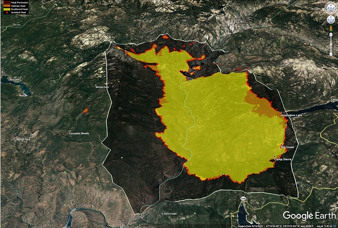
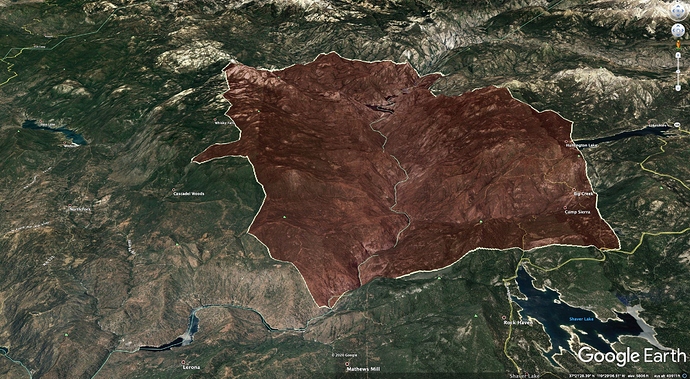
For comparison, here is the rough satellite (VIIRs) heat perimeter (3am 9/6/2020) in black with the 10pm infrared mapping from 9/5/2020 in red and yellow.
Units are starting to do some defensive firing operations at the “switchbacks” I believe they are talking about Highway 168 at the top of Stevenson Creek. They are talking about sending downhill traffic down Rock Creek road, which ties in to Dinkey Creek. Sounds like they are still working to evacuate a lot of people above Shaver Lake. (Florence Lake, Huntington Lake etc)
Yes, the ones usually referred to as the “switchbacks” were the switchbacks right at the base of the dam, at the top end of Stephenson Creek
That’s what I was thinking. With the potential of spotting to the East and every direction at this point this is getting squirly. Not a fast road either. I would think of dropping trailers and Moyer homes at China Peak, hunker down for the next 24 hrs. Plenty of room in this parking lots for civilians. Not perfect but safe.
Also new start in MMU
It’s crazy they have not punched the evac button for wishon and courtright. If people start down rock creek and shave is impacted. Rock creek to Providence to blue canyon would suck.
Yesterday’s run was really terrain-driven. The fire ripped 18 miles right up the San Joaquin River Canyon. Here is a cleaned-up perimeter without the inaccurate VIIRs points.
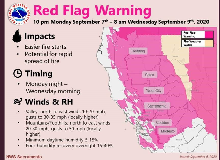
It has not finished running the north-facing slopes between Shaver and Huntington Lakes, but is out of slope alignment now on the west flank, and hopefully we’ll see slower spread going downhill to the west. East winds remain a huge threat, though, now that we have over 12 miles of active perimeter on the west flank.
Tons of potential for more terrain and wind-aligned running to the east NE of Mammoth Pool…
Evacuation order for wishon and courtright issued. Evac order for everything west of cressman store along auberry Rd to powerhouse road
Santa Clara County punched out an immediate need Alpha strike team - in route now.
XSC2301A - E65 Palo Alto, E187 Milpitas, E14 San Jose, E76 Santa Clara County, E152 Mountain View Fire
Listening to command. Talk of 120 persons at China Peak Ski Resort (east of Hunnington) needing evacuation. Operations discussing with Air support whether ground or air is appropriate.
There’s a Guard Copter enroute to fly out the China Peak campers at the parking lots.
One or two spots have crossed hwy 168 onto the south side into heavy fuels, slow spreading.
Thanks apx8000. Wasn’t sure how it concluded. That’s a hell of a rescue mission.
Makes you wonder when they are going to start releasing strike teams from the lighting complex fires and send them to either Bass Lake, Alpine or BDU for those fires
An hour or two ago the fire was working south towards the "switch backs"of 168. Given now there is some spots on the south side the fire is impacting the hwy to the point passing through in a vehicle quickly would be possible by trained fire fighter only. That’s probably why the guard ship was launched.
The switch backs are a few miles from china peak, looking at the map. Maybe up to 5 miles away.
Growth is slow to moderate so the folks at china peak have the rest of daylight to evac.
Just my 30 years of doing this wildland stuff opinion.
Makes sense
Santa Clara County XSC2303A punched out immediate need around 12:45 today as well. (E16, E68, E90, E97, E180)
And it is really hot up here in the lower elevations!!


