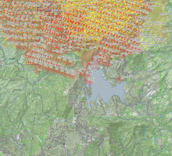
That sir is scary!
if you look at one yesterdays video posts you will see it at the left of the screen. Even at that distance, reported 10 miles, the spot was being drawn beck to the main fire. Than is scary!
Now that’s some long range spotting and then the picture of the bark that was being thrown that distance.
Will the lack of clean-up before make this burn so hot as to “sterilize” the soil ?
I’ve been wondering about the “Spot” fire - could have simply been a “clear-air” lightning strike off the column?
Just a thought… May as well throw in yet another crazy thing for the boots to consider with what seems to be quickly becoming the new norm.
Remember back when a few thousand acres was a big deal?
Ugh…
I’ve seen really erratic fire behavior based on large bodies of water and their influence on local weather. My father calls it “the lake effect”. Sudden wind shifts in the afternoon with instability causing extreme fire behavior and sudden wind shifts with fire tornados around the areas of the lake(s). I think Shaver Lake will do this today.
Lake effect mixed with the effects of heat on granite. Perfect storm condition
We saw a lot of ‘spot fires’ in the Salmon River complexes of 2014 that were caused by lightning from massive columns. But I have also seen a smouldering piece of lodgepole bark the size of a skateboard fall onto a briefing 12 miles downwind of a huge column in Central Idaho.
We have a place south of shaver in the Ockenden Ranch area. I was wondering how far it has reached as well. Local reports from over an hour ago state Kens Market was on fire.
Any legit reports of structures lost in shaver or the communities south?
No, the pyro cumulus didn’t develop until after the spot merged back with the main fire.
The spot h2o is referring to on peckinpah mountain hadn’t merged with the main fire at 6am this morning and the pyrocumulus was there before the spots at kinsman and cascadel happened.
Do you have a link to that map?
I pay for a membership that only I can access. Here is a link to the CalTopo site. I highly recommend. It’s a great site. Especially if you know how to add layers. https://caltopo.com
Anyone have link to interactive evacuation map for this incident?
Just saw a good video of operations at the point. The guys look pretty relaxed and smoke is sucking in good with little crowning. Unfortunately they don’t turn the camera on the houses. You can find it on this page and make your own call. https://www.facebook.com/groups/1222853964433269
Stay safe buddy
The article dated 2017 is still further behind in the real world! Trees have been dying and left to rot for many many years! More than Just a drought problem … Thank you for sharing the article …
In 2016 I served on CAL-FIRE IMT 4 (DERUM). We were charged with creating a response framework for the problem with Tree Mortality. I had the honor of working on this project with some talented folks from all over the state. I remember taking a recon flight over the western Sierra’s and it was astonishing to see. That was 4 years ago I cant even imagine it now. One of the product we created was a response briefing guide and map for all the units affected by tree mortality. I logged in to check to see if these maps still existed in digital format. These are the digitals we sent to the printer. They are meant to be folded but they have some good info. Here is a link. Tree Mortality

