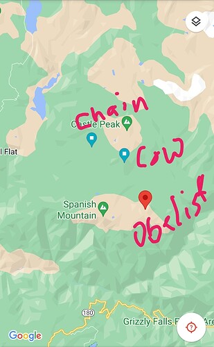
It’s near cow meadow southeast of wishon, 15 also spotted a smoke in kings canyon.
yeah the smokes on wildcad
contained per wildcad
This morning AA15 flew the SNF and reported the Fish fire has doubled in size. No acreage given. INF has the management of it and will not be staffing it. Reported as continuous fuels to support further growth.
Edison contained per wildcad
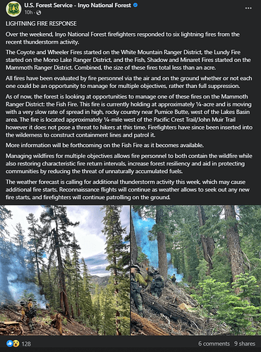
Inyo NF hoping to manage the Fish Fire. As of last night it was 1/4 of an acre, 1/4 of a mile west of the PCT/JMT, with a very slow rate of spread in high rocky terrain.
AA15 enroute Rodgers Ridge for smoke check, South of Wishon Reservoir.
@16:20 nothing on Rodgers Ridge… heading for Black Rock Reservoir on another smoke report.
Fire Watch 51 flew the SQF and has exited the air space finding no smokes in the Sequoia
forest.
@16:40 raining over Black Rock area (so no go there) and flew the Cow Fire with no smoke showing off of it.
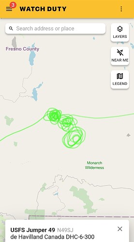
I believe the conversation with the BC and AA that there are suppression crews enroute to the Cow. Jump 49 (N49SJ tail - out of Tonopah) is now on scene and inserting crew in meadow below the fire.
AA15 reporting new fire near Obelisk Peak - maybe called the Obelisk fire having the jump49 insert crew currently. Crews on 167.475 AG 41 freq. with AA15
Jump49 will have crews on the Cow and Obelisk fires.
AA15 has a 3rd new fire 2miles west of the Cow. Jump49 will also be staffing this new fire in heavy timber.
not finding Obelisk on wildcad
Cow and Obelisk are confirmed waiting on name for the 3rd one west of Cow. I am not taking down the Lat and Long.
3rd fire is “Chain” fire. All on SNF around Wishon.
Jump49 out of Tonopah, NV. 10 jumpers.
Jump 49 is a crew of smokejumpers?
there’s a Redwood and Kern on wildcad.
edit those are actually down by Sequoia NF
APX this is that other start you mentioned earlier. Named the “chain incident”
The black waypoint is for reference
Finger crossed they catch it. I spend some time over there. It is in the rough burn scar that’s almost 10yrs old.
Edit: just on the edge of the rough fire
they just updated an earlier smoke check on wildcad to Obelisk
Jump49 is the plane. In this case it has 10 jumpers on board. They can drop all, or small groups, depending on their assessment of the needs of the fire. Then the senior jumper becomes the IC on a given fire. Funny to hear them call each other by name on the ground. And “Jumper Smith is XXX IC”.
Another cell heading for all 3 fires
They would get around to it once they get them mapped.
Obelisk has 3 jumpers, Cow has 2 jumpers and Chain has 2 jumpers. All are long hikes in and will report size up’s if I catch them. Jumpers are on SNF fire net 172.225.
Jump49 (N49SJ tail - out of Tonopah) if your looking at air radar. Enroute Fresno for fuel and maybe RON at Fresno to.
AA15 has a 4th fire/smoke he’s heading to.
@18:36 AA15 is north of Huntington Lake over the 4th incident. 37 16.73 x 119 12.37, 40x40 ground fire in the Creek Fire burn scar.
Obelisk peak is right on the border of Kings Canyon National Park and the SNF.
the flight path of the Jump plane shows the area of Hoffman peak, Castle Peak and Obelisk Peak, so anywhere between those 3 points are where the fires area.
4th fire is the “Line” fire by Huntington lake.
40 x 40 ground fire in the Creek scar.


