CA-SNF-Lions

https://inciweb.nwcg.gov/incident/5850/

Basic Information
Current as of 6/26/2018, 7:51:39 PM

Incident Type Wildfire
Cause Lightning Strike
Date of Origin Monday June 11th, 2018 approx. 12:00 PM
Location 7 miles southwest of Mammoth Lakes.
Incident Commander Stephen Fillmore, Type 3 IC
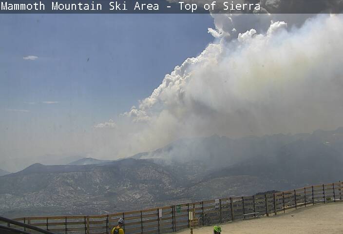
Incident Description The Fire Is Burning At Approximately 6000- 8000’ In Red Fir (compact) Needle Cast And Brush.
Coordinates 37.571 latitude, -119.118 longitude

Current Situation
Total Personnel 266
Size 2,959 Acres
Estimated Containment Date Saturday July 14th, 2018 approx. 12:00 AM

Fuels Involved
Timber (Litter and understory)
Brush (2 feet)

Significant Events
Moderate Flanking
Isolated Torching
Short-Range Spotting

Outlook
Planned Actions
Crews will continue to scout, construct, and burn out fire lines utilizing natural barriers to the extent possible. Utilize helicopter water drops to check fire in inaccessible terrain north and west of the San Joaquin River.

Projected Incident Activity
Continued spread to West and North especially in thermal belts with poor recoveries and in dry fuels. Downslope winds may push fire further south in the San Joaquin River.

Remarks
1,883 acres on the Sierra National Forest; 1,076 acres on the Inyo National Forest.

Current Weather
Weather Concerns
Hot and dry conditions continue into mid-week. An incoming low pressure center will increase winds Wednesday, similar to what occurred on Monday. Afternoon temps in mid-80s, RH in mid-teens, and afternoon winds SW 10-15, gusts to 35.

1 Like

TFR for Lions Fire

Issue Date : June 23, 2018 at 1758 UTC
Location : 6NM SOUTHWEST OF MAMMOTH LAKES, California near FRIANT VORTAC (FRA)
Beginning Date and Time : June 23, 2018 at 1840 UTC
Ending Date and Time : September 23, 2018 at 1039 UTC
Reason for NOTAM : TO PROVIDE A SAFE ENVIRONMENT FOR FIRE FIGHTING AVIATION OPERATIONS
Type : Hazards
Replaced NOTAM(s) : N/A
Pilots May Contact : OAKLAND (ZOA) ARTCC, 510-745-3331
Airspace Definition:
Center: On the FRIANT VORTAC (FRA) 022 degree radial at 35.8 nautical miles. (Latitude: 37º34’12"N, Longitude: 119º07’35"W)
Radius: 5 nautical miles
Altitude: From the surface up to and including 12000 feet MSL
Effective Date(s): From June 23, 2018 at 1840 UTC To September 23, 2018 at 1039 UTC
1 Like

3300 acres and 7% contained.

2 Likes

3850 acres, 50% contained.

1 Like

4064 acres, 90% contained. Crews working on suppression repair and monitoring any spots.

2 Likes

100% contained.

This thing is awake and running!
https://www.mammothmountain.com/cams/summit-cam

1 Like

Well…I pulled the contained off the Title. Continue here with updates.

AA and H520 are up flying the fire now, Have been since mid afternoon at least.

1 Like

Just starting to show on the GOES-16 fire temperature loop:
http://rammb-slider.cira.colostate.edu/?sat=goes-16&sec=conus&x=682&y=3763&z=4&im=24&ts=1&st=0&et=0&speed=130&motion=loop&map=1&lat=0&p[0]=20&opacity[0]=1&hidden[0]=0&pause=0&slider=-1&hide_controls=0&mouse_draw=0&s=rammb-slider

1 Like

Helicopter 532 and HT-43T from the Angeles are committed to this incident today, along with an AA.

Looking at Mammoth Summit camera winds coming out of the WNW, could see a column building but appears to have been sheared off and now starting to decrease visibility. Heat signature as well is starting to show on GOES West IR

They had a few copters on this yesterday with air attack again. Same area so with your info I am assuming it was the same fire and not a new start.

1 Like

This thing is putting off a lot of heat tonight.
http://www.ssd.noaa.gov/goes/west/wfo/hnx/h5-loop-ir2f.html

Looks windy up there.

Quite a Pyrocumulus buildup

Weather is saying thunder storms possible today. Inciweb is reporting 600 acre growth yesterday and using rock walls to box it in along with hand lines being worked with crews and copters. I can see mountains though on the webcams today compared to days passed though

2 Likes

They are getting a lot of lightning in the area right now.

1 Like

Tankers 76&78 are heading to a fire in owens valley.

1 Like