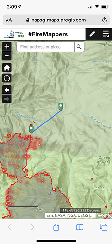
lot’s of lines painted this afternoon. Hoping for the best
What sections of the fires were they making retardant drops? Seemed like good air today, and nice backing fire on the north west end. Hopefully tying in that Dennison Ridge area above the south fork.
Multiple drops across Blue Ridge in front of the communications equipment.
With the fire starting to burn in the park the team will not have much options on controlling the Western edge due to restrictions. The end result will add a substantial amount of acreage to the fire. My guess is the fire will end up being well over 200,000 acres.
What restrictions might those be?
Currently the team is building dozer line on the forest and private property but will not be able to due that on the park. Unfortunately there are not enough crews to go direct on the line so that is why it will get significantly larger.
It would mean that the fire must be going into the wilderness and that means looky but no touchy so to speak. No mechanically powered type of tools or equipment. Hotshot crews only. Correct me if I am misguided.
In theory…
But I’ve seen dozer line be approved in Yosemite
Just depends on the park
Although this is my 25th fire season, I am constantly learning about these restrictions. Our family has owned land within the park (silver city) since 1934, so I’m fairly familiar with the area.
My understanding is the “Golden Trout Wilderness” is south of Dennison Ridge. “John Krebs Wilderness” does not begin until Horse Creek and the area north of Evelyn Lake. This would leave Hockett Meadows and the land to the west going to south fork as un designated.
With that said, I believe there can be some good suppression efforts to be had along the sparse fuel beds of Hockett Meadows.
Feel free to pull up a satellite and topo map of Hockett meadow. With all the granite to the East, sparse well managed fuel beds, and miles of meadows. It’s pretty much a shot crews wet dream. Hold and camp…
Not the expert on tactics, but the lack of dozer line is not solely about park or wilderness designation. Section 4(d)(1) of the Wilderness Act allows wide latitude in fire control, including the use of motorized tools and equipment.
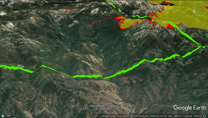
The terrain of the upper South Fork Kaweah is steep and rocky. Even on the BLM/SQF lands I don’t see any opportunities to put dozer line up the side of Dennison Peak (park boundary in green).
Excellent graphic. Although dozer lines do a hell of a containment job, they certainly aren’t the end all be all. Let’s remember that it took over 3 days for the fire to make this 1/8 mile progression north. Granted I don’t want to see this get established in the south fork, the fire certainly isn’t making a ferocious run to the north. With cooperative weather and good air to work with, I believe some good work could be done with aircraft and crews.
In my opinion, the biggest threat will come from down canyon winds at night.
I know it’s no comfort to those evacuated, worried about homes and businesses, or eating smoke, but fire is getting back into a sequoia grove that hasn’t had any since 1985 or earlier. We can hope that fire backing down from Dennison is doing some good and not too much harm to those old trees, and making that area safer for the future.
I guess I didn’t see this this morning. Is this thing actually spotting 2+ miles ahead of itself?
Fortunately, this spot seems to be surrounded by granite
Wouldn’t surprise me.
Last weekend it was spotting 3 or so miles out.
The winds below Springville were blowing earlier today when I left the house.
And they just issued further evacuations in that area.
I understand that, but yesterday’s winds didn’t warrant that. Hopefully it’s just a glitch.
Any IAP link? Would love to see the plan.
Thanks
Agreed. Winds were pretty mellow yesterday.
And I haven’t come across an IAP link today, so I’d love to see that too!
SQF-Castle IAP complex:
SQF- Castle FTP files: https://ftp.nifc.gov/public/incident_specific_data/calif_s/!2020_Incidents/CA-SQF-002622_SQF%20COMPLEX/


