Here is the link to the daily IAP. SQF Castle IAP
Thanks for the IAP
Thank you.
Down canyon winds in South Fork tonight
https://caltopo.com/map.html#ll=36.29631,-118.76375&z=12&b=t&o=f16a%2Cr&n=1,0.25&a=modis_mp%2Cwxd_wspd-01
This is the typical pattern and biggest fear. As the valley floor cools, winds switch down canyon. Hopefully not bringing fire brands with the breeze to a more receptive fuel bed.
Hopefully nightfall doesn’t lull us into complacency…
IAP 09/19 - 20
Flyron, thank you
Any intel on that “spot” by Grouse Peak. Was it a spot or a new start. Seem somewhat suspicious that it started right off grouse valley rd.
Any word on containment of that spot?
It’s the planned firing operation.
Wow! Thanks for the insight. It would be interesting to find out how that ties in with the bigger picture
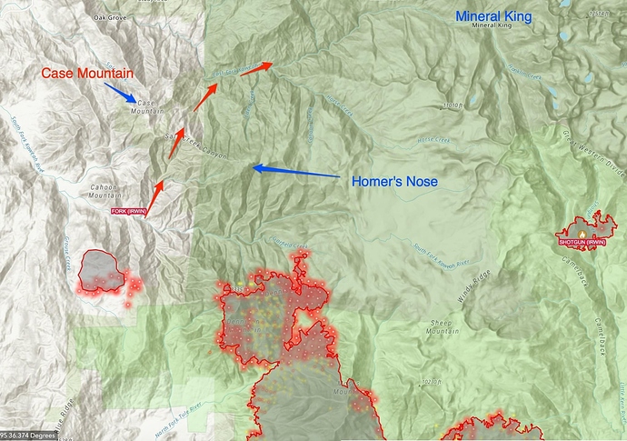
I don’t have any inside knowledge, just looking at OPS maps. South of the South Fork the maps show primary containment along the Grouse Meadow Road back to the North Fork Tule which was what was being fired. Not sure what the plan is north of the South Fork, but it looks like using the Cinnamon Gap Road and the ridge between Case Mountain and Homers Nose as primary.
I live and ranch in the upper South Fork. They won’t be using the old Salt Creek fire control road East (northeast) of the Mt Rd 319/ Grouse Fire Control junction (runs parallel to Bennett and Cahoon) to tie into upper Cinnamon and eventually Case Mt. They can’t get equipment that far up the road, which narrows to 10’ in many places. Seems they’ll likely tie into the existing dozer line they put in on the 190 acre Fork Fire earlier this summer, along Cahoon Mt. I saw mention of using hand crews to tie those in from S Fork Dr, likely at the 319 junction. There’s an old road mining OHV road that climbs the southwest portion of Cahoon.
Makes the most strategic sense to use the earlier burn on Cahoon and draw the line at the bottleneck there. That’s where the town of 3R drew it’s Urban Development Boundary for a reason: the canyon above that line turns into a steep V-shape canyon with a big burn history, dry fuels, some mixed chaparral on the south side of the river. Salt Creek Ridge is a 10’ tall, impenetrable chamise and mt mahogany stand for miles up to Case Mt and it would be paramount to stop it on the south side of the river.
My 2 cents in the bank 
I agree FireGaucho. Seems like a risky proposition to have fire established in the south fork.
My family has had property up in Silver City since the 1930’s. Scary to think if it burnt up to homer’s nose and case, it could easily get established and run the East fork.
Not to mention what was once a green forest canopy on top of Case has been decimated by bark beetle and drought over the last few years.
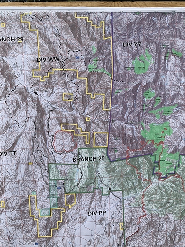
Take a look at the proposed dozer line in WW.
That’s some legit work. Any mention if that’s a contingency? Kinda scares me to think they’d fire from that…
Unknown just sharing the map-
dang, that’s some rough country to putting in a dozer line. More power to them!
The heat is picking up in that area again, getting that fired off will button up a decent chunk if all goes to plan.

