Overnight mapping shows:
10,489 acres for the Trout Fire (increase of 1,768 acres since previous flight)
8,661 acres for the Long Fire (increase of 4,592 acres since previous flight)

Overnight mapping shows:
10,489 acres for the Trout Fire (increase of 1,768 acres since previous flight)
8,661 acres for the Long Fire (increase of 4,592 acres since previous flight)
Trout still showing heat. Long less.

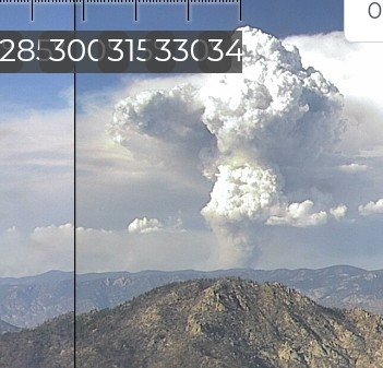
Looking at Google Street view images fuel sparser in the manter scar so the long fire lost its legs, that explains why it went from a big pyrocb to hardly visible yesterday afternoon
That’s pretty much what was being said during the meeting at KM. They basically have two options in the scar areas 1. Hit it with air resources to give the hotshots time to get a handle on it/ use it as a natural break or 2. Watch it burn hot and fast with the wind. Unfortunately, the past few day the second option has been the only option in the afternoon.
They’ve been hitting it as hard as they can with LATS and MAFFS 2,4,6 when they can.
Curious Fire activity around Bald Mt Sequoia 2 cam has been pretty active today. I’ve seen vehicles and personnel at times al afternoon around the tower and a few times saw people walking the steps up to the tower?? Anyone hearing anything? Prepping??
They have hand line going across bald mountain and are taking it east.
Tankers are hitting the ridge running n/s above the 22s19 to Sherman pass road on the west side of the fire.
Helco diverted to LNU Ridge

It’s cousin is doing the same on the Plumas. Both are pretty impressive!
The 6 hour time lapse is a good display of how fire influences local weather.
https://ops.alertcalifornia.org/cam-console/2378
There’s a new fire south of kennedy meadows east of sherman pass road. AA did a few passes over it before returning to Porterville.
35.953000, -118.061
Looks like the Bald Mt cam on Trout went down about an hour ago. I know they’ve had some rain and lightning up there this afternoon.
Renee is what it’s named now.