From North Ops 1800 update 8/1/2021:
200 acres brush and timber, 1% contained with a moderate rate of spread. Threat to structures, communication infrastructure, wildlife habitat, cultural and historic sites. Fire is burning near the Marble Mountain Wilderness.
4 Likes
951 acres brush and timber, 1% contained. Moderate fire behavior today with isolated torching. Threat to structures, Ukonom Mtn. Lookout, communications infrastructure, cultural and historical sites of the Karuk Tribe, public timberland, critical fish and wildlife habitat. Smoke impact to Class 1 Airshed. Portion of the fire is burning in the Marble Mountain Wilderness. Type 2 SW Team 3 (Gresser) on order and scheduled to inbrief Sunday 8/8.
2 Likes
2,116 acres and 1% contained
1 Like
Is it safe to assume hardly any action is being taken on this fire?
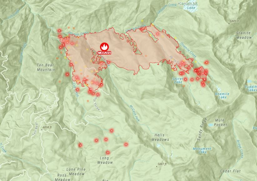
CA-SRF McCash Fire: 2,116 acres brush and timber, 1% contained. Active fire behavior with backing flanking and single tree torching today. Threats to structures, Ukonom Mtn Lookout, communications infrastructure, cultural and historical sites of the Karuk Tribe, public timberland, critical wildlife habitat, and to the Klamath River Watershed. Smoke impact to a Class 1 Airshed. Portion of the fire burning in the Marble Mountain Wilderness. Road area and trail closures in effect. Red Flag Warning Issued today until 11 pm for abundant lightning on dry fuels. Type 2 SW Team 3 (Gesser) in command.
1 Like
Just looking at Modoc Interagency Dispatch and they have had 60+ resource orders in 4 days from many of the Nor Cal fires that they had to UTF, including this one.
http://www.wildcad.net/WCCA-MICC.htm
Responds time for order fills are going to be extended.
2 Likes
There are a bunch of new VIIRS heat detections to the south of the fire, well outside the perimeter. Anyone have intel if this is a spot from the McCash or maybe a new lightning fire? I know there was some lightning in the Orleans/Hoopa area yesterday or the day before.
2,599 acres and 1% contained
1 Like
The McCash fire is growing significantly today, it will need to be watched as there is not much recent fire history on the west side of Highway 96 in this area.
5 Likes
3,936 acres and 1% contained.
A lot of growth potential today with the NE winds. The fire is pushing between other scars Haypress (2017) & Ukonom (2017). If it crosses the highway to the west there is plenty to burn as it last burned in the Klamath Theater (2008) and south of there no fire history in the last 30 years.
Evening update:
6,788 acres and 0% contained
1 Like
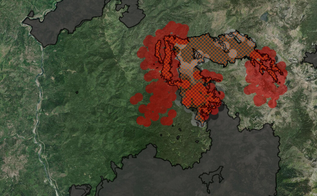
Big day on the McCash yesterday, and from the looks of the GOES17 IR, it’s been cranking all day today. Fire progression map, with yesterday’s growth in red:
6 Likes
11,171 acres
2 Likes
18,143 acres and 0% contained.
2 Likes
I find the SWA IMT 3 team has this fire and I don’t find an IAP posted to see the number of staffing on this incident. Was interested in the efforts the IAP would demonstrate.
Got the Map products.
I know in the past some teams deemed them confidential.
Inciweb has it as 19,707 at 14:00 Monday. No containment detailed.
I may be wrong but this might be one of the fires that they have no staffing on being in the wilderness for the most part at this time.
1 Like
The maps shows dozer lines in the west area of the fire. Hard to discern the use boundaries.
You’re probably correct given the resources are lacking.
2 Likes
Here is the resource totals from last night 209.
McCash 209.pdf (851.3 KB)
1 Like
I was the patrol here for many years and the fire is burning both in and well outside the Marble Mountain wilderness. Ugly topography, remote country and huge fuel loads. given the nationwide drawdown and lack of population centers near it, this fire does not stack up well against other fires for resources. I would suspect once it reaches the Highway 96/Klamath river line that might change. here is a map with a little better graphic of the wilderness boundary. Public Info Map August 12, 2021 - InciWeb the Incident Information System
1 Like
36,461 acres brush and timber, 1% contained. The fire has had a couple of big days. Happy Camp is now under Evac Warning.
From Will Harling on the “Salmon River and Orleans Complexities” FB group, yesterday:
The McCash Fire made significant runs into the headwaters of Independence Creek yesterday afternoon as well as east into the headwaters of Elk Creek, growing more than 6,000 acres. Spot fires have been confirmed just south and east of Norcross trailhead and along the ridge between Lick Creek and Bishop Creek. The spot fire near Norcross appears to be spreading rapidly from satellite infrared detections and has crossed Bear Creek and heading north towards the Stanza road system.
As of a couple hours ago, the incident management team thought they still had a chance of catching the spots on the ridge near Lick Creek with air support and initiating firing operations to stop fire’s spread on the west side of Elk Creek towards Happy Camp. The Smith River Hot Shots were preparing to initiate a burnout from Johnson Hunting Ground west along road and dozer lines to buffer the effects of an inevitable run out of the Coon Hollow fork of Independence Creek, however that was before the spot fire near Norcross was confirmed. If folks have more current intel on this please share it.
There has been an evacuation order issued for upper Elk Creek residents (see attached map of evac zones). The incident management team works with partners to set management action points (which show up as lines on the evac map) to trigger these evacuation warnings and orders. When the fire makes large runs it can skip the warning period and move straight to orders. This does not mean homes on Elk Creek are imminently threatened today, but that given the fire’s predicted and observed movement, it could reach homes within a short period of time. The McCash Fire has spotted nearly two miles on several occasions, and folks that remember the 2008 Panther Fire recall how that fire made a huge run out of the Marbles, down to Norcross and up to Buckhorn Mtn within six hours. There is currently no road closures for residents who need to get back into their homes on Elk Creek.
The Team is elevating requests for crews and resources given the potential for the McCash Fire to threaten residents in Elk Creek, along Hwy 96, and ultimately Happy Camp. There are not a lot of good containment features between the fire and Happy Camp, and the team has had minimal resources to do anything more than point protection. It doesn’t help that new fires like the Knob Fire near Willow Creek are also posing a near term risk to populated areas and requiring resources be stretched even thinner.
3 Likes
Hard to believe that the last post about this fire, from 18 days ago, had it at 36,000 acres. It’s over 84,000 acres per last night’s IR. Yesterday new evacuations were ordered for the Elk Creek area of Happy Camp after the fire jumped the line near Titus Ridge. It looks like the wind event pushed the SE end of the fire up the Wooley Creek drainage in a big way yesterday. That area of the drainage had a combination wind and slope alignment and no fire history.
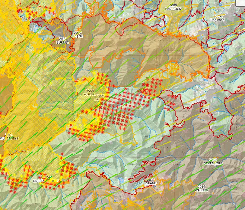
I suspect that some of those heat detections are from the column, but the clustered detections in a couple of places way out in front of the fire look like spots to me. Winds blew all night, and that puts it pretty close to getting into the Shackleford and Kidder Creek drainages. There should be significant rain over the fire starting soon, but then warm and dry conditions return later next week.
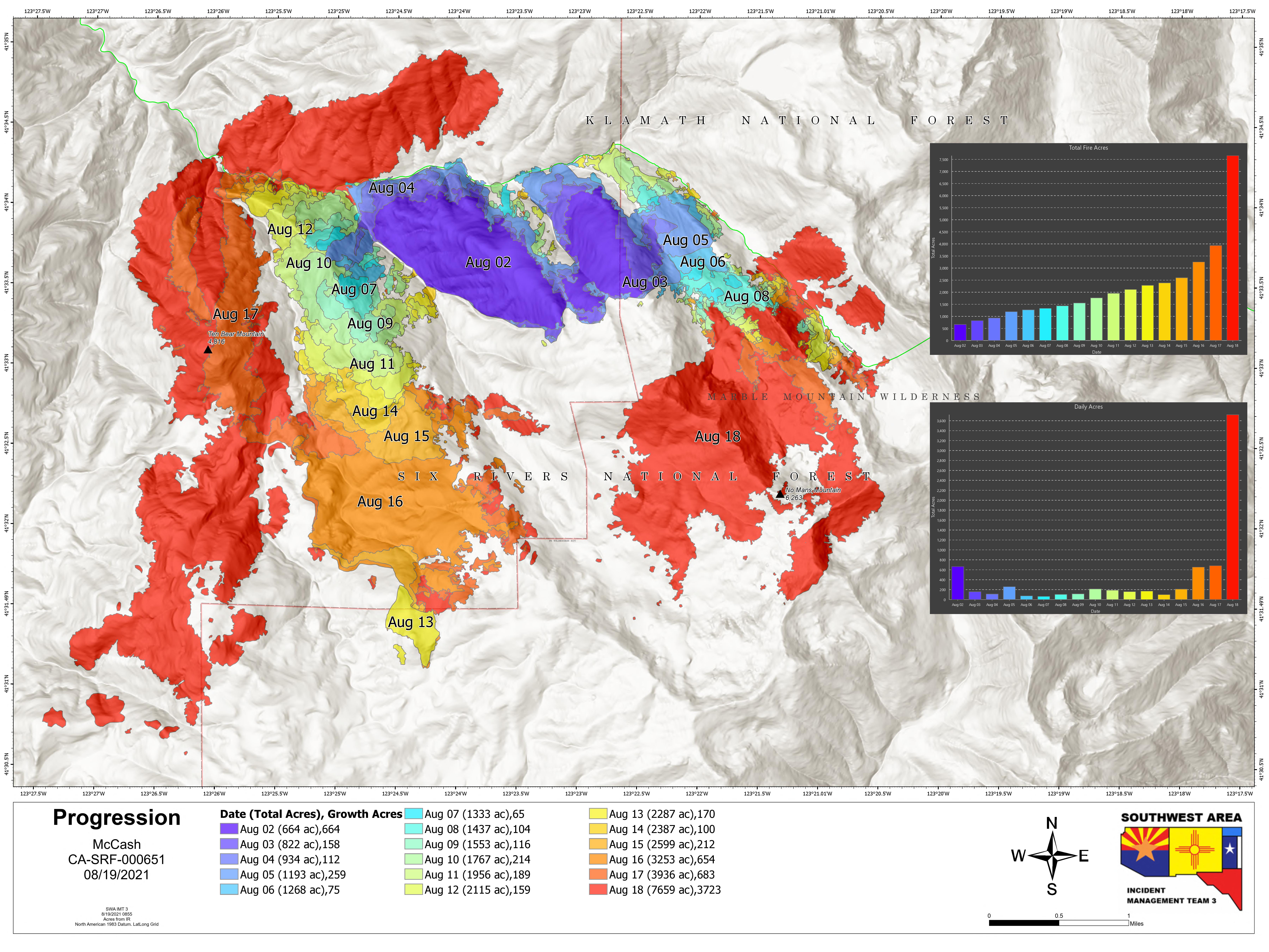
Progression map from a couple of days ago:
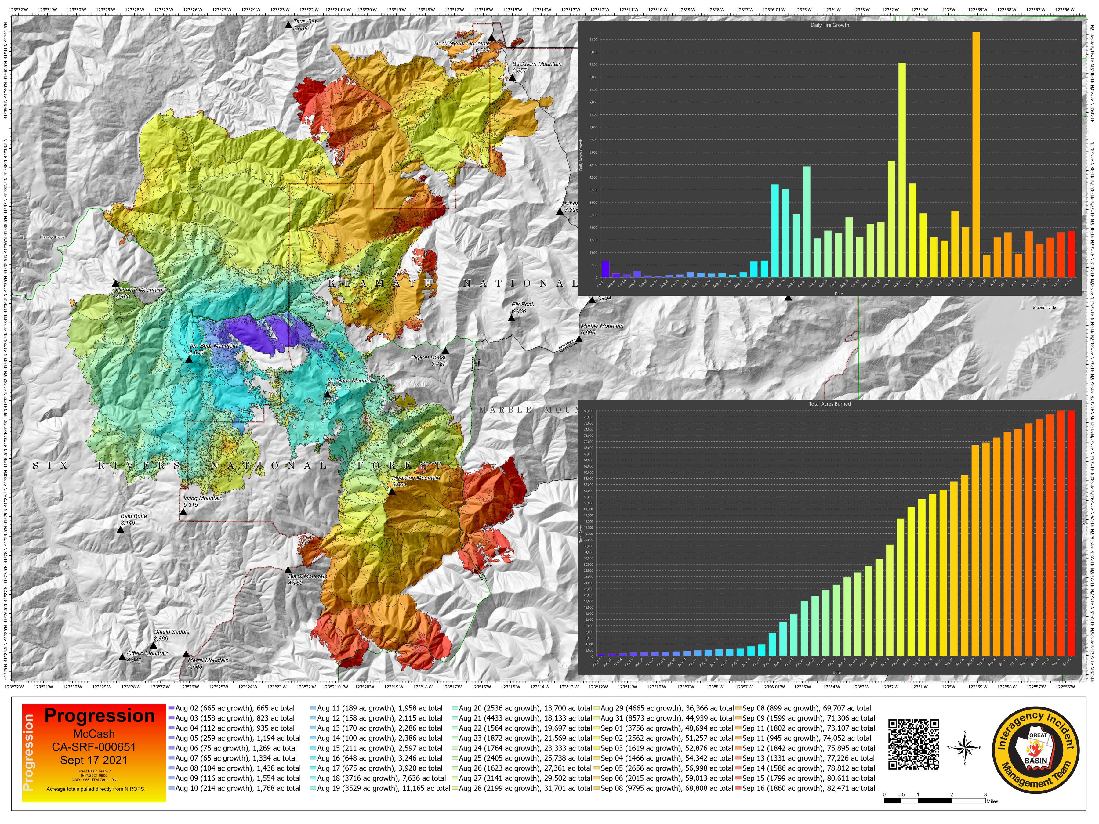
9 Likes