CA-TGU-Elkhorn (3-4)

State ID:CA
3 letter designator:TGU
Fire name: 3-4 or informally “Elkhorn” or “Pettyjohn”
Location: Elkhorn Ridge and down into Pettyjohn Road area
Reported acres: 2000
Structure threat: Yes
Resources: AA just requested 2 VLAT, 4 LAT, 2 T3 multiengine, and 4 T1 rotor
Radio channels: CDF CMD7, A/G Tac15, Air FM 164.1375, Air Victor 126.875
Scanner link: Above comm plan on scancal.org/live.html
Webcam link: Eighmy Cam

Evacuation Warning for the entire west side road system out there in Pettyjohn Road area.

Almost looks like another fire-nado on the 15 min loop

Rough sketch of the 3-4 fire on top of last year’s TGU-Red Bank Operations Map. You can see it squeezed in between last year’s South and Red Bank Fire. They are utilizing the dozer line system off the Red Bank. It did blow through the contingency line on the south end below Sec 22 there, down near the red Division X.

5 Likes

IR Imagery taken at 0230 Thursday morning. This is about what I imagined from yesterday’s radio traffic and fire behavior. I’ll stick the perimeter in Google Earth along with last year’s fire perimeters to see how it fits later this morning.

Yellow highlighted road is Red Bank/Lowery Road, with the red circle the intersection with Colyear Springs Road. That’s the only resemblance of civilization out here unless you’re a local.

Here is the IR perimeter for the 3-4/Horn fire, and then last September’s SHF-South in blue and TGU-Red Bank in green, both lightning starts also.

3 Likes

Per TCSO traffic, mandatory evacuations for CA Hiway 36 west between R Wild Horse Ranch and the Baker CalFire station at Bowman Rd and 36 West. And all roads south to Lowery Rd.

4 Likes

1200 Friday: (cut and paste from what I wrote for a community FB group I’m keeping up-to-date)

Incident name changed to Elkhorn.

They did not get an IR flight last night due to mechanical problems with the aircraft. So they are working blindly with 36hr old data instead of fresher 8hr data. I also can’t produce better maps to share either without that. I do have MODIS/VIIRS satellite hits that give a general idea to interpret, and correlate with radio traffic and ops maps.

Southeast edge along Sunflower area. They are pushing dozer line all along that eastern edge, from the old Red Bank Fire edge down to Panther Rock, cut over east to the Red Bank Road (the sunflower Red Bank Rd) near Montgomery Place. Then they’ll tie in to the existing Sunflower Trail dozer line from the old fire. I missed their plan on where they eventually tie it into the line further west, whether it’s direct, an existing dozer line, or eventually make it to Colyear Springs Road.

Southwest edge up Colyear Springs Rd to Elkhorn Peak. Fire behavior subdued now being socked in with half mile visibility on the line. Identifying and doing structure protection where they can back in there. According to MODIS/VIIRS satellite heat, fire appears to made it down to the South Fork Cottonwood Creek back behind Elkhorn but it looks like a backing fire (vs. a wall of flame).

Northwest edge – up Pettyjohn. Sounds like a forest service dozer and resources are working their way down the top of Tomhead down possibly Sheep Trail Ridge to the north. CalFire working a plan for cutting in from Saddle Camp up to Brushy Ridge, then tie into line coming out of the Rancho Rio Frio area, and then tie into line near Goat Hill. I was correct yesterday in my surprise that fire was reported at Raney Peak, which would have cut the distance nearly in half to Hwy36. Fire is indeed NOT at Raney Peak now, and is further south.

While they are hoping to cut that dozer in across the northwest, north and east across the fire over to Vestal, they are planning for the worse and prepping for fire spread further north to 36. It’s all about plans A, B and C. Shoot for A, hope for B, and build with ©ontingency in mind.

5 Likes

1300 Sunday Update:

IMT4 Tehama Zone Deputy OPS summary today on Facebook

Making some great progress on this fire but a long fight ahead of them still. SE corner is tied in with dozer line and then fired it all off down to Sunflower Jeep Trail. On the imagery below, you can see the backfiring started there at the top of the line late morning and worked their way down and completed early evening.

Lots of residences on and behind Elkhorn Ridge with engines and crews providing structure and point protection in there as fire works its way through. They’re working on plans to go direct and either stop it direct, or eventually tie it into 2019 South or chase it well into the forest and hope USFS can catch up.

On the north side they have some direct line and it’s holding I believe in most places. There is contingency line being scouted and put in further north to help protect R Ranch and any further spread north toward Hwy 36W and Platina. Pattymocus Butte radio site was prepped by C902 crew yesterday morning (TGU Tone 4) north of the fire. Some contingency line had to pause as they came across the PGE gas line that runs Red Bluff to Eureka. Waiting for PGE to arrive on scene to scout that out.

Inversion is just starting to lift in the lower side of the fire allowing a few rotor to get in the air. The west side is still socked in. Fire activity is also starting to immediately react to that inversion lift. Here we go.

The imagery below is from the Sentinel Satellite from EU Space Agency. It has a pass over the fire area at 1131am Saturday. I threw that into Google Earth, along with a perimeter product from the IMT. Not sure if that perimeter is NIROPS or Firewatch or DOD, not sure if we got a NIROPS over this incident. I also put in last year’s SHF-South and TGU-Red Bank to show their scars, and where Elkhorn is taking advantage of. Far right above the Sunflower gulch pond is where they started the firing ops down that far east line.

6 Likes

1500 Thursday
After a week of quiet subdued fire (but not enough resources to fully take advantage of that) it decided to wake up today as some smoke lifted, RH dropped, temps rose and fire got to see the sun. It’s starting to spot over some dozer line on Div A/X all on the western back of Elkhorn Ridge and making challenging runs and rolling out elsewhere along the line. Some CNG CH-47’s out of Red Bluff are working it where they can. The problem out there is once you lose the box on the west side, it’s a good distance to the next box (and becomes the Forest’s issue). At one point there was a request for fixed wing but either denied or cancelled after a visibility check. Smoke cleared enough to wake the fire up but still not clear enough for canyon runs.

Long dozer transports have to come up the M22 from Paskenta instead of up Colyear Springs Rd. That’s a long commute.

Everywhere else is heating up too, the Glenn Zone, MNF August Complex, and the Butte Zone. Everyone is starting to want the same air resources. Temps are only going to rise into the weekend, and further RH drops in the next couple days.

Edit as aircraft hit pumpkin: 40-50 acres slop on the west side (in DivA it sounded like). They started putting retardant on it directly and it was ineffective so they painted the ridge lines instead. Brushy Ridge (which leads me to believe it was A and not X) Fire was still extremely active at pumpkin. Crews on ground were able to punch line on a flank extending half a mile to the west of the fire.

7 Likes

Saturday 8/29 evening
They’ve basically got the bulk of the SRA portion tied up and are chasing it (it’s dragging them?) west into the wilderness. It’s still not solid on the very north end I don’t think but very close. They did complete a dozer line and fired off it up above DP30, Middle Ridge area to help hook it to Div B. They also have some stubborn fire they’ve been fighting all week on the back side of Elkhorn Ridge in the Sulpher Creek Drainage. Lots of resources in there the last few days where it got real got, keeping structures protected and going direct when they see the opportunities.

DRTI imagery off the MNF August, not sure what platform it’s off of. Taken this afternoon around 130pm, looking east and down with crosshairs right into the Sulpher Creek drainage. Elkhorn Ridge top center, the M22 working to the right along Valentine Ridge, and the spur ridge to the left ending at the red ARMED has the 26N01A road.

This is looking east down the south fork Cottonwood Creek Drainage with Tomhead Mtn in center, with the green 2019 Red Bank Fire (no factor here) and the blue 2019 South Fire. You can see a slop they had on the north side that they were addressing last night and today near Brushy Ridge. The white dashed line is the ridge where the Humboldt Trail is, and the boundary to the Yolla Bolla Middle Eel Wilderness. The fire is now about 500 acres into the wilderness flanking the crews up top, and continuing to try and spot back out of the wilderness further west, forcing the crews west to keep their northern containment. They have two plans it sounds like tonight for this. First they have ordered up around 6 Type 1 crews that they want to have chase this west till East Low Gap (bottom of white dashed line). Then they’ll hook this south along Long Ridge (black dashed) into the creek near Hawk Camp and western extent of the South Fire, and work their way east back up Tomhead Gulch to the top near Buck Camp. Meanwhile, second piece of plan sounds like running parallel just outside the wilderness also chasing this thing along the 27N05 and N07 road system, and doing low intensity firing ops back up to the ridge line.

6 Likes

Thanks, Norcal. Here is another look at how it is bumping other recent fires, with last night’s IR, looking east. The dark blue fire in the foreground is last year’s South Fire. The 2019 Red Bank and Ranch Fire straddle the east end of the fire, and 2008 fires are light blue.

We’ll likely get really good fire effects in the places this fire reburns the 2008 Fires (Iron Complex, Vinegar, Slides Fires - I would expect that many of the larger trees which survived those fires will survive this one, as well.

6 Likes

Mon 8/31 Just a quick summary for today’s operations on both Elkhorn and the northern bits of the Glenn Zone (Tatham and Doe where it threatens and bumps SRA.) Today is the first day we can see mountains from the valley. Clear air means a lot of things, higher intensity fire, higher temps and lower RH, but also aircraft get a clean shot at the thing as well. They have been approved for retardant operations in the wilderness where it supports direct attack on the fire only (as opposed to pre-treating a line ahead of the fire.) They were hoping to work all through the Tomhead Gulch and Sulpher Creek drainages today, however the air still isn’t quite clear in Sulpher Creek behind Elkhorn Ridge, and there are no terrain features to really take advantage of the retardant up in the wilderness area this morning and tying it into the Elkhorn Ridge area. Much more conducive for helicopters for the time being. Will try again this afternoon.

For the Tatham Fire south of Elkhorn, it’s pushing its way north to Riley Ridge. They have dozer line along the ridge but nothing past that at the moment. When the inversion lifts and the fire gets aligned with the terrain and slope reversal, they expect it to make a mile run at least today, in a generally N-NW direction towards Ball Rock with the upslope diurnal winds. Further south near Salt Creek Camp they were trying yesterday to fire off I believe the M4 and Mud Flat Road to tie in the line with black, but higher humidity kept that operation from being effective. Will try again today with the helitorch. The Glade fire is also pushing right behind Tatham and will become a situational awareness issue for crews in there around Kingsley Glade and Ball Rock, having to watch their backs for two fires from two directions. This area sandwiched between Elkhorn, Tatham and Glade, has action from the state side, the fed side, and private logging resources and contractors so opportunities might present itself for operational objectives to be slightly tugged back and forth. Heads up there. I believe the BTU/TGU complex side will simply keep it out of SRA and help where they can deeper in but that’ll be primarily MNF August Complex…

For the Elkhorn, everything from Brushy Ridge north, clockwise around the fire and back to Elkhorn Ridge is looking good with little to no fire activity. They’ll continue to mop up 300feet into the line to make sure the edge is cold. The three active pieces are Sulpher Creek below Elkhorn Ridge, where they’re making great but slow progress with the terrain, the fire backed into and appears to be holding at Cottonwood Creek, and up along Brushy Ridge into the Middle Ridge and Slide Creek area just working on cleaning that up. The slop into the wilderness will be a big priority today with the opportunity for air support. Hand crews cut in line along Humboldt Trail all the way to East Gap last night, and will be working down Long Ridge into the creek today and tie into Tomhead Gulch. They’ll also be working direct where it’s safe and the opportunity lends itself. Fire has been rolling out below itself, then isolated torching and spotting back on itself.

Elkhorn Operations and aircraft is highest priority on scancal.org live scanner. MNF-August Complex is second priority. Besides the alpha tags, the telltale double-squelch tail of the NIFC command repeaters and the generally “non-Californian” accents of the Southern Blue Team will audibly tell the two apart.

11am Update:
Elkhorn just pulled out of Div X and the Sulpher Creek drainage and going to safety zones. The entire drainage just pretty much exploded. The 1 hour on the Eighmy Cam is impressive (from after 1030am). The column to the south before Eighmy zooms in is the northern edge of Tatham coming up into Riley Ridge area (Div WW on TGU/BTU Glenn Zone).

6 Likes

4 posts were split to a new topic: CA-TGU-Elkhorn

Wednesday morning 9/2 summary for both Elkhorn and the Glenn Zone covering Tatham/Glade off the MNF-August Fires.

The Tatham, Glade and Doe fires have all burned together in the last 48 hours. Its northern edge now has pushed hard along Riley Ridge above Paskenta. So far Riley Ridge has been holding with a little bit of slop over in some places. The big plan is to try and keep the fire west of M22, using the M22 connecting the dots from Ball Rock to Snake Ridge to Raglin Ridge to Oven Lid and up to Valentine Ridge. All that land between this fire and the Elkhorn Fire has no fire history since the 1920’s. If they lose Riley Ridge the fire will make big runs in the dense fuels at the top of South Fork Elder Creek. Riley Ridge is where Monday’s accident occurred resulting in the LODD and serious injuries to a 2nd FF. Smaller plan up there is cutting off the northern progression closer to the fire line, dozer line off Ball Rock Road and M2 at Howell Saddle, cutting over to Ball Mountain and up and over Middle Ridge with contingency going NW up Berry Ridge also toward Black Flat. Smaller plan is definitely contingent on fire behavior but they’re optimistic they can be successful for the bulk of that.

The Elkhorn Fire has two significant fingers spreading to the west. The northern finger (Div A) is the spread into the wilderness below Humboldt Trail past Van Ridge and down into Long Gulch. All this is in the 2008 Iron Fire scar. Crews have completed hand line along the top on Humboldt Trail, west all the way to East Low Gap. They have been firing some of that off as needed to stay ahead of it to keep it from flanking back into the forest. Crews also worked their handline down Long Ridge and are halfway to the bottom. They hope to complete that operation today. Crews have also completed the handline down Syd Cabin Ridge from the top to the creek as well. That will complete the handline. However if they can’t fire this off successfully, then there’s a strong chance it won’t hold. Also there is a significant threat from the southern finger (Div X) of Elkhorn, which if it makes it down into the creek, then it can make some significant runs and back up and over Syd Cabin Ridge. The southern finger blew out of the west dozer line in the Sulpher Creek drainage and crossed into the wilderness as well with a spot ahead of it up along Slides Glade. This changes the game and brings into play the completed and prepped dozer line along Valentine Ridge. Further progress west puts it into the 2008 Slides Fire scar. South is unburnt land through Ides Cove all the way to the Doe/Glade/Tatham 5.3 miles south.

(12pm Elkhorn Ops update: they’re pulling out the Feather River IHC and supplemental crews that were working that handline in the bottom of the wilderness and going big box, up along top of the wilderness boundary, heavy line west along the road 35 system over to Rat Trap Gap and eventually tie into Stuart Gap and the 2017 Buck Fire.)

Top down view of the entire party. Perimeter is roughly 1030pm Sept 1.

Over the Glade/Tatham/Doe looking north to get a sense of the terrain and ridge lines. Perimeter is roughly 1030pm Sept 1. Aqua shade is the 2008 SHF Lightning complex.

10 Likes

Sentinel satellite imagery keeps rolling in for these fires.
Here is an image of Elkhorn on 9/1/2020, making a run

.

7 Likes

Thank you for these, pyrogeography

2 Likes

Thanks norcalscan for the great geographic details and planning. This territory is unforgiving and a real challenge for Incident Managers. Also thanks for the mapping data. Glad they were able to swap out Feather River IHC, these and the other crews that have worked incredible hours, and quite frankly getting home and seeing your family is heaven to those crews working to protect everything they touch. Thank You.

4 Likes

Friday midday narrative for the Elkhorn (and Glenn Zone, upper MNF-August complex)
(written more for a community FB group I keep updated, and not for the inside baseball people here)

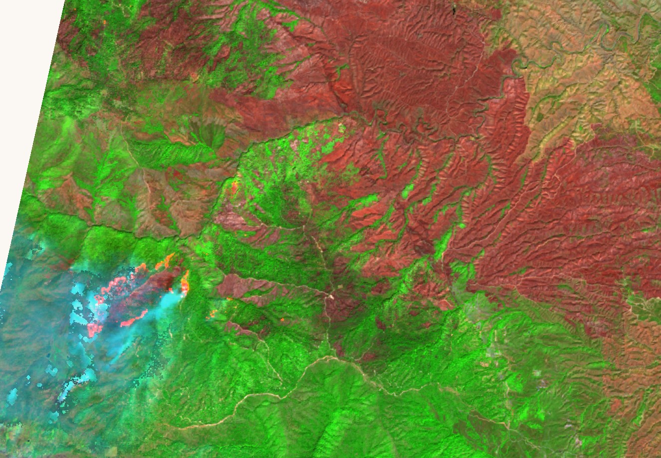
The smoke inversion will lift midday as transport winds out of the S-SW start, which will bring all that smoke down into northern Tehama and western Shasta, hopefully up high and over us, although those winds come out of the bay so it will include all their fires as well. As soon as that smoke lifts over the incident the fire intensity will instantly increase. Winds on the fire will shift 180 after lunch today, from NNW to SSE and grow significantly. Then tonight, diurnals kick in and winds will come back downslope out of NW. That’s tiring for keeping up on the fire lines.

California, Nevada, Illinois and Utah National Guard air assets have been released. They were instrumental the last 3 weeks as every private and agency helicopter around have been working solid on all the CA fires. As other fires have subsided, we have picked up some private Chinooks, Skycranes, and some medium ships as well at Red Bluff Helibase.

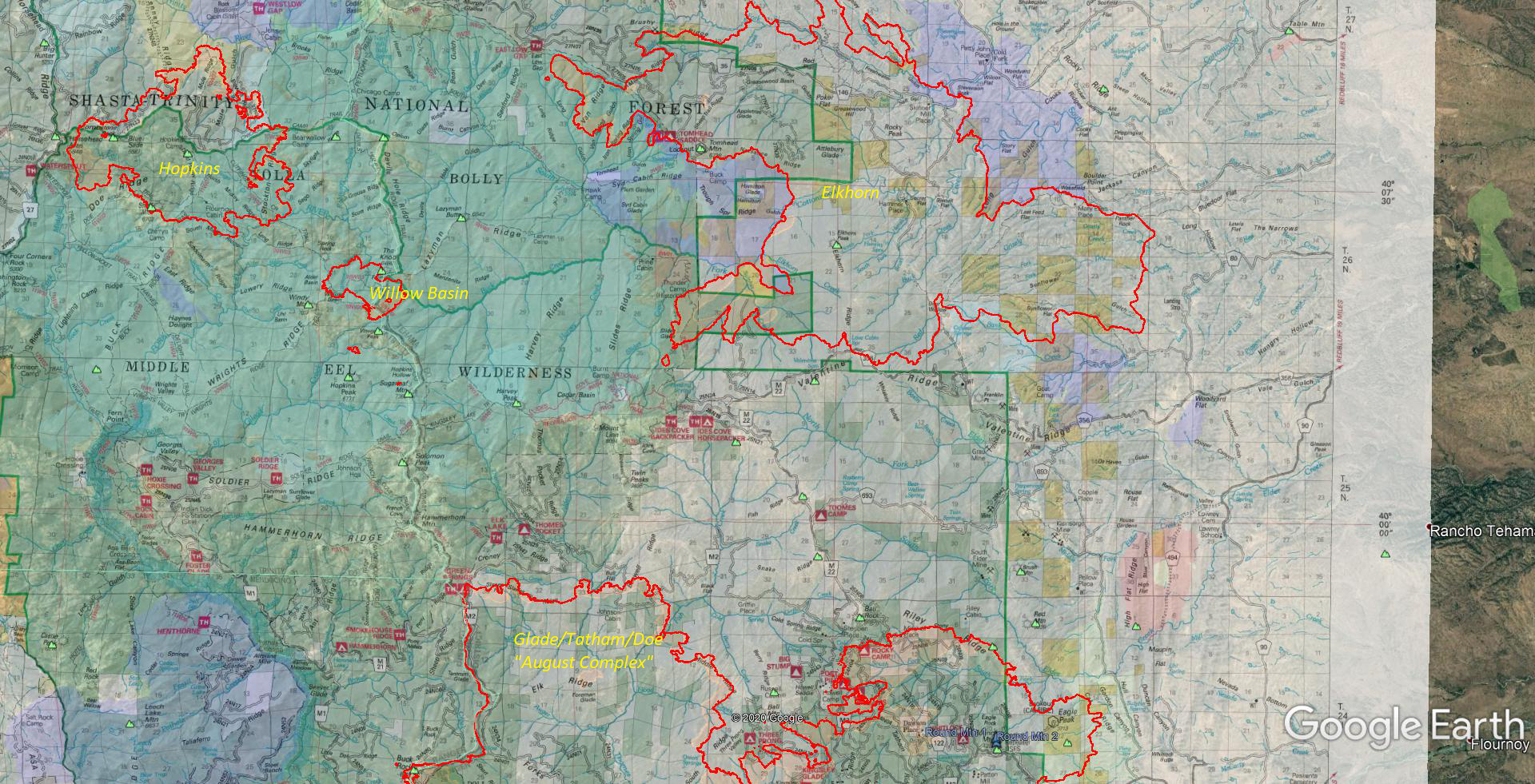
Starting on the north eastern edge of Doe Fire, above Paskenta and Riley Ridge. Fire has still held to Riley Ridge but there are pockets of heat near the line still, up near Ball Rock. They were going to fire it off yesterday but weather conditions weren’t conducive to that. Hopefully they can get that today and make that entire line black. With the upcoming winds, it is critical to hold this line. Any spot over that into South Fork Elder Creek drainage changes the entire game up there. Working west on Doe, fire has been held up so far along Middle Ridge, not sure if they’re going to chase the slops over that dozer line or fall back east to Berry Ridge north of Three Prong. Looking at proposed lines, they are still planning on the large big-picture line from Ball Rock north up the M22 road to Snake Ridge, Raglin Ridge and Fish Ridge/Oven Lid. However their immediate strategy is to try to find a route to dig line closer to the fire edge, to connect the Berry Ridge dozer line over NW to the Elkhorn dozers coming down in the Twin Peaks area. That’s their ideal goal. If any of the northern edge of Doe blows existing lines with these winds, it’s a game changer and likely will burn all the way to Elkhorn along that M22 road and Fish Creek drainage to Ides Cove.

Now with the Elkhorn Fire, east side is good, focusing on the west side. Northern finger still going west inside the Wilderness flanking the ridge and wilderness boundary. A lot of the fire up on top is firing operations to keep the “wild” fire away from the line. They hooked it down Sanford Ridge a bit at East Low Gap. Not sure if they’re planning to hook it here, similar to original plan, but I think this is just a time saver so they don’t have fire nipping their ankles while they build primary containment lines further west past Rat Trap towards Stuart Gap and North Yolla Bolla and the 2017 Buck Fire there. This would eventually become the primary northern line for both Elkhorn and the Hopkins fire burning 5-6 miles west.

Southern finger behind Elkhorn Ridge. They had a successful firing operation late last night securing the line above Valentine Ridge and forcing the fire further west. So far fire has held north of the lines and working west into the wilderness. It’s just north of Ides Cove now. They have completed dozer line right through those trailheads to the west and south to Twin Peaks and the top of Boswell Ridge. Now they’re working with the Doe Fire to figure out how to connect that line over to Berry Ridge and/or lines coming west of M22.

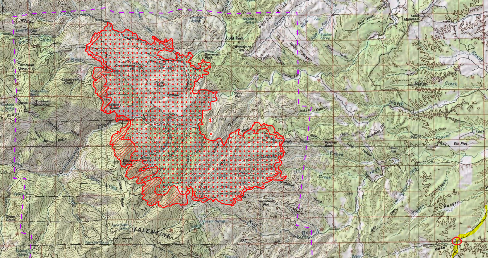
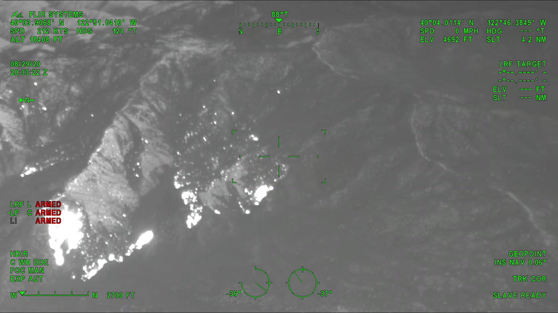
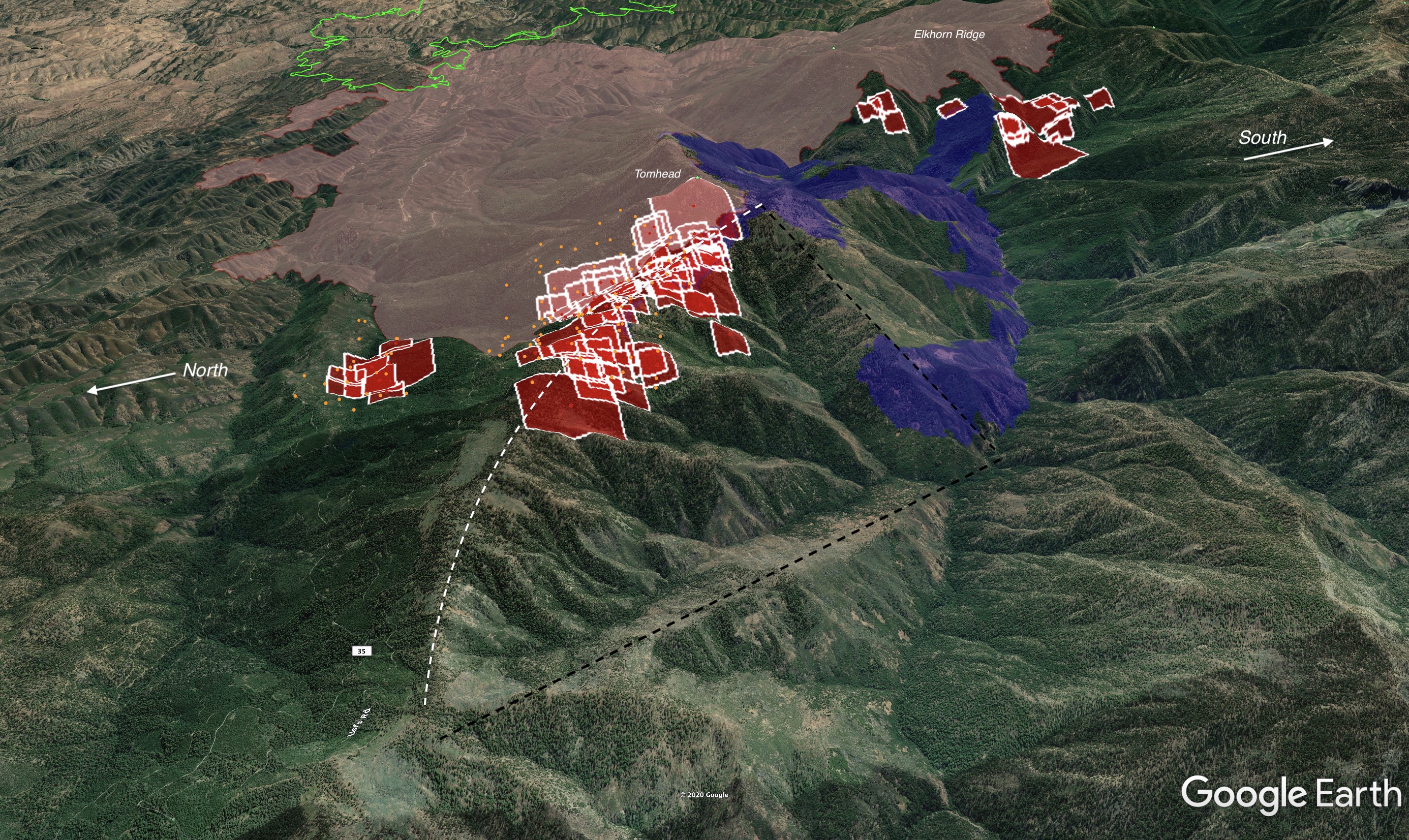
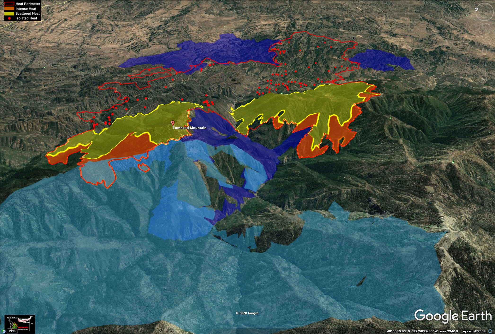
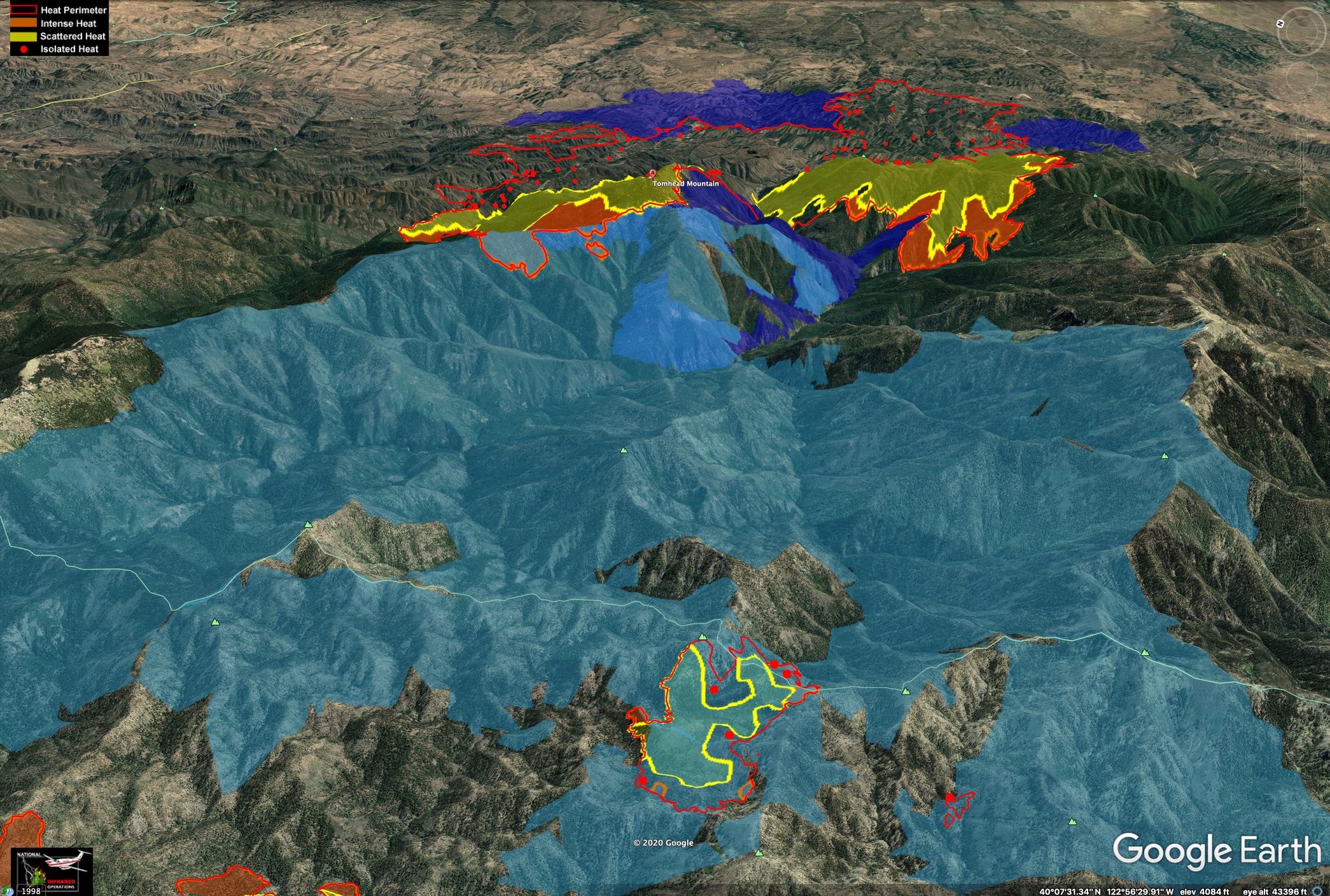
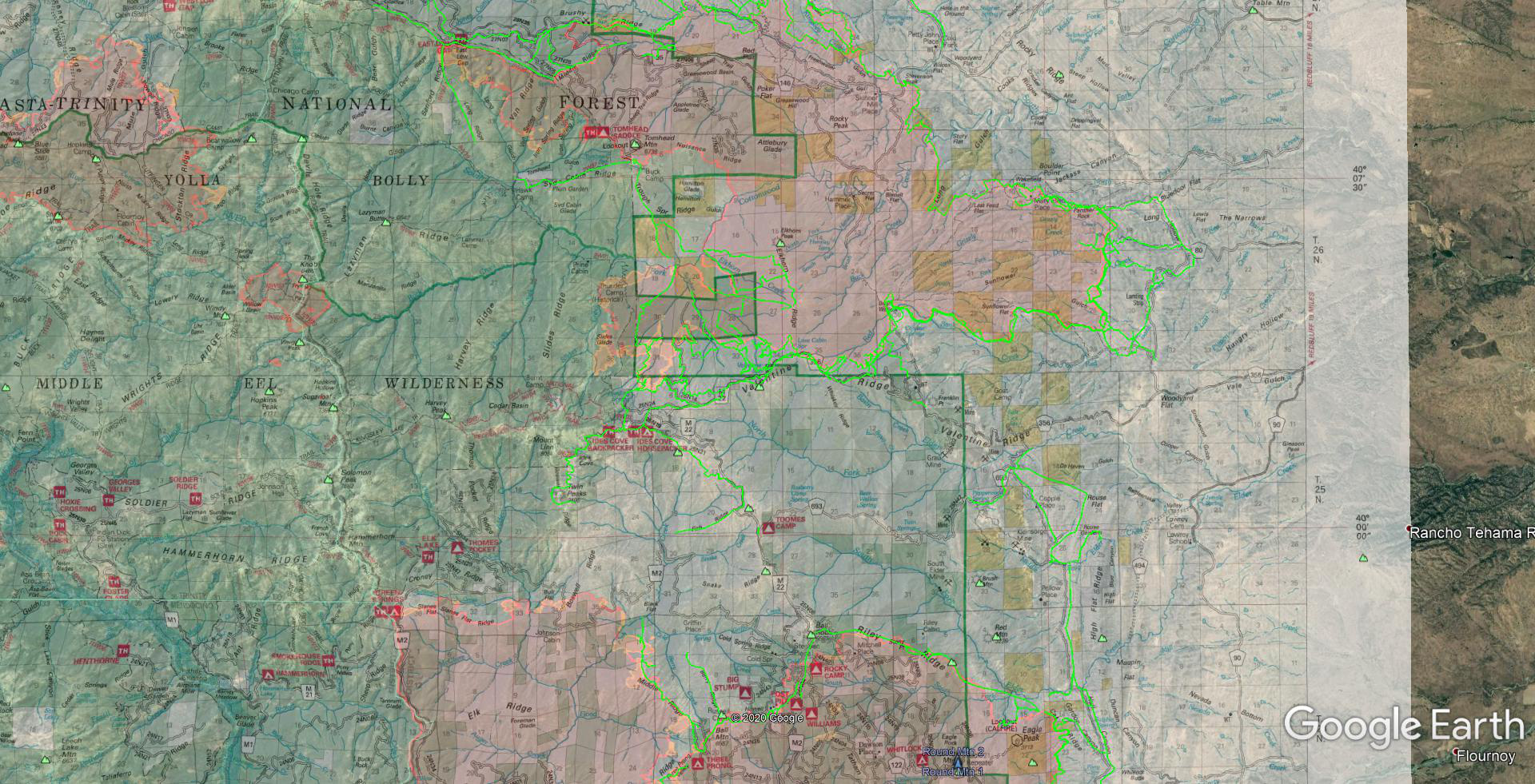
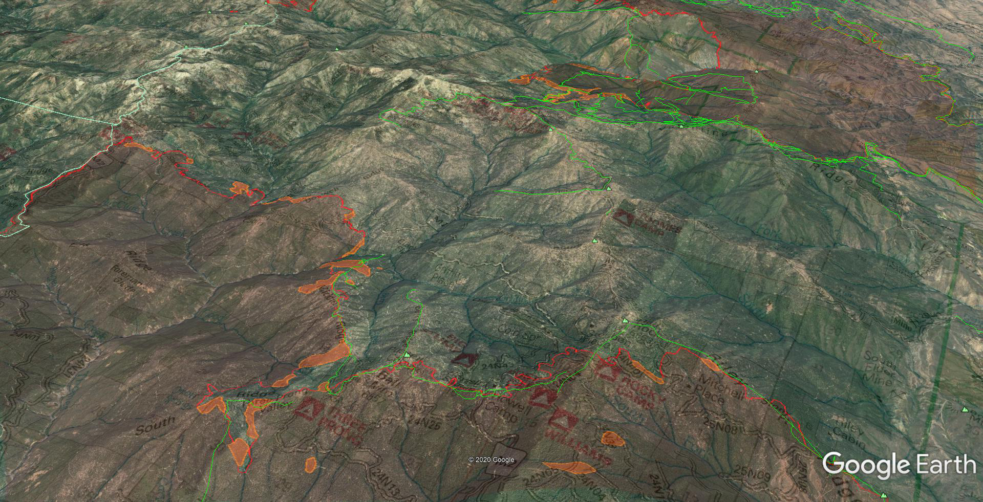
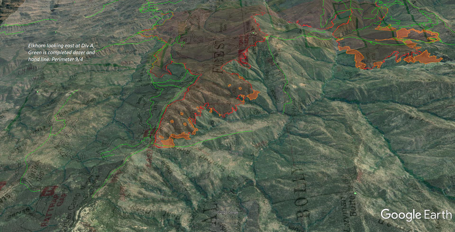
With all the iron and crews pushing line all over this thing, I pulled out the completed dozer and crew line GPS data from the TGU operations as of last night, and threw it into Google Earth, along with last night’s IR mission.

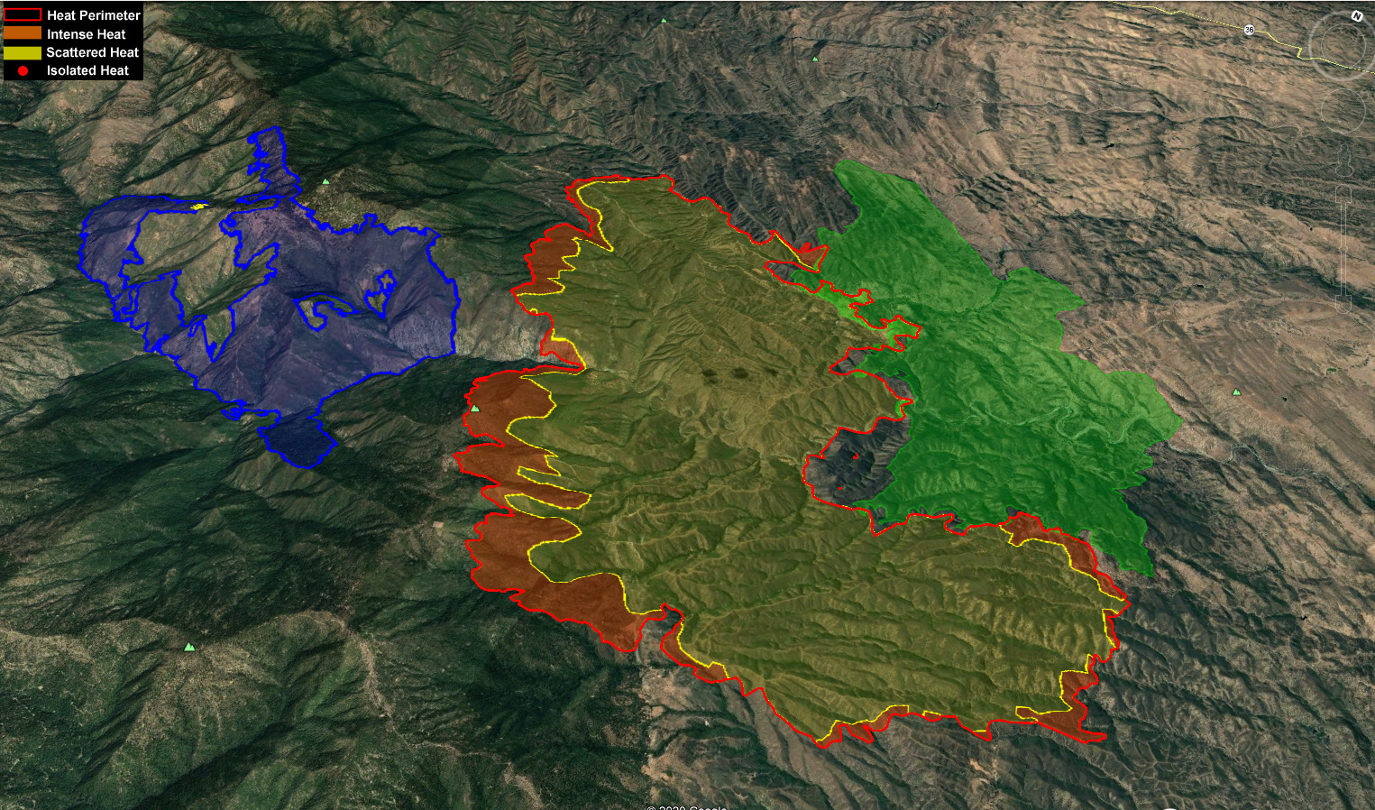
Looking slightly NW towards the Elkhorn from over the Doe, right up the Fish Creek drainage and where the Tehama and Glenn Zones are trying to connect the dots.

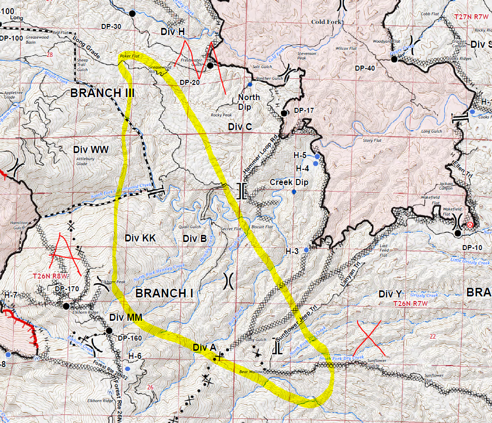
Finally looking east at Elkhorn DIV A, and its westerly spread flanking the wilderness boundary. You can see the handline Feather River IHC had almost completed down Long Ridge before they went big box on Wednesday. While frustrating in the moment, it was apparent the southern finger below them, and the Hopkins to the west, would make this entire area an eventual loss. Great call on that.

Stay safe out there! Hot, dry and shifting winds all weekend.

3 Likes

NorCal Scan. Thanks for your insightful posts. You mentioned the big box…Is the plan now to tie Elkhorn and Hopkins together ?

1 Like

Opinion only here, I think the plan first was to pull troops from the bottom knowing the risk was rising with the southern finger slop and weather conditions, and get back up on top. Then continue to reassess the situation. However that decision weighs heavier on the Forest side vs Calfire and I don’t think they are in Unified Command, more of a “unified understanding” at the moment considering the resource drawdown and scale of the situation.

All that to say, I think Hopkins and Elkhorn will eventually connect. And the western head of Doe.

5 Likes

Thank you, I agree.