NEU sending imm. Need ST also just now
NEU now sending a dozer ST
150 acres with active spotting and transitioning from brush into timber. Believe it’s going from SRA to FRA but a local will need to chime in.
Per AA starting to “pick up…REALLY pick up a head of steam”
250 acres @ 1532
This thing is all SRA, not heading into any FRA without a combination of massive wind change and eight hours. It’s just south of the earlier season Red Bank incident. Like the Red Bank, it’s going to be stubborn with the terrain and logistics due to remoteness from the valley. Lots of VMP burns in the past so lots of old dozer lines to open up and go indirect with a larger box.
Scancal live scanner is in TGU Incident mode now, Air Ground and Command 7 on priority over local nets.
Weather: Not much WX station resolution in this area.
Winds expected to come out of the WNW tonight it looks like, back to N wind tomorrow.
PGE Dream Valley Rd - due south of incident, slightly sheltered in terrain. Lower elevation
PGE Ridge Road - much lower in the valley, east and slightly north of incident. Can give an indication of any eastern flank conditions if this thing gets any lower.
Eagle Peak RAWS - southwest of incident, 1500ft higher elevation but more midslope, not ridgetop.
Rough acreage from Copter 205 puts it at 446.
Looked big from north of Redding this afternoon. ST from Humboldt County headed east at approx 1800, including Kneeland Helitack’s tender.
I was on the Red Bank Fire and thinking about the area this fire is in. There are many contingency dozer lines from the red bank Fire in place, possibly a little further away than ideal, but this is not easy terrain by any means. I got called to go up for station coverage for TGU in the morning.
8 Charlie’s for day shift tomorrow
#RanchFire off Colyer Springs Rd and Raglin Ridge Rd, southwest of Red Bluff in Tehama county is 550 acres and 10% contained.
Air Attack up over fire. Div A first priority, Div M second priority.
Requesting all four type2 and two type1 rotor over the fire, and just requested four type3 and two type1 tankers over the fire. Helibase set up at Red Bluff Airport.
Fire activity is picking up looking at the eagles nest camera.
They’ve lost the SW corner of the fire, Division A. Last numbers I heard was 20 and 50 acre slops RROS with some ranch structures ahead of it. With that loss they upped the aircraft order to four addl T1 rotor and two VLAT.
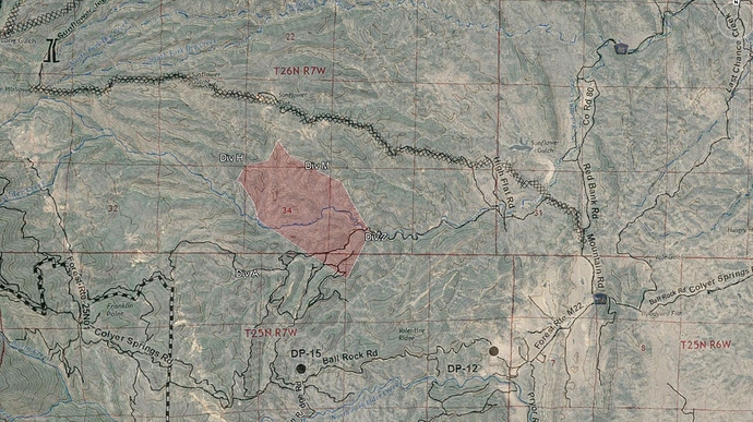
Below is a map I created estimating the fire area based on MODIS/VIIRS, radio traffic, and yesterday’s photo from air attack. I have not heard reference to a Div Z though, that’s more of a place holder. The image overlay is southern end of TGU-Red Bank’s final Ops map, which shows the dozer line they put in along Sunflower Jeep Trail, and some more local references to the roads out there.
750 acres 15%
Two Type 6 ST ordered out of Region IV to report to Incident 0700 tomorrow.
#RanchFire off Colyer Springs Rd and Raglin Ridge Rd, southwest of Red Bluff in Tehama county is 1,308 acres and 15% contained

