Gotcha, I’m sure he wants to paint from A to B and not worry about jurisdiction. The fire certainly doesn’t
Should this get changed to CA-TNF/NEU-Mosquito?
Just sounds like it may have a good mix of FRA and SRA.
Probably more like CA-TNF/NEU/AEU/ENF-Mosquito at the rate things are going.
TF 6849 demobbed from Mountain and in route to Mosquito.
As of this time, the ordering point (OP) is still TNF. Should that change, the incident itself will be updated to address the primary authority. A joint unified command structure does not change who has the control authority. At the end of the day, there will be a single OP and control authority, and who will ultimately have the reporting authority.
It’s seems to be in unified command, since this morning
Understood, I was being somewhat facetious in replying to @fireater17 
Looks like AA 230 will be taking the fire
!
Just received this on my phone
Regional Emergency Alert
The Placer County Sheriff’s Office is issuing a mandatory evacuation order due to a vegetation fire for the following locations. These are the areas what received an evacuation warning earlier in the evening, this has now been changed to a mandatory evacuation. Again, this is a mandatory evacuation for the following areas. Please pay close attention to any evacuation route instructions. Remember to stay calm, take all family members including pets and lock your residence before leaving.
- From Bath Rd/Mosquito Ridge - west to Idlewild Rd
- Streets north of Blackhawk Ln and north of Foresthill Rd (to include Blackhawk, Black Oak, Ebbert Ranch Rd, and all roads off of Blackhawk Ln)
- Finning Mill to Sugar Pine Reservoir
- Elliott Ranch to Finning Mill - all north of Foresthill Rd
© 2022 Everbridge, Inc.
AA said fire is going or has started impacting structures near Michigan Bluff. He wants another lead plane and another LAT. He sounded very serious
Best online scanner for fire traffic ? The ones I’ve found up to now is all law traffic
I’m using this one on Scanner radio. Seems like it’s just Air to ground, mainly to ICP. I did hear AA TX coordinates to a lead plane but I didn’t hear RX.Come to think of it I didn’t here ICP respond
@jimw360 ← thank you for asking - been wondering the same thing. Perhaps something local outside of Broacastify?
This one on the El Dorado side is getting some of the traffic and is sans LE
Looks like T103 (MD-87) out of Fresno made a drop and is heading towards MCC
September 7, 2022 at 12:39 PM
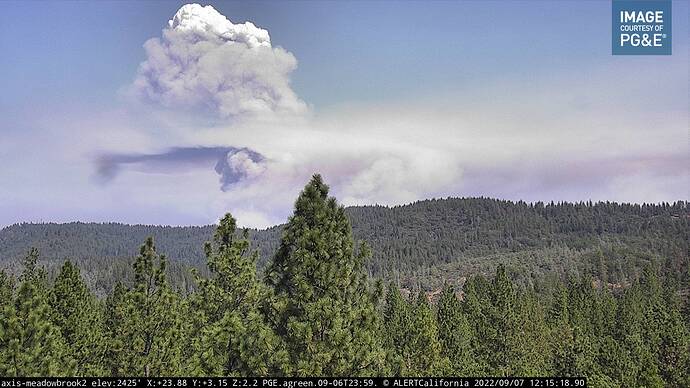
Per FIRIS, OES Intel 12 Mosquito incident FRA burning up into SRA on the TNF. 1,220 acres. Critical rate of spread. Timber and brush. The heel of fires down here, at Oxbow Reservoir, moving up the right flank kind of paralleling the fire. Critical rate of spread as it cranked around the corner there towards the right shoulder. Critical rate of spread with short range spotting. It’s approximately 2 miles from Poorman Creek to the east. And then the head of the fire has some short range spotting and it’s approximately 1.3 miles from Foresthill Road.
And KCRA push alert says ForestHill is under evacuation orders
Who ever has this scanner that @Chainman1 has listed could get AG and air tactics on it as well it would be great.
What site/app? TY!


