State ID: CA
3 letter designator: VNC
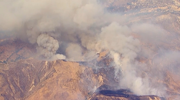
Fire name: Holser
Location: Holser Canyon Road; Piru, CA
Reported acres: 5
Rate of spread: moderate
Report on Conditions: vehicle fire into the brush, running to the ridge with potential for several hundred acres
Structure threat: yes
Resources: LAC, LPF, VNC
Hazards:
Weather: excessive heat warning
Radio channels: VNC CMD-8, VNC TAC-9
Scanner link: https://www.broadcastify.com/webPlayer/2858
Webcam link: http://www.alertwildfire.org/orangecoca/index.html?camera=Axis-SagePeak1&v=81e004f
Agency Website:
1 Like
VNC is starting a 2nd alarm.
50+ acres, IC stating might be closer to 100.
100 acres near shooting range
50 to 100 acres
IC is requesting 2 additional water dropping aircraft and a HELCO
AA340 overhead assuming Holser AA, reports 100 acres in grass with moderate to rapid ROS. Potential for 1,000 acres.
total of 4 tankers on order.
3 additional type 1 engines ordered
2 type 3 strike teams ordered.
1 Like
Live video: https://abc7.com/watch/23340/
Fire is getting into heavier fuels now. Pushing towards Hasley Canyon
1 Like
400 acres
2 more Type 1 helos requested
1 Like
2 Likes
600 to 700 acres in alignment with the canyons and wind to push north and east
IC requesting 3 additional Charlie S/T and 1 additional Alpha S/T for LA County mission. And an additional VNC Battalion Chief for Division Charlie.
1 Like
1135A was first LACO Alpha.
VNC BC14 for DIV C
Cancelled Tanker 944 due to smoke.
2 Likes
UTF 3 hand crews strike teams due to regional drawdown.
3 Likes
1100+ acres w/ 0% containment. BC6 has requested evacuation of 12 homes in Oak Canyon.
3 Likes
Possibility for some resources to be demobed from Lake and sent to Holser. 0700 update from VNC:
Size: Over 2,500 acres
Containment: 20%
Expected Containment: Unknown
Total Personnel on Fire: 400
Current Situation:
Firefighters took advantage of the lower temps and higher relative humidity overnight to perform firing operations to secure the fires edge while taking advantage of natural barriers
Evacuations:
North to Lake Piru, South to Highway 126, excluding the community, East of Val Verde, West to Piru Canyon Road
1 Like
IR flight mapped the fire at approx 3,000 acres
1 Like