CA-YNP-Red & Rodgers & Sept Lightning???

Fire Update: September 12, 2022, 8am

The #RedFire (8,309 acres) and #RodgersFire (2,765 acres) Both are being managed for multiple objectives. Trail closures are associated within these fire areas. For more information, visit:

Red Fire: Red Fire Information - InciWeb the Incident Information System
Rodgers Fire: Rodgers Fire Information - InciWeb the Incident Information System

#YosemiteSeptemberLightning: In the past week, Yosemite Fire and Aviation and partners have responded to multiple new lightning strikes in the park. No closures or evacuations are associated with these incidents at this time. All are/were less than 1/4 acre and have been contained or are being suppressed. No new fires were detected yesterday. More information, visit:

Yosemite September Lightning: Yosemite September Lightning Information - InciWeb the Incident Information System

#ChiquitoFire: Chiquito Pass/Chain Lakes area, near the park’s southeast boundary
#TurnerFire: east of Alder Falls, along Turner Ridge, northeast of the Wawona Road above Alder Creek
#EmpireFire: near Empire Meadows, Badger Pass area
#WolfFire: Along Tioga Road, east of White Wolf
#ObeliskFire: East of Starr King Meadow/ west of Lake Obelisk/Mt. Clark
#RanchFire: Northeast of Hetch Hetchy Reservoir
#AlderFire: North of Alder Creek, northwest of Wawona

Current Air Quality
View current air quality conditions throughout Yosemite National Park and the region at https://fire.airnow.gov/

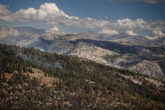
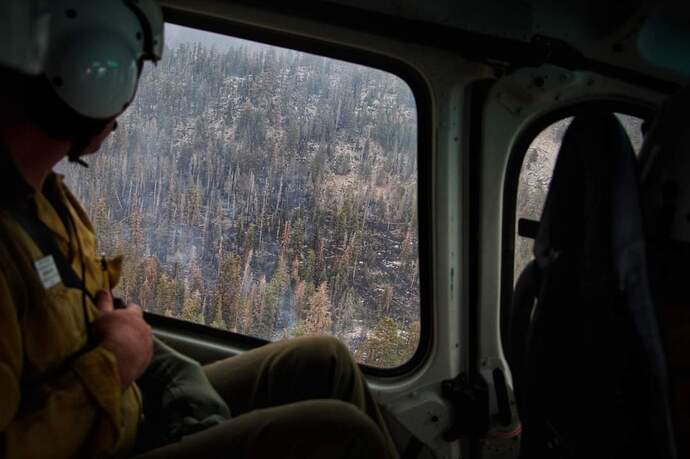
Photo from aerial reconnaissance of the #RedFire on September 11, 2022 shows little fire activity after precipitation moved through the park. Photo by Kaleena Lynde/USFS
6 Likes

Possible new holdover N of Hetch Hetchy

Fire Update: September 13, 2022, 8am

The #RedFire (8,383 acres) and #RodgersFire (2,774 acres) are being managed for multiple objectives. With recent precipitation, both are showing minimal growth. Trail closures are associated within these fires. For more information, visit:

Red Fire: Red Fire Information - InciWeb the Incident Information System
Rodgers Fire: Rodgers Fire Information - InciWeb the Incident Information System

#YosemiteSeptemberLightning: Since September 5, Yosemite Fire and Aviation and partners have responded to multiple new lightning strikes in the park. No closures or evacuations are associated with these incidents at this time. All are/were less than 1/4 acre and have been contained or are being suppressed. Today is expected to be the last day of thunderstorm activity as a drier weather pattern enters the area. Temperatures are expected to remain near seasonal normals. One possible new holdover fire was detected on infrared maps yesterday north of Hetch Hetchy; crews will verify and assess that today. More information, visit:

Yosemite September Lightning: Yosemite September Lightning Information - InciWeb the Incident Information System

#ChiquitoFire: Chiquito Pass/Chain Lakes area, near the park’s southeast boundary
#TurnerFire: east of Alder Falls, along Turner Ridge, northeast of the Wawona Road above Alder Creek
#EmpireFire: near Empire Meadows, Badger Pass area
#WolfFire: Along Tioga Road, east of White Wolf
#ObeliskFire: East of Starr King Meadow/ west of Lake Obelisk/Mt. Clark
#RanchFire: Northeast of Hetch Hetchy Reservoir
#AlderFire: North of Alder Creek, northwest of Wawona

Smoke
Air quality in the forecast area has greatly improved over the last day. Today, mostly Good AQI in the foothill communities is likely, with Moderate AQI for sites within the park. Smoke may be increasing as fuels dry out and the fires become more active later in the week.

Current Air Quality
View current air quality conditions throughout Yosemite National Park and the region at https://fire.airnow.gov/

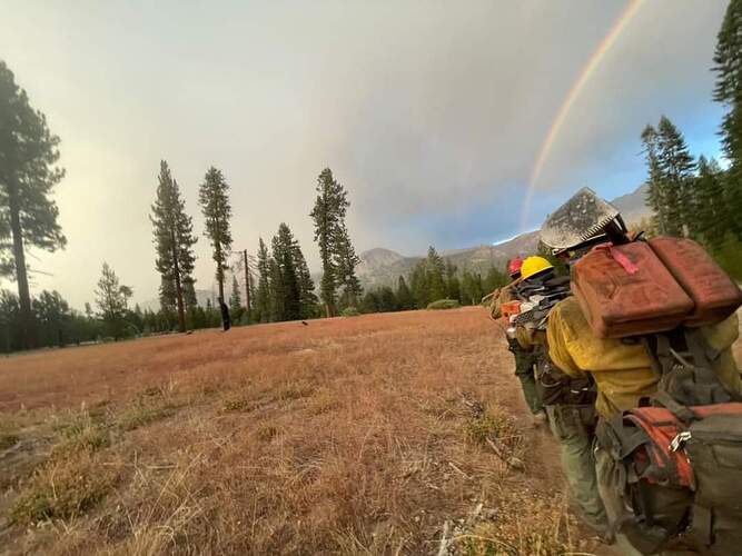
Image of rainbow over firefighters hiking across a meadow by Claire Jimmy, Springville IHC

5 Likes

AA15 flew the Red fire this morning. Didn’t monitor the YNP fire net for his intel.

Also few recon for lighting holdovers on the SQF and SNF before returning to Fresno.

4 Likes

Fire Update: September 14, 2022, 8am

The #RedFire (8,383 acres) and #RodgersFire (2,774 acres) are being managed for multiple objectives. With recent precipitation, both continue to show minimal heat. However, with warmer and drier could result in slightly more activity today. Trail closures are associated within these fires. For more information, visit:

Red Fire: Red Fire Information - InciWeb the Incident Information System
Rodgers Fire: Rodgers Fire Information - InciWeb the Incident Information System

#YosemiteSeptemberLightning: In the past week, Yosemite Fire and Aviation and partners have responded to multiple new lightning strikes in the park. No closures or evacuations are associated with these incidents at this time. All are/were less than 1/4 acre and have been contained or are being suppressed, unless otherwise noted. Weather today is expected to be drier, which could cause a slight increase in fire activity, and crews are on the lookout for any holdover lightning strikes. Winds are predicted to be light and seasonal. Vegetation remains extremely dry, despite the wetter weather of the past few days.
Yosemite September Lightning: Yosemite September Lightning Information - InciWeb the Incident Information System
#ChiquitoFire: Chiquito Pass/Chain Lakes area, near the park’s southeast boundary
#TurnerFire: east of Alder Falls, along Turner Ridge, northeast of the Wawona Road above Alder Creek
#EmpireFire: near Empire Meadows, Badger Pass area
#WolfFire: Along Tioga Road, east of White Wolf
#ObeliskFire: East of Starr King Meadow/ west of Lake Obelisk/Mt. Clark
#RanchFire: Northeast of Hetch Hetchy Reservoir
#AlderFire: North of Alder Creek, northwest of Wawona

Smoke
Good air quality (AQI) is likely throughout the forecast area today with the exception of Yosemite Valley, which is likely to be unhealthy for sensitive groups (USG). As fire activity increases, smoke impacts may increase and some haze may be visible in the drainages overnight into the morning.

Current Air Quality
View current air quality conditions throughout Yosemite National Park and the region at https://fire.airnow.gov/

1 Like

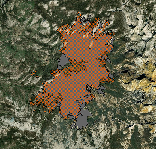
Thought this was interesting—the Red Fire (orange hatches) has reburned essentially in the 2001 Hoover Fire’s (gray) exact footprint, thanks to the natural barriers and probably the down fuels. Both were lightning starts.

13 Likes

Fire Update: September 15, 2022, 8am

The #RedFire (8,383 acres) and #RodgersFire (2,774 acres) are being managed for multiple objectives. Fire activity has slowed considerably in the last several days, although vegetation (especially in lower elevations) remains extremely dry.

Red Fire: Red Fire Information - InciWeb the Incident Information System
Rodgers Fire: Rodgers Fire Information - InciWeb the Incident Information System

#YosemiteSeptemberLightning: Since September 5, Yosemite Fire and Aviation and partners have responded to multiple new lightning strikes in the park. No closures or evacuations are associated with these incidents at this time. All are/were less than 1/4 acre and have been contained or are being suppressed, unless otherwise noted.
Yosemite September Lightning: Yosemite September Lightning Information - InciWeb the Incident Information System
#ChiquitoFire: Chiquito Pass/Chain Lakes area, near the park’s southeast boundary—in patrol status
#TurnerFire: east of Alder Falls, along Turner Ridge, northeast of the Wawona Road above Alder Creek—in patrol status
#EmpireFire: near Empire Meadows, Badger Pass area — crew in on-scene, working on containment.
#WolfFire: Along Tioga Road, east of White Wolf —out
#ObeliskFire: East of Starr King Meadow/ west of Lake Obelisk/Mt. Clark—in patrol status
#RanchFire: Northeast of Hetch Hetchy Reservoir —out
#AlderFire: North of Alder Creek, northwest of Wawona—in patrol status

Current Air Quality
View current air quality conditions throughout Yosemite National Park and the region at https://fire.airnow.gov/

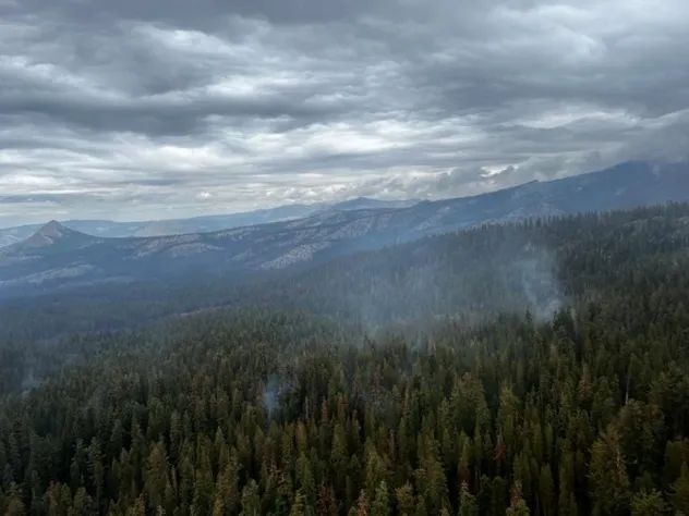
Photo: The #RodgersFire continues to smolder and creep, consuming vegetation like brush and dead and downed logs. Fire effects like this help prevent future high-intensity wildfires and maintain the health of this fire-adapted ecosystem. Photo by Kaleena Lynde/USFS

4 Likes

Fire Update: September 16, 2022, 8am
*Information on these fires will be updated only as conditions change.

Precipitation is predicted to enter the fire area over the weekend, and fire activity is expected to decrease considerably. Fire behavior will be dependent on weather, with slightly more activity visible when conditions are clear and dry.

The #RedFire (8,364 acres) and #RodgersFire (2,785 acres) are being managed for multiple objectives.

Red Fire: Red Fire Information - InciWeb the Incident Information System
Rodgers Fire: Rodgers Fire Information - InciWeb the Incident Information System

#YosemiteSeptemberLightning: Since September 5, Yosemite Fire and Aviation and partners have responded to multiple new lightning strikes in the park. No closures or evacuations are associated with these incidents at this time. All are/were less than 1/4 acre and have been contained or are being suppressed, unless otherwise noted.

Yosemite September Lightning: Yosemite September Lightning Information - InciWeb the Incident Information System
#ChiquitoFire: Chiquito Pass/Chain Lakes area, near the park’s southeast boundary—in patrol status
#TurnerFire: east of Alder Falls, along Turner Ridge, northeast of the Wawona Road above Alder Creek—in patrol status
#EmpireFire: near Empire Meadows, Badger Pass area — crew in on-scene, working on containment.
#WolfFire: Along Tioga Road, east of White Wolf —out
#ObeliskFire: East of Starr King Meadow/ west of Lake Obelisk/Mt. Clark—in patrol status
#RanchFire: Northeast of Hetch Hetchy Reservoir —out
#AlderFire: North of Alder Creek, northwest of Wawona—in patrol status

Current Air Quality
View current air quality conditions throughout Yosemite National Park and the region at https://fire.airnow.gov/

How do we supply our firefighters with necessities and equipment when we have multiple remote fires? Along with trail crews, we rely heavily on helicopters! During these incidents, helicopters have transported over 30,000 lbs. in cargo loads. WOW! Video by Kaleena Lynde/USFS

https://fb.watch/fBGNfYpGBQ/

3 Likes

We are happy to report we have received a bit of precipitation in the park the last couple days along with some lower temperatures! Due to completion of work, and lower fire activity, CA Interagency Incident Management Team 10 demobilized on Saturday, September 17 and the fires transitioned and downsized to a local type 4 organization.

The #Rodgersfire is in patrol status at 2,790 acres.
The #Redfire remains at 8,364 acres with 51 firefighters assigned.

NPS Photo R.Mitchell / sky blanketed in clouds and light smoke rising from the Red fire.FB_IMG_1663634839191

8 Likes

Red fire is 8410 acres now.
Rodgers is 2815 acres.

1 Like

Yeah I tried to post this the other day but I couldn’t cause the “3” rule

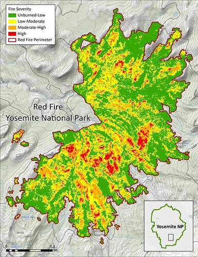
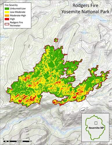
These satellite imagery maps from September 23 show the majority of the #Redfire (8,410 acres) and #Rodgersfire (2,825 acres) with low to moderate fire severity effects (green and yellow), with small patches of moderate-high (orange) to high-severity (red) effects. Fire severity refers to the ecosystem impacts of a fire such as tree mortality or loss in biodiversity.

Severity mapping from satellite imagery detects changes in vegetation cover from before to after a fire, low-severity means there has been little change in the vegetation cover, while high-severity means much of the vegetation cover in that area has been temporarily lost. The areas showing high-severity effects in these maps are dominated by shrubfields, which naturally burn at higher intensities when conditions are very dry. These extreme drought conditions are increasingly common in Yosemite and the surrounding Sierra Nevada mountains with climate change, and above average temperatures exacerbate dry conditions.

The patchwork of fire severities promotes heterogeneity, increasing multiple kinds of wildlife habitat and associated biodiversity, and reducing future risk of catastrophic wildfire.

We are fortunate to have a fire effects monitoring program and crew who study and conduct research to learn about ecological impacts in the forest. You can learn more here: Fire Ecology and Monitoring - Yosemite National Park (U.S. National Park Service)
#satelliteimagery #fireseverity #healthyforest

4 Likes

If you want to explore the fire severity in Google Earth Pro, here are some overlays of recent IR Sentinel imagery. If you turn the IR imagery on and off, you can really see what they’re talking about with high severity patches being mainly in the shrubs.

7 Likes

The overlays on Google Earth really show that areas with no overstory due to past fire but had tons bear clover and shrubs are predominantly the high severity burn areas in the red fire.

6 Likes