It means it will be the worst fire season ever, of course
7 Likes
3 Likes
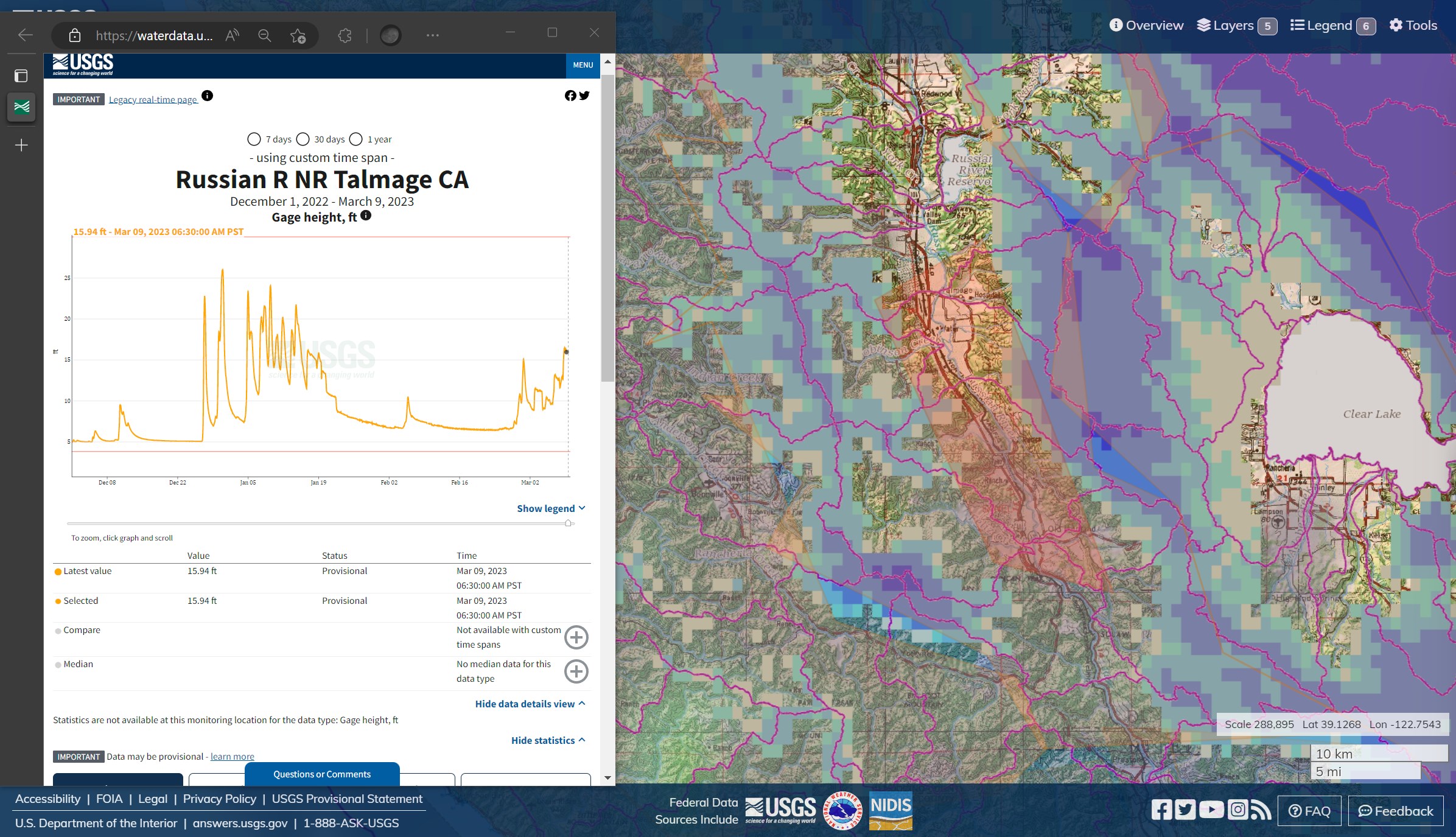
Mendocino County. Russian River south of Lake Mendocino and Ukiah. Flood Warning (active flooding). The gage height is lower by a fair bit than the peak they saw around New Years. On the face of it, it does appear that the bulk of the water is coming from Robinson, Howell, Morrison, Mill Creeks, down the sides of the Russian River basin from the snowpack areas. Seems like pretty strong evidence for rain-on-snow effects. CCC Ukiah in the water, earnin’ them Flood Fighter rockers. 
[I wore a Firefighter rocker in '91-92, at Placer, Greenville and the Academy, Type 2 swamper and HEQ, I don’t know that specialty existed, we were mostly mountain crew back then. I deployed to a fire in Shasta-Trinity. I was assigned to a lot of Academy, then, but all the local crews went to the Oakland Hills fire. There are a lot of schools, now. A crewmate from the Construction Unit was from Mendocino. Even though, 6 months in the 9th Ward after Katrina taught me to sleep better at night with Flood Fighters on watch. I think there is a lot more to be said for the Flood Fighter rocker, but this isn’t really the forum for that. Just ask me if the CCC needs a central Academy!]
5 Likes
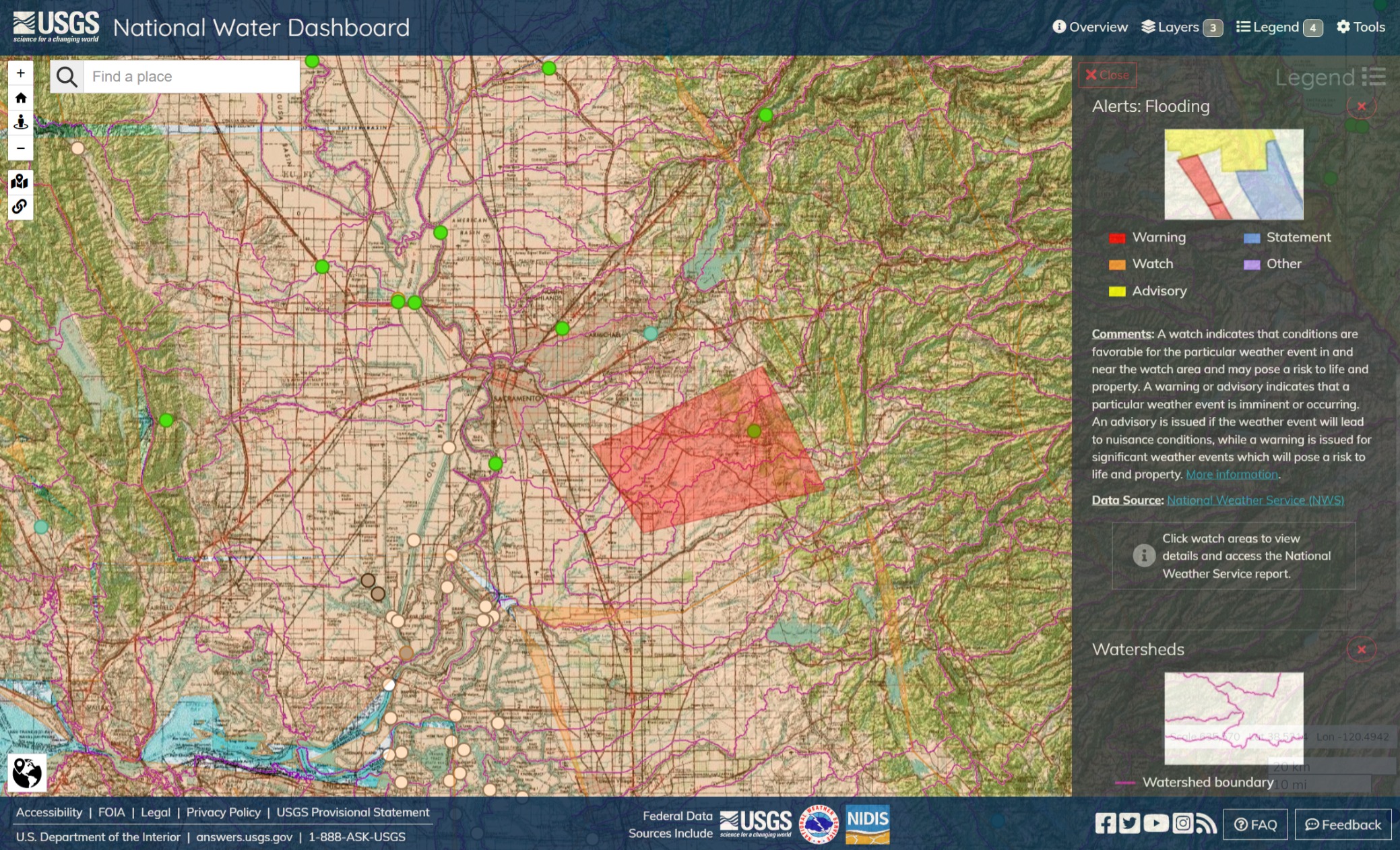
Maybe, just to illustrate the point that the gages don’t tell the whole story. All four gages triangulated on active flooding are in the green. A bad levee breach or underground issue can flood even with moderate streamflow. These readings are less than an hour old.
3 Likes
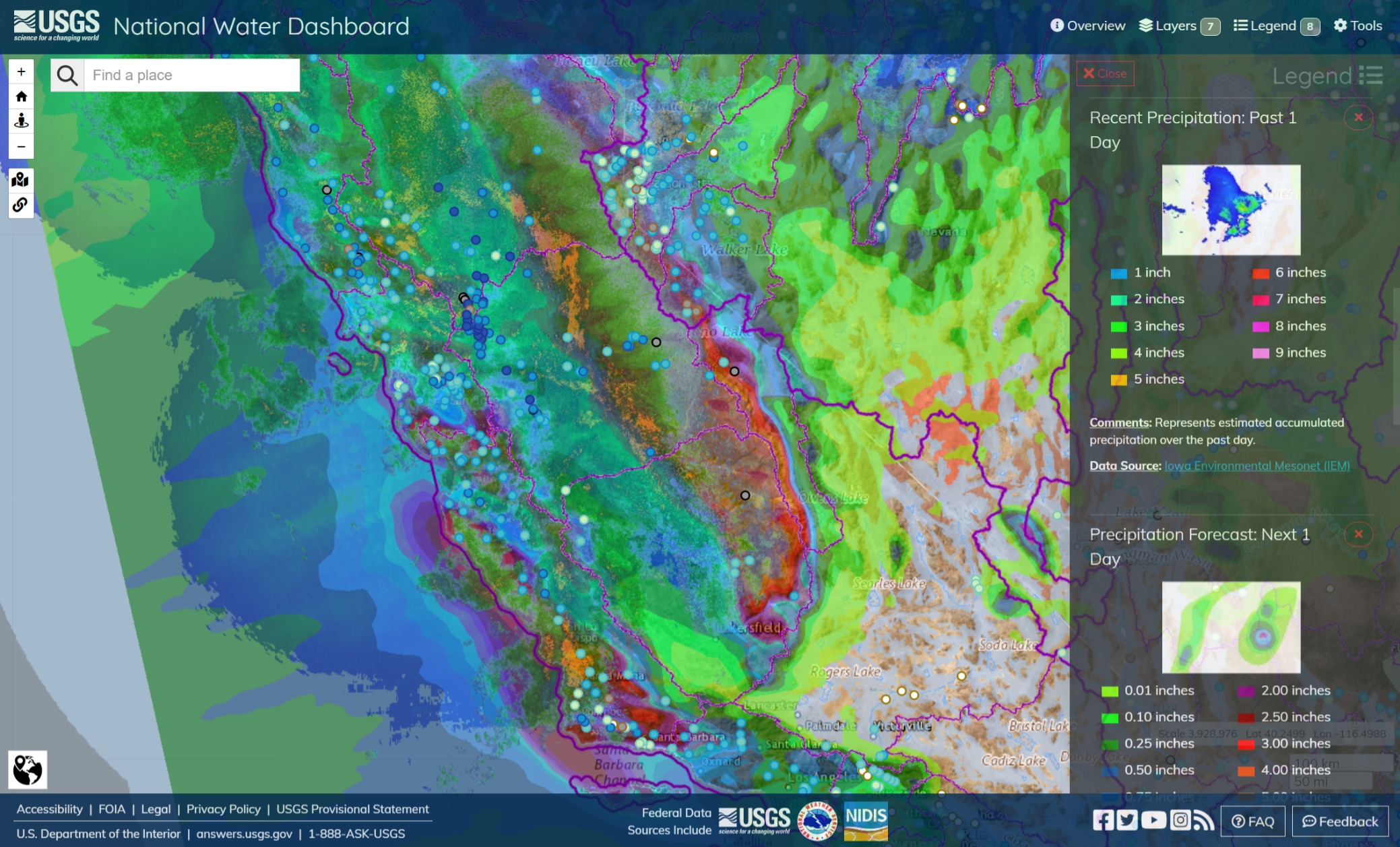
Enhanced color. Precipitation and radar; past 24hrs, current radar, next 24hrs forecast. Relative streamflow to historical mean, darker color is heavier flow.
3 Likes
3 Likes
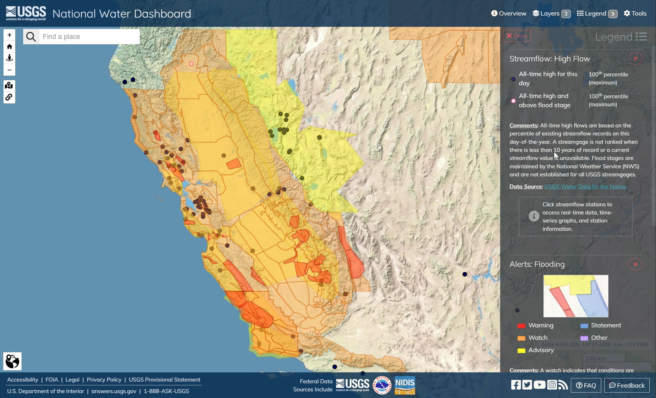
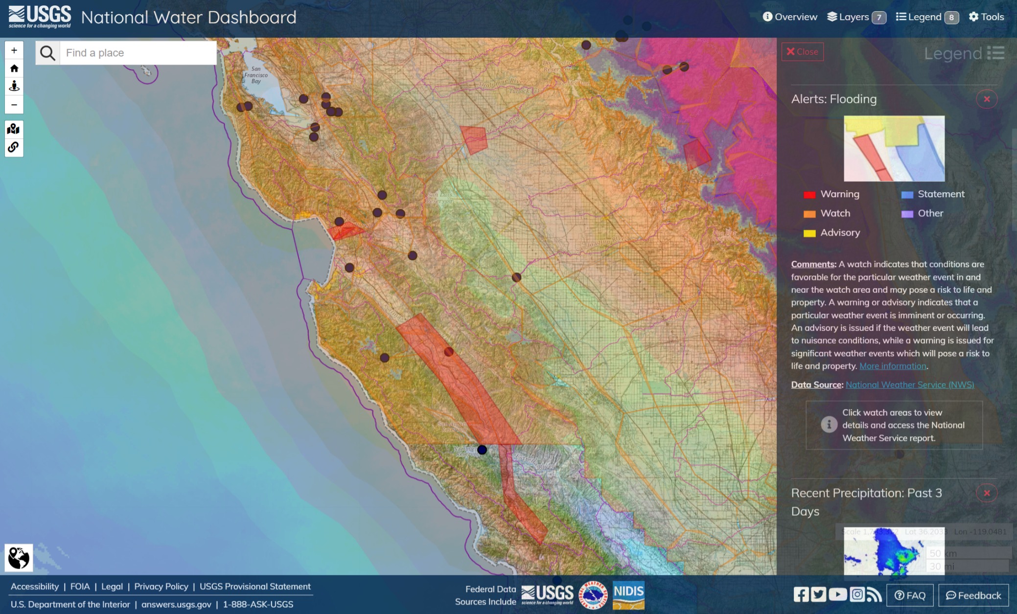
As of 0840 Mar 10, Watches and Warnings across the state. Several gages in Minor and Moderate Flood (red circles). Notable flash flooding in the Santa Cruz, Los Padres, the Sierra - Madera foothills and Owens Valley. All-time calendar day high streamflows in and around Lake Tahoe, Carson Valley and Walker River.
3 Likes
Cal OES Prepositions Additional Flood Fighting Resources as Storms Impact State | Cal OES News
The prepositioned fire resources include:
Santa Barbara County:
- 4 Local Government Engines Type 3
- 1 Local Government Loader
- 1 Local Government Excavator
- 1 Local Government Road Grader
- 1 Local Government Dispatcher
- 1 Local Government Hand Crew Type 2IA
Contra Costa County:
- 3 Local Government Engines Type 1
- 1 Local Government Hand Crew Type 2IA
- 5 Local Government IMT Members
Mendocino County:
- 5 Local Government Engines Type 3
- 2 Local Government Dozers Type 2
Marin County:
- 2 Local Government Dispatchers
- 1 Local Government Loader
- 2 Local Government Engines Type 3
- 2 Local Government US&R Companies
Monterey County:
- 6 Local Government Engines Type 3
- 1 Local Government Engine Type 1
- 8 Local Government IMT Members
- 1 Local Government Swiftwater Rescue Team
Glenn County:
- 5 Local Government Engines Type 3
- 2 Local Government IMT Members
Butte County:
- 1 Local Government Swiftwater Rescue Team
- 1 Local Government Dispatcher
Alpine County:
- 1 Local Government Engine Type 1
- 1 Local Government IMT Member
Calaveras County:
- 6 Local Government Engines Type 3
- 3 Local Government IMT Members
El Dorado County:
- 3 Local Government Engines Type 3
- 1 OES Engines Type 3
- 1 Local Government IMT Member
- 1 Local Government Swiftwater Rescue Team
Placer County:
- 3 Local Government Engines Type 3
- 2 Local Government Swift Water Rescue Teams
Nevada County:
- 1 Local Government Engine Type 3
- 1 Local Government Engine Type 6
- 2 OES Engines Type 6
- 1 Local Government IMT Member
- 1 Local Government Swift Water Rescue Team
Tuolumne County:
- 5 Local Government Engines Type 3
- 2 Local Government IMT Members
Tahoe Basin:
- 5 Local Government Engines Type 3
- 1 Local Government IMT Member
Fresno County:
- 1 Local Government Dozer Type 2 with Dozer Tender
- 2 Local Government Engines Type 3
- 1 Local Government Dispatcher
- 8 Local Government IMT Members
- 2 Local Government Swift Water Rescue Teams
Kern County:
- 1 Local Government Dozer Type 2
- 2 Local Government Road Graders
- 1 Local Government Helicopter with Hoist
- 3 Local Government Hand Crews Type 2
- 7 Local Government IMT Members
- 1 Local Government US&R Company
Merced County:
- 1 Local Government Swift Water Rescue Team
Tulare County:
- 1 Local Government Swiftwater Rescue Team
- 1 Local Government Dispatcher
- 19 Local Government IMT members
San Bernardino County:
- 10 OES Engines Type 3
- 1 Local Government IMT Member
Inyo County:
- 5 Local Government Engines Type 3
- 1 Local Government Engine Type 1
- 1 Local Government Engine Type 6
- 1 Local Government US&R Type 1
- 2 Local Government IMT Members
Prepositioned Swift Water resources include:
Riverside County:
- OES: Riverside Fire Department Swift Water Rescue Team 6
Inyo County:
- OES: San Diego City Fire Department Swift Water Rescue Team 8
Sacramento County:
- OES: Sacramento Fire Department Swift Water Rescue Team 7
San Mateo County
- OES: Menlo Park Fire Department Swift Water Rescue Team 3
Monterey County:
- OES: Oakland Fire Department Swift Water Rescue Team 4
Merced County
- OES: Orange County Fire Department Swift Water Rescue Team 5
Los Angeles County:
- OES: Los Angeles City Fire Department Swift Water Rescue Team 1
- OES: Los Angeles County Fire Department Swift Water Rescue Team 2
Mendocino County:
- OES: Marin County Fire Department Swift Water Rescue Team 11
3 Likes
Kernville got hit very hard. The river was flowing at 945 cfs at midnight but is up to 44,000.
7 Likes
The ponderosa lodge is no more.
https://www.facebook.com/groups/1004571346293729/permalink/5952530464831101/
3 Likes
1 Like
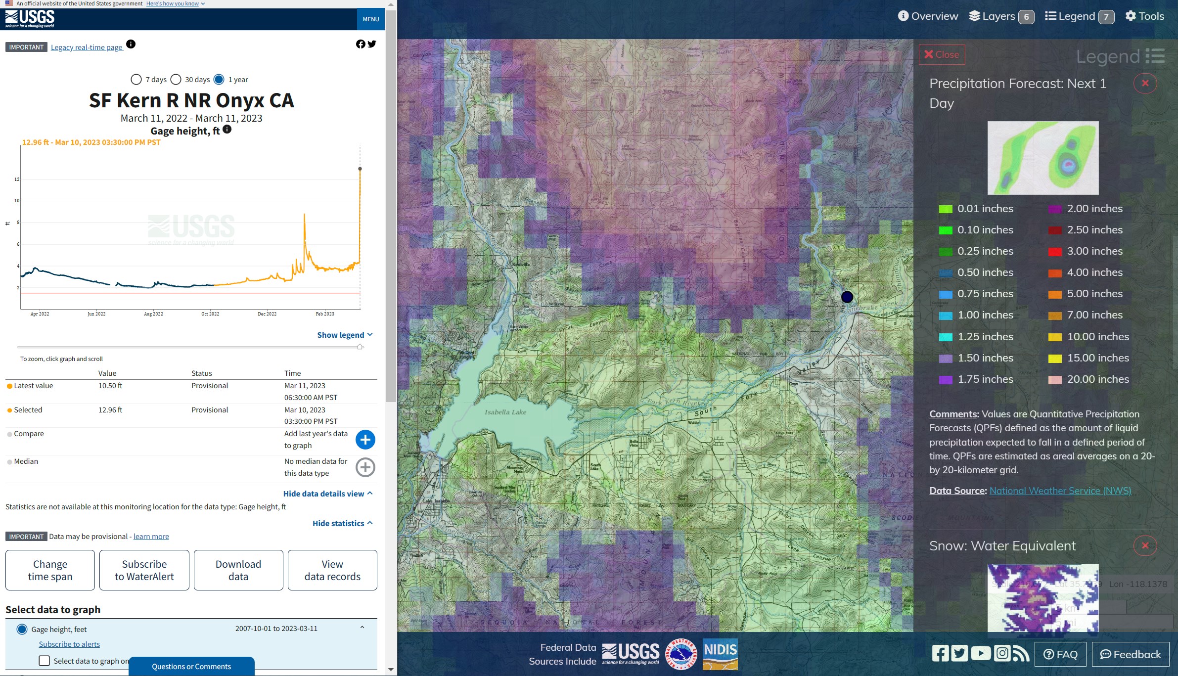
South Fork of the Kern River, east of Isabella Lake and Kernville. Gage height is roughly 20 percent higher than it was during the Dec-Jan storms (“Piper”). Not only is the Kern River flooding north to south of the lake, but the south fork is also pushing really hard on Isabella. Pretty much everything north and west of the lake has flooded. Looks like the skies will clear a little bit through Monday, and then another inch or so of rain. Highways 178 and 155 are open as far as Wofford Heights on the Kern, with washout at Tillie Creek, and Weldon on the south fork side of the lake (via QuickMap).
2 Likes
I sorta feel like the Salinas River has been one of the dark horses of the winter, so far. It’s got flooding from Monterey to Paso Robles. The Los Padres Mountains have a fraction of the snow of the Sierras, but the effect of the chaparrals on the Salinas appears to be large in proportion along the range. I suspect rain-on-snow may account for a bit of this. The pack on the northern ranges of the LP wasn’t so deep.
1 Like
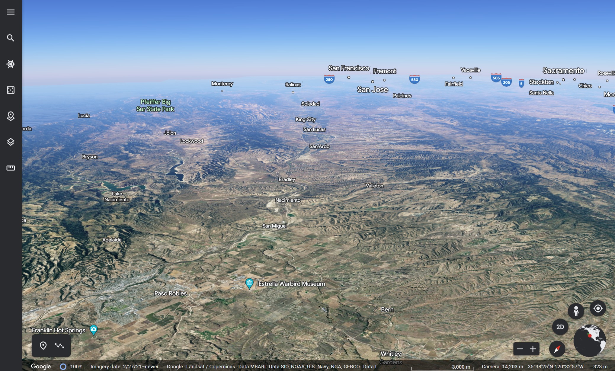
Maybe, this image captures something of the issues. Looking north by northwest from Paso Robles Air Attack Base. From Lake Nacimiento to Arroyo Seco FS, Hunter-Ligget and Carmel Valley on the left side of the Salinas, looking north, and Pinnacles National Monument and Watsonville on the right side, it aaall goes into the Salinas River.
Turn a 360 over Paso Robles and Santa Margarita Valley rises up to ‘the grade’, where Highway 101 goes up, over and down to the coast through San Luis Obispo. This belongs to the Salinas River, too, even unto up beyond Santa Margarita Lake and Pozo Creek. 175 miles; from Transverse headwaters to the Pacific Ocean in Monterey Bay.
Paso Robles is getting a lot of stormwater from the south of this image, as well.
3 Likes
I just talked to a friend in Ponderosa. They are isolated and feeling abandoned by Tulare county
1 Like
The Federal Emergency dec will help. I’m seeing more and more CalGuard activations, too. They bring a lot of capability. Like wildfire, sometimes the problem is not enough operators. Seeing railcar loads of dozers sitting on the side of a road is frustrating.
3 Likes
Note the snorkels on these Guard transports. They can ford as long as the engine, not to mention the occupants, can breathe and continue to provide power when its in a channel. Driving these and other swimmers is not easy.
2 Likes
You have to know the condition of the road you can’t see under muddy water. Where are the edges of the road? So do you put a guy out in the water with a pole? Or is there a fish finder like device so you can see the bottom?
Ideas?
2 Likes
The bottom you have right now might not be the bottom your going to have presently.
3 Likes
Likely going to lose a part of your bottom if you sink your vehicle in a hole.
1 Like