They pretty much have been again, I won’t go further with that. I feel bad for the unit that did show up to the fire apparently and couldn’t take action because nothing else could get up there.
2 Likes
My question is why would you put a flat roof in Pollock Pines?
4 Likes
2 Likes
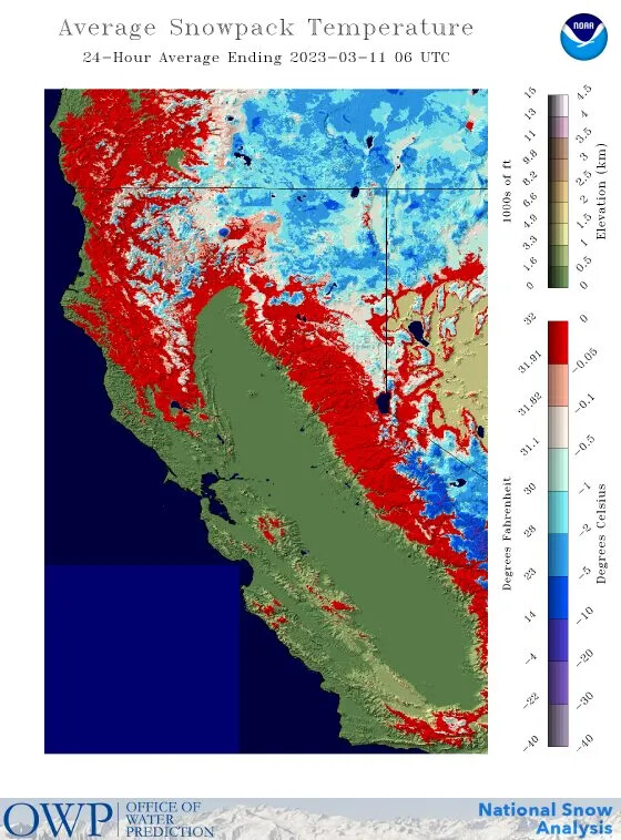

Snowpack in the Sierra, Flash Flood above Lake McClure. The Merced and Tuolumne part ways there, south of Don Pedro Reservoir, perhaps illustrated by the watershed funnels.
Merced meets San Joaquin in the complex at the westerly flood zone.
3 Likes
Was just up there today looking. These houses survived! The park not so much. And for those wondering Camp 9 sadly did survive as well.
5 Likes
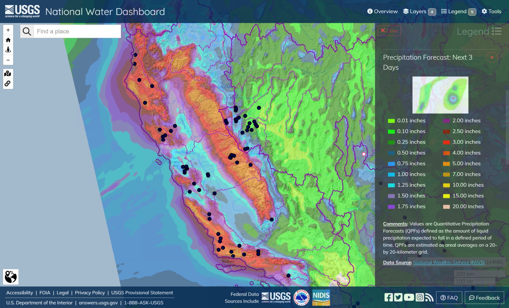
Ain’t no rest for the wicked. The lower Salinas is in Moderate Flood Stage. The Alameda River has retreated. Enhanced color precip inbound over the next 72 hours.
(Santa Rosa at Willowside passed a +7ft wave or it was an artifact. Santa Rosa not in Flood Stage.)
2 Likes
CNRFC - California Nevada River Forecast Center (noaa.gov)
California flood risk map: Four rivers forecast to moderately flood (mercurynews.com)
There might be some extra wildlife out and about from washed out dens and normal daytime niches. I’ve read that flooded areas in Australia are also getting crocs in the structures and evacuated neighborhoods. Deer are naturally camouflaged and difficult to see in driving rain. When fences and gateposts blow down, animals can get free and might mill around.
San Joaquin is rising above the high set in Dec-Jan.
1 Like
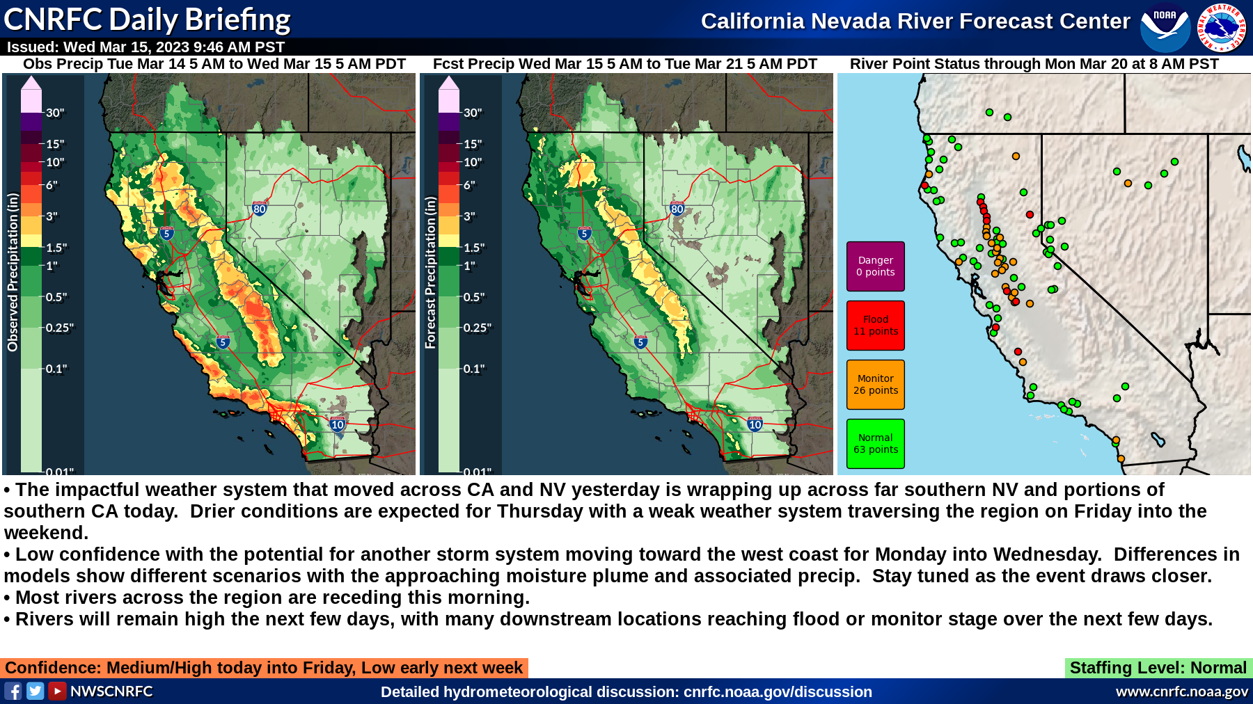
Summary:
- The impactful weather system that moved across CA and NV yesterday is wrapping up across far southern NV and portions of southern CA today. Drier conditions are expected for Thursday with a weak weather system traversing the region on Friday into the weekend.
- Low confidence with the potential for another storm system moving toward the west coast for Monday into Wednesday. Differences in models show different scenarios with the approaching moisture plume and associated precip. Stay tuned as the event draws closer.
- Most rivers across the region are receding this morning.
- Rivers will remain high the next few days, with many downstream locations reaching flood or monitor stage over the next few days.
Video (Twitter) of people trying to plug levee breaches by driving dirt-loaded Silverados into them and burying them there at Tulare.
8 Likes
1 Like
Summary:
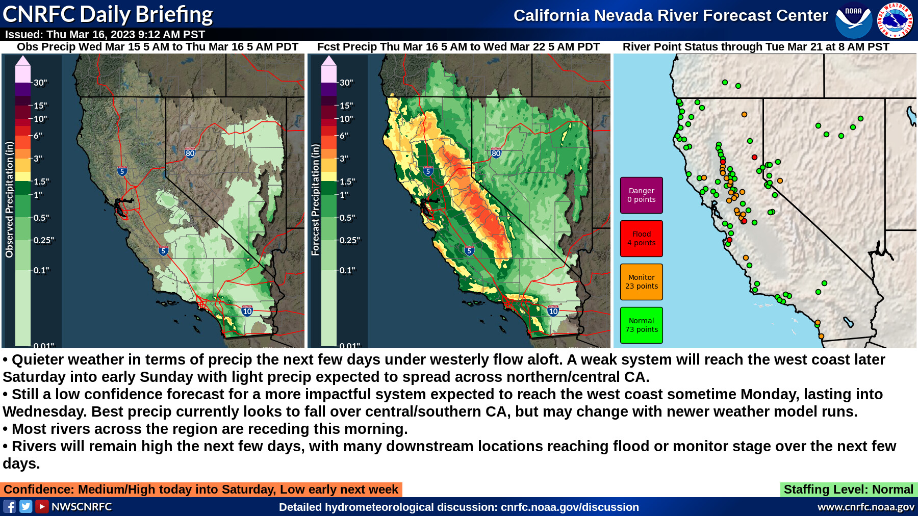
- Quieter weather in terms of precip the next few days under westerly flow aloft. A weak system will reach the west coast later Saturday into early Sunday with light precip expected to spread across northern/central CA.
- Still a low confidence forecast for a more impactful system expected to reach the west coast sometime Monday, lasting into Wednesday. Best precip currently looks to fall over central/southern CA, but may change with newer weather model runs.
- Most rivers across the region are receding this morning.
- Rivers will remain high the next few days, with many downstream locations reaching flood or monitor stage over the next few days.
Confidence: Medium/High today into Saturday, Low early next week
Staffing Level: Normal
Detailed Hydrometeorological Discussion: cnrfc.noaa.gov/discussion
Follow the link to CNRFC for the latest revised forecasts and guidance.
1 Like
2 Likes
Summary:
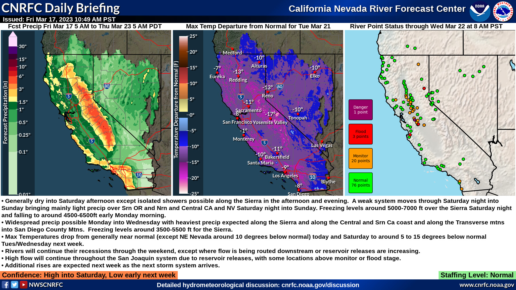
- Generally dry into Saturday afternoon except isolated showers possible along the Sierra in the afternoon and evening. A weak system moves through Saturday night into Sunday bringing mainly light precip over Srn OR and Nrn and Central CA and NV Saturday night into Sunday. Freezing levels around 5000-7000 ft over the Sierra Saturday night and falling to around 4500-6500ft early Monday morning.
- Widespread precip possible Monday into Wednesday with heaviest precip expected along the Sierra and along the Central and Srn Ca coast and along the Transverse mtns into San Diego County Mtns. Freezing levels around 3500-5500 ft for the Sierra.
- Max Temperatures drop from generally near normal (except NE Nevada around 10 degrees below normal) today and Saturday to around 5 to 15 degrees below normal Tues/Wednesday next week.
- Rivers will continue their recessions through the weekend, except where flow is being routed downstream or reservoir releases are increasing.
- High flow will continue throughout the San Joaquin system due to reservoir releases, with some locations above monitor or flood stage.
- Additional rises are expected next week as the next storm system arrives.
Confidence: High into Saturday, Low early next week
San Joaquin near Vernalis is forecast to overtop to Danger Stage on Mar 18 around noon. My impression is that LIDAR is being used to assess the threatened area. I think it also implies that a huge glut of water mass has been grinding its way north from the Tuolumne and the Merced. The Feather River has also experienced rolling warnings of water gluts that might be under constant observation using LIDAR and other sensors.
The Salinas River is cresting at Spreckles at this time and is forecast to subside below Flood Stage on the morning of Mar 20.
2 Likes
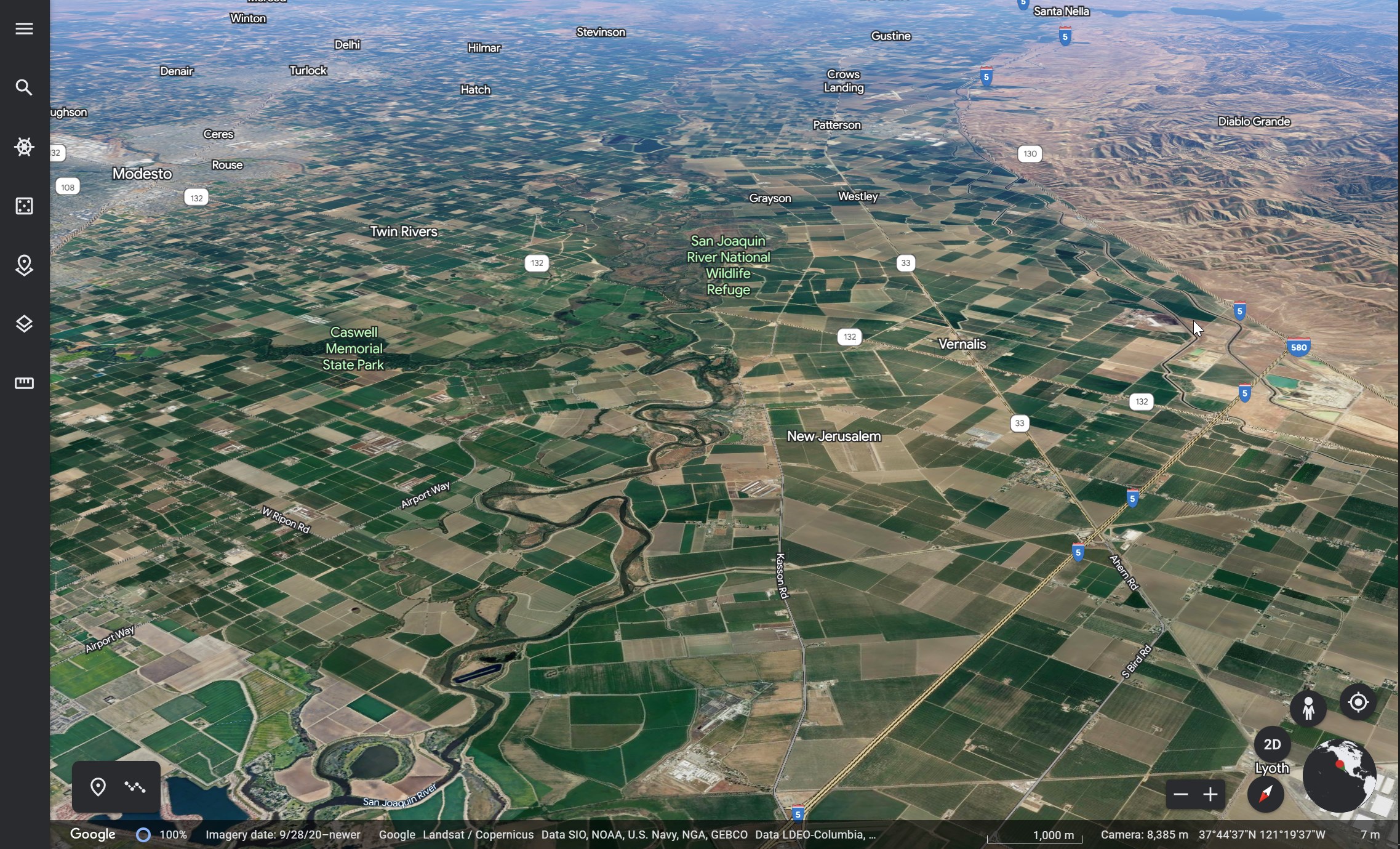
San Joaquin at Vernalis. Looking south by southeast at San Joaquin River National Wildlife Refuge. The Stanislaus River, passing left to right, through the City of Modesto and Caswell Memorial State Park, is a full partner in the overtop. Highways 5 and 580 meet on the right side of the image. The gagehouse is on a turn of the river in the center, at the crossroads of S Airport Way and Kasson Road.
2 Likes
View from firis Intel of the Tulare county levee breaks.
https://www.facebook.com/groups/talkofthehill/permalink/1414462509407318/?app=fbl
5 Likes
Second Round coming
2 Likes
Drone shots from Jan. Piper was a strong kickoff to this year’s flood siege. The ram is still at the gate, but these pauses give the sequestering assets time to shunt the overload. I think it’s reasonable to describe conditions that force evacuations in the thousands that last weeks as a Siege. Triage actions are responsible for some of these reservoir release evacuations and SAR assignments.
Cosumnes River Levee Repairs 01-11-2023 - YouTube
California Conservation Corps at Planada 01-13-2023 - YouTube
The cries of ‘bag’ and ‘got it’ are familiar to the California Conservation Corps. Corpsmembers past and present. Communication is an important part of how to safely and efficiently chain sandbags into place and construct sandbag structures to fight floods. During these January storms, Corpsmembers have taken their annual flood fight training into the real world and atop levees. The mission to protect homes, businesses, and critical infrastructure can be repetitive, exhausting, and just plain dirty. For these young adults, it’s a challenge they tackled without a second thought. (ed.)
Training Put to Use Protecting Merced Community of Planada - YouTube
1 Like
Summary:
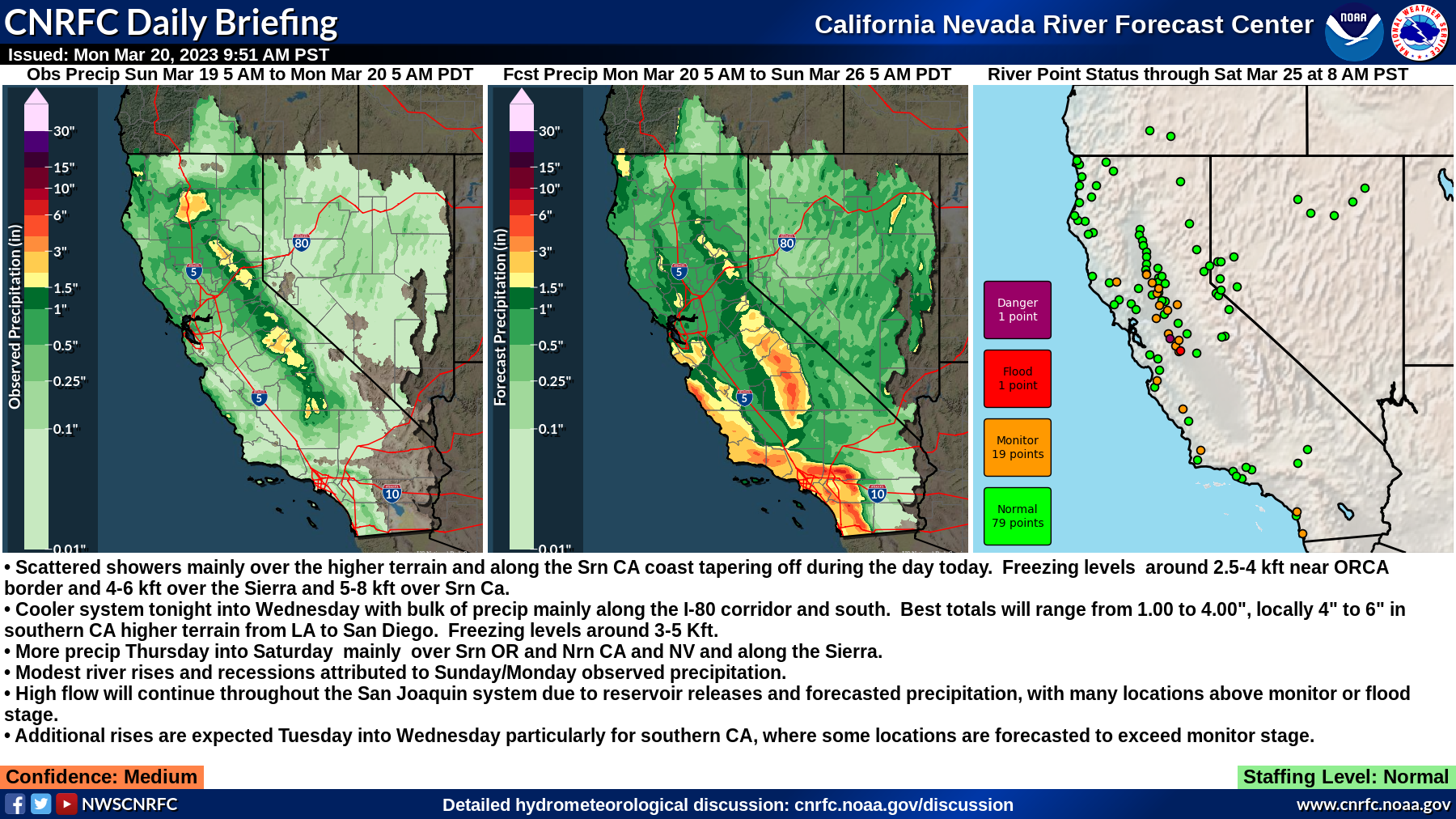
- Scattered showers mainly over the higher terrain and along the Srn CA coast tapering off during the day today. Freezing levels around 2.5-4 kft near ORCA border and 4-6 kft over the Sierra and 5-8 kft over Srn Ca.
- Cooler system tonight into Wednesday with bulk of precip mainly along the I-80 corridor and south. Best totals will range from 1.00 to 4.00", locally 4" to 6" in southern CA higher terrain from LA to San Diego. Freezing levels around 3-5 Kft.
- More precip Thursday into Saturday mainly over Srn OR and Nrn CA and NV and along the Sierra.
- Modest river rises and recessions attributed to Sunday/Monday observed precipitation.
- High flow will continue throughout the San Joaquin system due to reservoir releases and forecasted precipitation, with many locations above monitor or flood stage.
- Additional rises are expected Tuesday into Wednesday particularly for southern CA, where some locations are forecasted to exceed monitor stage.
Confidence: Medium
1 Like