These are a few Google Earth images of basic topographic issues that contributed to major floods and resource deployments on the coast in the winter of 2022-2023.
Russian River
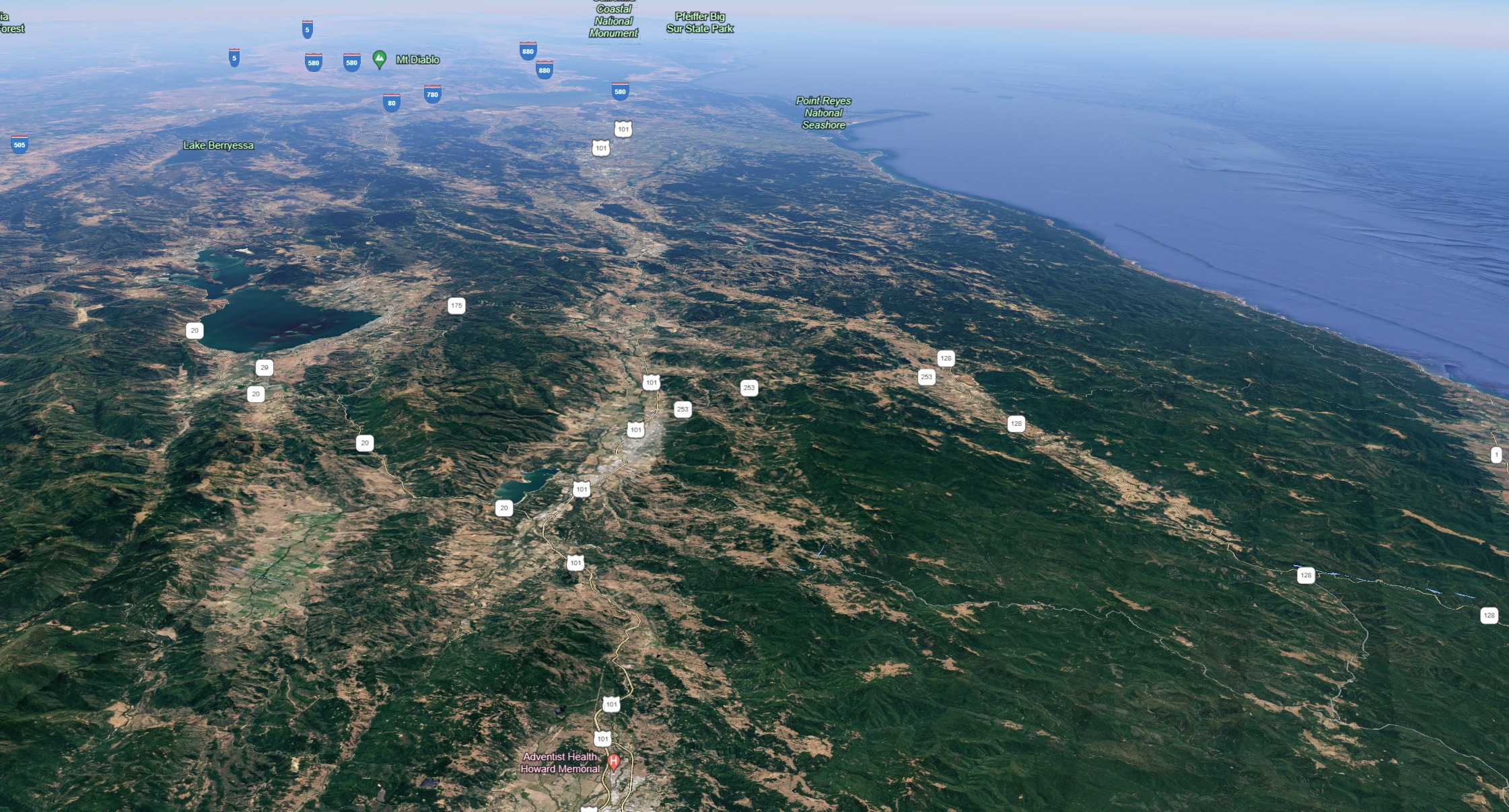
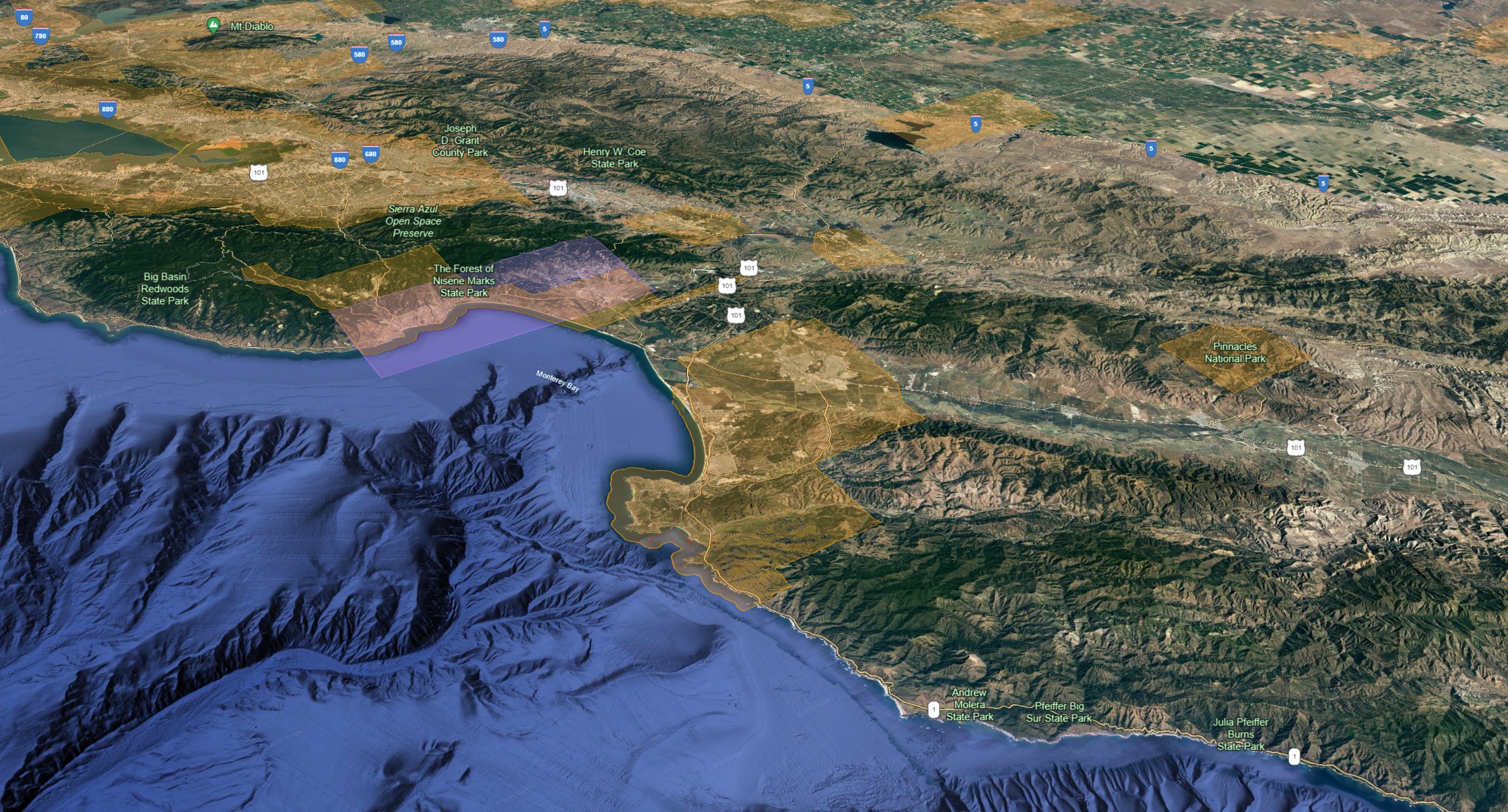
Monterey Bay
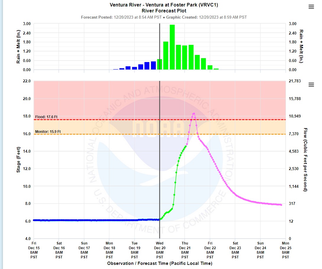
Ventura River

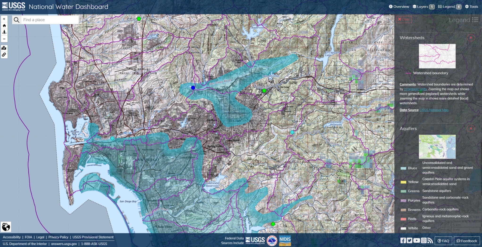
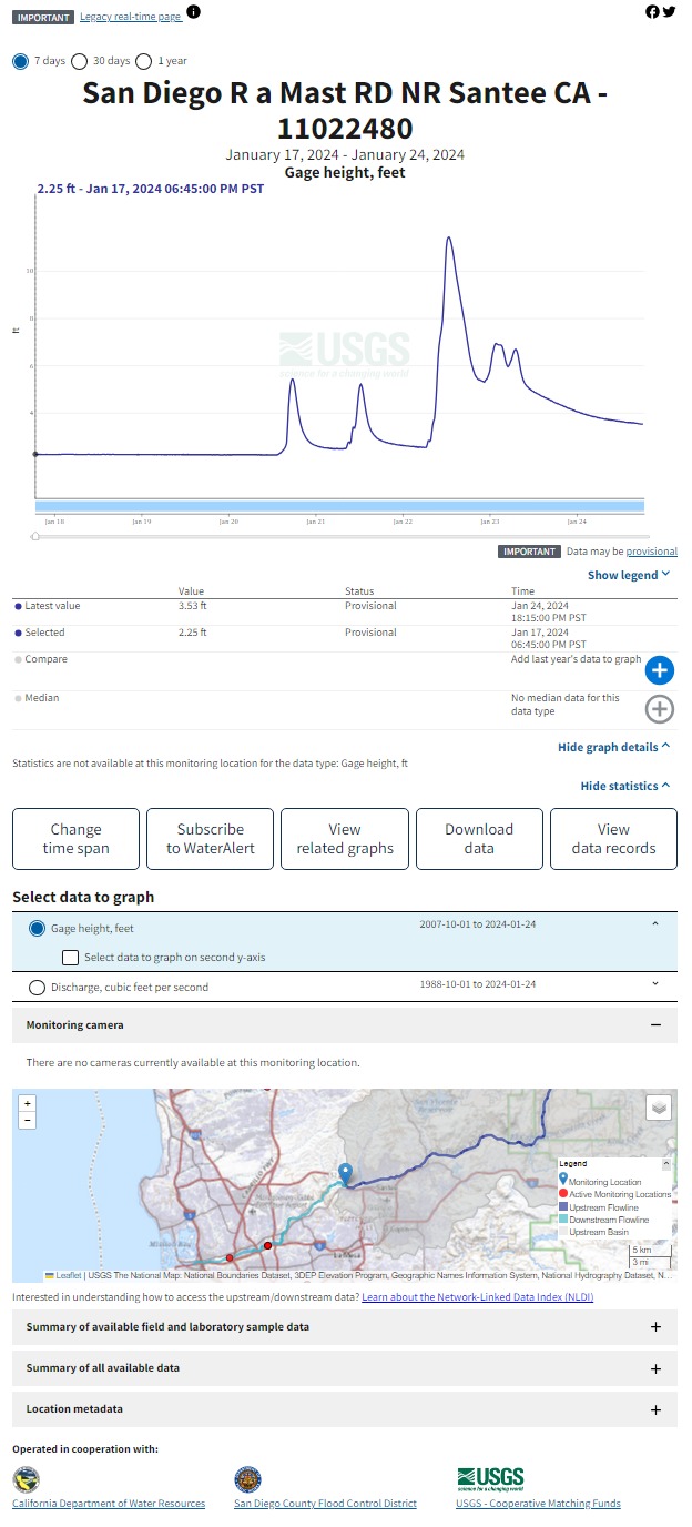
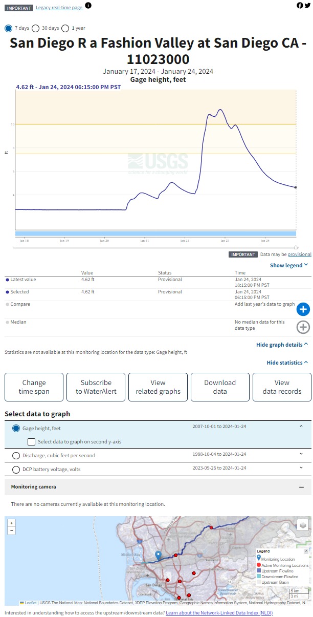
San Diego River

Yosemite Valley: Stanislaus, Tuolumne and Merced Rivers all went off the rails. Later, the Big Melt resulted in controlled dam releases that kept the San Juaquin River swollen for months.

Further south along the Sierras, Tulare Lake. Kings, Tule and Kern Rivers in the southwestern Sierra Range. All roads lead to Tulare Lake.

On the bottom of the image, the Salinas Valley tucked into Pinnacles and the Los Padres Range. Old Man Salinas River flows south to north, right to left, was fed with rainfall on the peaks in Santa Barbara and Ventura Counties and slowly built up until it flooded the entire valley from Paso Robles to Carmel.
CDOT Dec 19, 2023 Quick Map/Waze & CA-ANF Forest Service Road Closures Alert Sep 26, 2023
There’s basically no estimated time for the reopening of ANF’s main highway.
Northbound / Southbound 2 Full Closure from Mount Wilson Rd to 300 feet West of Upper Big Tujunga Rd.
Northbound / Southbound 39 Full Closure from 2 miles North of Crystal Lake Rd to Angeles Crest Highway, Route 2. From Islip Saddle/JCT SR 39 to Vincent Gulch Rd.

CNRFC Daily Briefing (noaa.gov) Wed Dec 20, 2023 9:55 AM PST
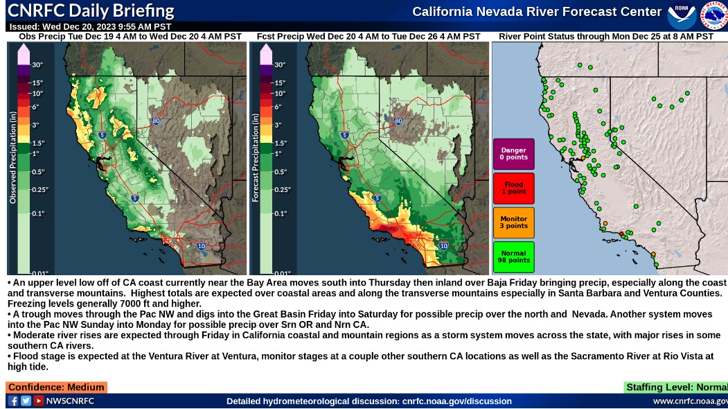
Summary:
- An upper level low off of CA coast currently near the Bay Area moves south into Thursday then inland over Baja Friday bringing precip, especially along the coast and transverse mountains. Highest totals are expected over coastal areas and along the transverse mountains especially in Santa Barbara and Ventura Counties. Freezing levels generally 7000 ft and higher.
- A trough moves through the Pac NW and digs into the Great Basin Friday into Saturday for possible precip over the north and Nevada. Another system moves into the Pac NW Sunday into Monday for possible precip over Srn OR and Nrn CA.
- Moderate river rises are expected through Friday in California coastal and mountain regions as a storm system moves across the state, with major rises in some southern CA rivers.
- Flood stage is expected at the Ventura River at Ventura, monitor stages at a couple other southern CA locations as well as the Sacramento River at Rio Vista at high tide.
Detailed Hydrometeorological Discussion: cnrfc.noaa.gov/discussion
It’s just been chins in the wind for Ventura County all year long.
LACoFD Technical Operations provides a well-produced intro to the fundamental elements of a Swift Water Incident, IC priorities and resource deployment factors.
“Swiftwater Command”, May 13, 2020
Ventura River Update: On Thursday, Dec 21st, rain over 1"/hr inundated roadways in Oxnard, Port Hueneme, a freeway ramp in Santa Barbara, and several blocks of mixed residential and commercial structures over the impacted region. The Ventura River crested at a little over 10 feet in the afternoon. An individual was rescued by hoist from the river bottom by Ventura City FD using an aerial ladder truck and ropes.
Overall, dramatic fall rates were recorded at several locations, but mitigation work (several outfits, including CalGuard engineers) and the particular pattern of this storm contributed to a relatively mild impact on the instrument at Foster Park. The area is generally expected to have a week to ten days of runoff before the next storm.
Anecdotally, the nearby Carpinteria gage is undergoing trigger point review for monitor and flood stage alerts.
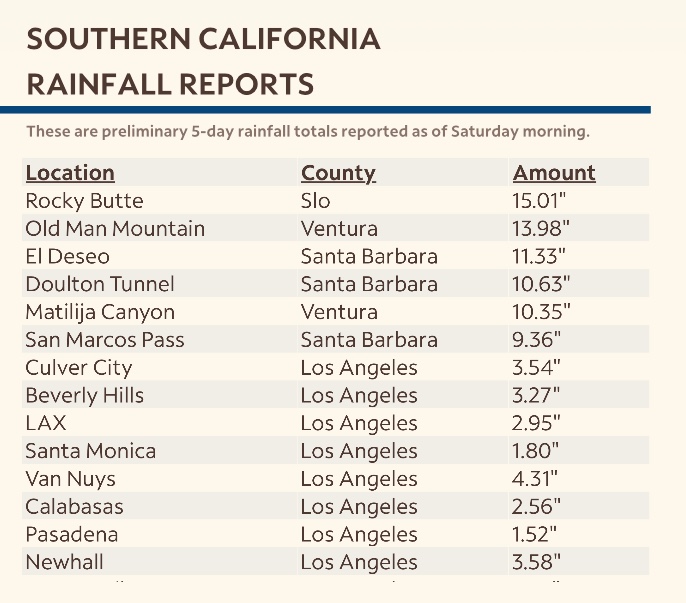
California’s flooding rains and heavy snows that killed at least 17 people have likely caused more than $30 billion in damages and economic losses, according to AccuWeather Inc.
The Pacific storms, known as atmospheric rivers, are estimated to have caused $31 billion to $34 billion of economic impacts through major flooding, widespread power outages, landslides, fallen trees and road closures, the commercial weather forecaster said…
I see a wide range of estimates out there, but there are a lot of factors to consider before landing on a very specific number because of confounding issues; including stalled Federal budgets and wage increases, unresolved liability disputes and international turmoil which impacts trade.
USGS Water Dashboard Jan 10 2024
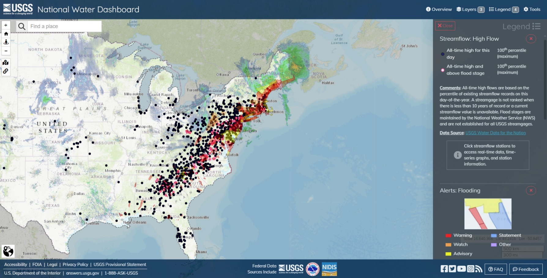
Major flooding across the Eastern Seaboard. Winter Storm Finn is forecast to continue having major impacts into the weekend. I don’t have solid intel, but I’d suppose there’s a fairly high number of IMT and USAR deployments going on.

5 Day Precipitation Forecast

Summary:
- Rounds of precipitation for most of the region this afternoon into early next week as several waves move through under moist westerly flow.
- The first wave will bring precip this afternoon through Saturday and the next more widespread system arrives Sunday through Monday.
- Freezing levels generally around 5500-7500ft over the weekend into early next week.
- Northern and Central California rivers will see increased flows beginning early Saturday, peaking at most locations on Sunday and Monday.
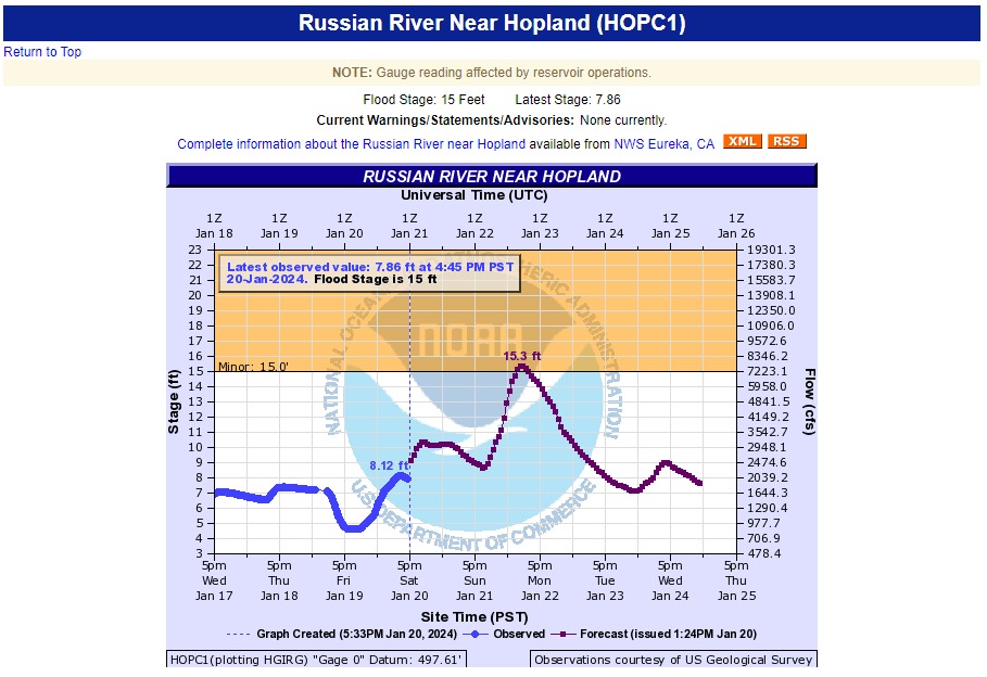
- Over the next 5 days, exceedance of flood stage is forecast on the Russian River at Hopland, and exceedance of monitor stage is forecast at several locations along the north coast and Sacramento River system.
- Weir flow is expected along the Sacramento River at Colusa and Tisdale weir. Forecasts are just below the weir crests at Moulton and Fremont weir.
Confidence: Medium
Staffing Level: Normal
Detailed Hydrometeorological Discussion: cnrfc.noaa.gov/discussion
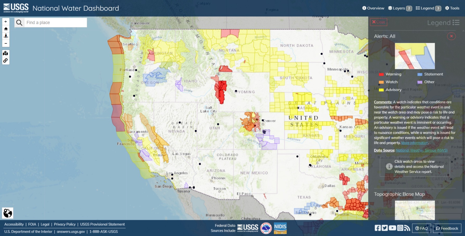
Winter Storm Watches in the Sierra. Dense fog in the lower Central Valley. Flood Watches in place for the Russian River valley and surrounding areas.
Hydrological Outlooks for the SF Bay Area and Monterey County.
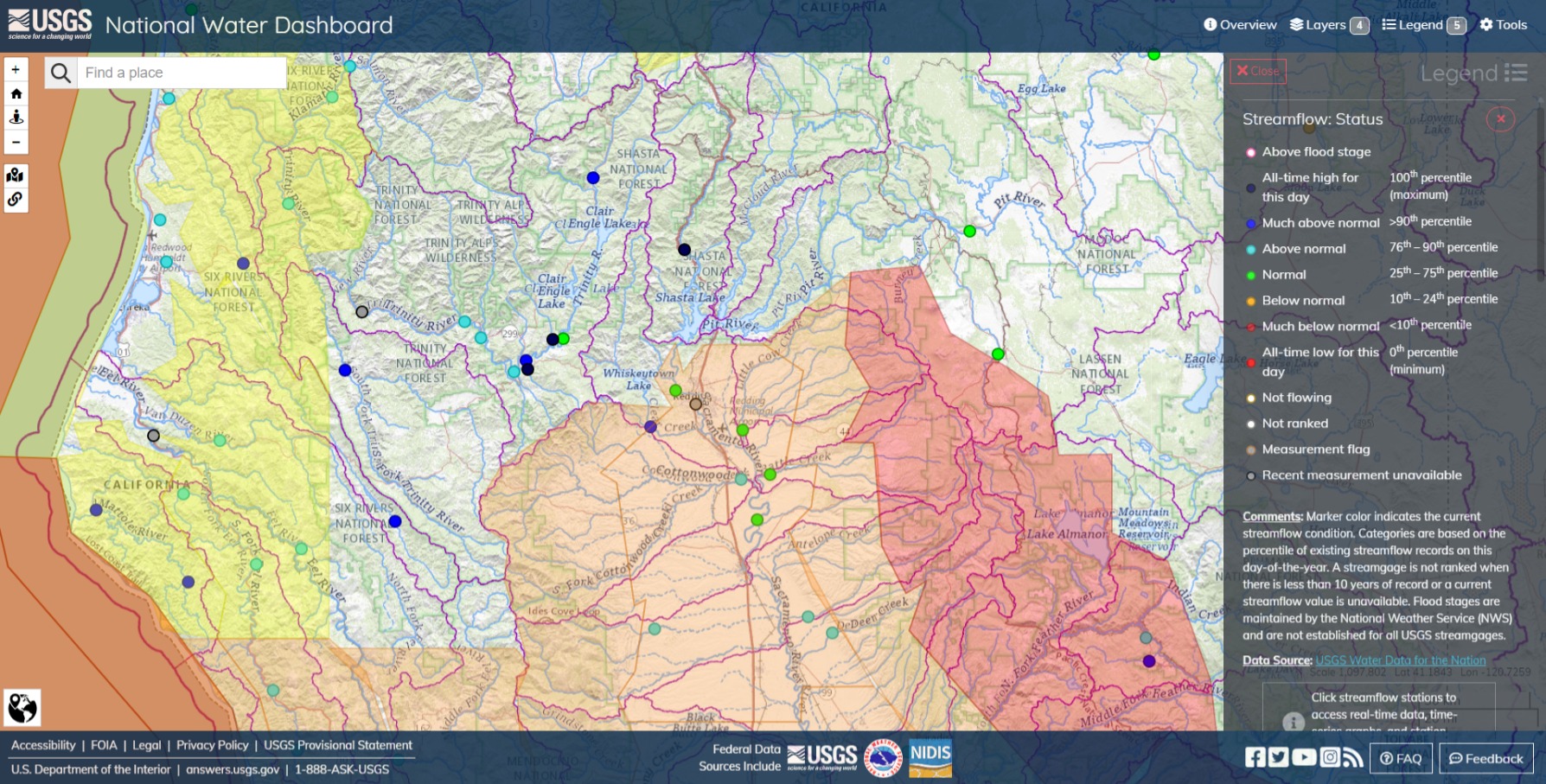
USGS instrumentation throughout the San Francisco Bay Area
indicates that shallow soils on steep hillslopes are
approaching saturation. This coupled with the forecasted
precipitation means widespread shallow landslides are likely.
Full Text: NWS Alerts (weather.gov)
Update: Fri Jan 19 2024 11:30 AM PT

Flood Watch issued January 19 at 9:41AM PST until January 23 at 4:00AM PST by NWS Sacramento CA
A series of warm weather systems will bring heavy rain to interior
California this weekend. The heaviest rain is expected Sunday night
and early Monday morning. This will cause significant rises to small
streams, including possible flooding, especially for streams
draining from the foothills into the Valley.
WHAT…Flooding caused by excessive rainfall is possible.
WHERE…A portion of northern California, including the following
areas, Central Sacramento Valley, Motherlode, Mountains
Southwestern Shasta County to Western Colusa County, Northeast
Foothills/Sacramento Valley, Northern Sacramento Valley and
Southern Sacramento Valley.WHEN…From Sunday afternoon through late Monday night.
IMPACTS…Excessive runoff may result in flooding of rivers,
creeks, streams, and other low-lying and flood-prone locations.
Creeks and streams may rise out of their banks. Flooding may occur
in poor drainage and urban areas. Low-water crossings may be
flooded. Storm drains and ditches may become clogged with debris.ADDITIONAL DETAILS…
- Urban and small stream flooding from prolonged heavy rain
through Monday. Cottonwood and Cow creeks over Shasta county
and Battle creek over Butte county may be at higher risk for
flooding.- http://www.weather.gov/safety/flood
Instructions
You should monitor later forecasts and be alert for possible Flood
Warnings. Those living in areas prone to flooding should be prepared
to take action should flooding develop.
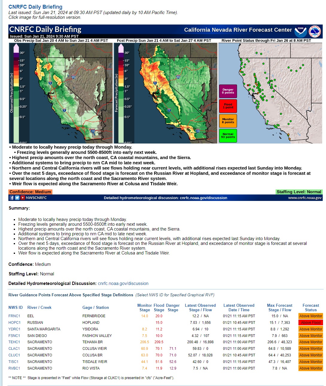
Summary:
- Moderate to locally heavy precip today through Monday.
- Freezing levels generally around 5500-8500ft into early next week.
- Highest precip amounts over the north coast, CA coastal mountains, and the Sierra.
- Additional systems to bring precip to nrn CA mid to late next week.
- Northern and Central California rivers will see flows holding near current levels, with additional rises expected last Sunday into Monday.
- Over the next 5 days, exceedance of flood stage is forecast on the Russian River at Hopland, and exceedance of monitor stage is forecast at several locations along the north coast and the Sacramento River system.
- Weir flow is expected along the Sacramento River at Colusa and Tisdale Weir.
Confidence: Medium
Staffing Level: Normal
Detailed Hydrometeorological Discussion: cnrfc.noaa.gov/discussion
Nothing too alarming so far. Hopland is looking at a crest tonight of 15.1 ft, just into Minor Flood stage.

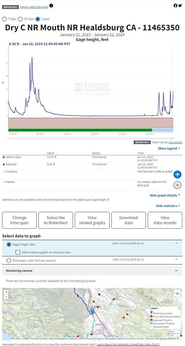
Here’s a comparison to last year at Healdsburg, for reference.
I have nothing about debris flows from last year’s fires, but they had pretty lively weather all year, so I’d imagine an abundance of caution is called for.
Sacramento upper valley and foothills. The Trinity River is running high, but there is yet a lot of capacity at Shasta and in the system southwards. Flash floods are the thing. Mostly small creeks, steep inclines, known low-level crossings, etc. As was noted by NWS for the Bay Area and Central Coast, and is probably getting to that point in the year for other regions, some of the grounds are reaching soil saturation levels, increasing the risk for slides. Naturally, there will be a lot of eyes on the levees, especially the newer works and known problem spots.
Mon Jan 22 2024 7:30AM PT

Flood Warnings: Russian River southwest of Healdsburg, Laguna de Santa Rosa in Sonoma County. Alameda Creek in the East Bay. Half Moon Bay and the Santa Cruz Mountains.
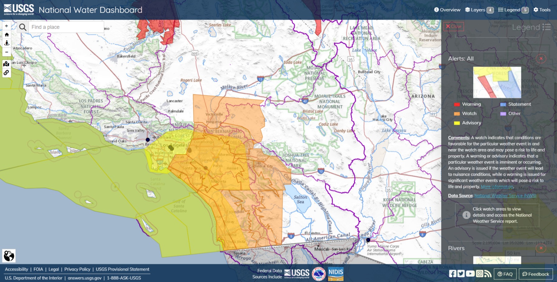
Watches for the 'Dino, OC, Oceanside, Cleveland NF and San Diego County.
**GOES-19 Wx Satellite **
https://www.axios.com/local/denver/2024/01/22/colorado-weather-satellite-kennedy-space-center-goes-u
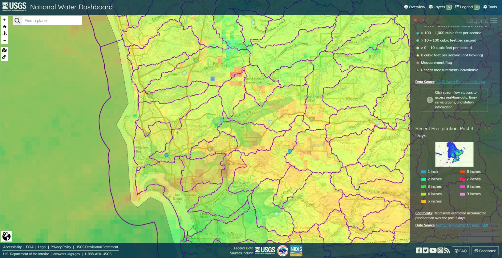
Offshore winds and upwells wrung the clouds against elevations of 1000+ ft in a few miles between Gillespie Field, La Mesa and Lemon Grove for 5" of rain within a few hours on the San Diego River Watershed and Estuary, sand and gravel aquafers under river that quickly overwhelmed the system, with little catchment on the downhill side. The river’s course meets the separate aquafer buffer south of Fashion Valley with an elevation line between.