Check with someone at your agency?
It’s part of their CAD system. General public does not have access to this program.
1 Like
It’s the latest tracking system. It uses multiple cell, radio frequencies, and sat. for the tx of the system. I can’t find the link I had seen earlier in the year that talked about it.
1 Like
Its a Wildfire Analysis program developed for CAL FIRE. There are two versions, the one you are seeing screen shots of is the “tactical” version called FiResponse. You have to be a state employee with authorized access. Mods…Better for a different thread I think
3 Likes
This is not part of the AVL / MDT program although it does reflect some of that data in the incident maps
Yeah a picture without context lends to a lot of questions @CALFIREBC lol.
Like other have posted CAL-FIRE made an enterprise investment with Technosylva.
This includes the Wildfire Analyst fire modeling and a whole host of other resources like a web COP and mobile COP.
I was one of the user acceptance testers for the the Tactical mobile COP called FiResponse as @Chiefrog mentioned.
It is leveraging AVL data from their existing system that also fed the SCOUT program.
WFA/Technosylva has some very cool features at the enterprise level like providing an automatic fire prediction at entry of a fire in the CAD, spits out some initial intel on infrastructure and structure threat etc. Will recommend augmenting response based on weather/fuels etc.
Like any computer program its garbage in garbage out. Depending on where the dispatcher puts in the fire location which depends on reports from callers the initial run can be a bit off but with subsequent reports especially with on scene resources updating the models can be refined.
We have echoed this from the SCOUT side of the house and from FireScope EIT that there needs to be a minimum data set that is shared across the state for response because some folks use Tablet Command, CAL-FIRE with Technosylva, we use ATAK, FEDS with Intterra and now trying ATAK etc. All of these disparate programs have the ability to visualize a common feeds of data and exchange data. In my opinion at a minimum is AVL, some basic fire perimeter stuff etc.
6 Likes
If any agency is interested in a flying UAS for all hazard response and wants to check out UASTool for ATAK let me know. It works on the smart controller for DJI and Has comms with Autel drones and a few more using an android tablet/phone. In LTE denied environments use mesh networks for SA markers and video depending on pipe you choose. Augmented reality of markers, your team members, object detection and have any operations maps as an optional basemap. Remote gimbal control and tasking are also features. Full MISB/STANAG georeferenced video and the ability to port in other aircraft video is the cherry on top. Here is a video from a few versions ago and its only got better from there. UASTool
1 Like
Are BC-types using phone boosters and/or hotspots with external antennas in their rides?
Maybe you guys already have this covered, but a hotspot or a phone in a cradle booster parked on top of a hill, with some kind of mesh network to get to field units nearby, might make something out of nothing.
I use one in my mobile business, and often times where a phone in my pocket will have no usable signal, putting it in the cradle in the truck even at the same location will boost the signal enough to make it completely workable.
We do not but are looking at whats out there. Im really excited for this company https://lynk.world/ to answer this need.
Satellite everything has been tried over the years and always ends up too expensive.
I feel like the tide may finally be turning on that, but it always seems to be just out of reach.
A couple hundred to a couple thousand in hardware per vehicle can get you a lot better coverage with existing cell networks.
A good idea also would be to have some sort of gateway that aggregates all 4 (3?) carriers since we know some areas one will work where the others don’t. ATT, Verizon, Sprint/T Mobile.
Cradlepoint does that as well as sierra wireless but you have to have coverage.
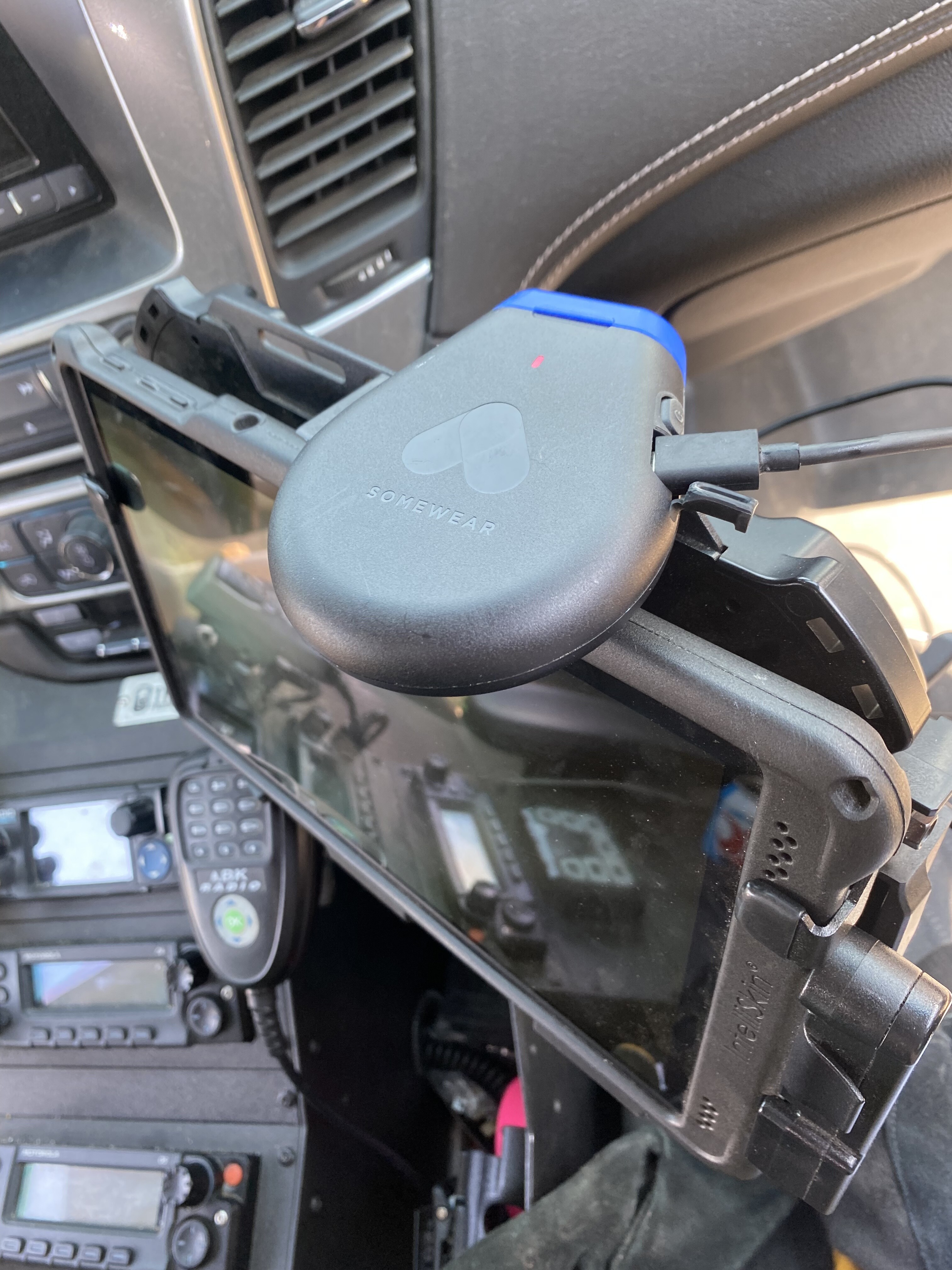
Iridium has a deal with DHS that they are going to pass on to state/local govt for the use of their network for the somewear labs devices which are ATAK compatible. 800 bucks a year for unlimited use. That is a very reasonable cost considering all the things you can do over it. DHS still working on the details but this is a very cool deal.
1 Like
@DC3075 deploying a somewear on the KNF-River Complex
2 Likes
So this is not like emerging tech really but more about distributing data at the ICP specifically the map products that the team produces.
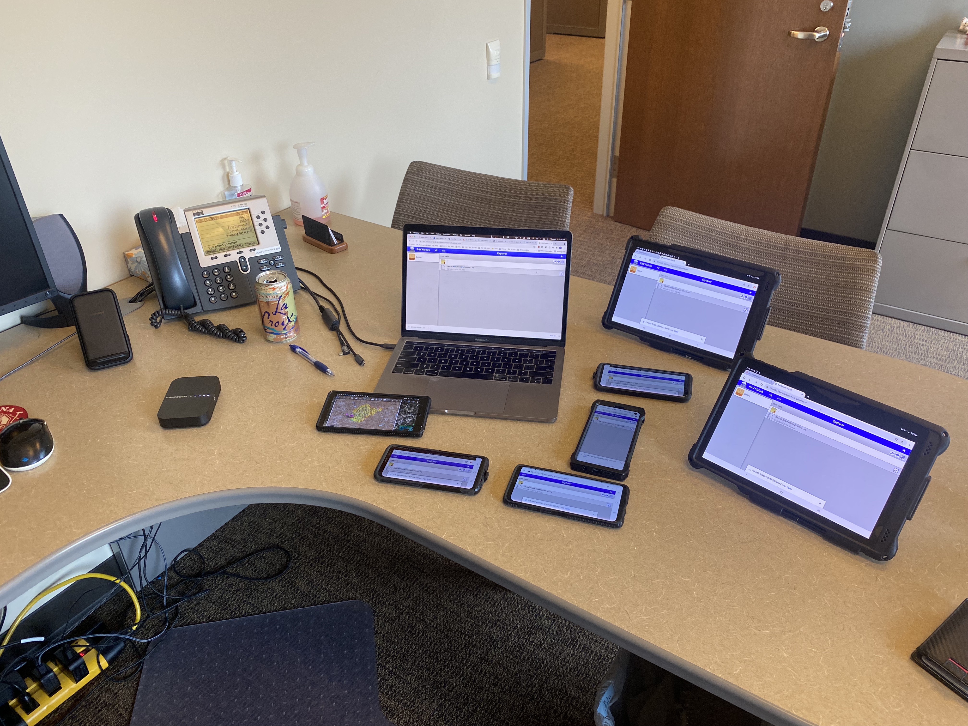
As you may know I am a map nerd. I create data packages for fires and put them on a google drive for sharing. I hear a lot of times that cell service is bad, the wifi in camp is locked down or is poor etc. and they cant get the map products from FTP or from my google drive.
What needs to occur in camp is Local Area Network (LAN) file server. I have seen some Fed Type 2 teams doing this sort of thing because many times they are posted up in the middle of nowhere.
Like most things techy you could go extreme with a LAN with a file server on dedicated computer and multiple wireless access points around camp. If you have the IT support and hardware go for it. If you dont you could spend 39 bucks on this little device from RavPower called the FileHub There are other companies that make these and they also call them Travel Routers across the industry. TPLink is a popular one. Look for one that has an internal battery or can be powered by USB so you arent limited on where you put it.
This little device creates its own LAN with wifi, you can plug in an SD card or USB stick with your map products, kmls etc on it and have people connect in camp and download the content locally. I hooked up 9 devices simultaneously in my office and downloaded a 100mb ATAK Data Package within seconds. These have an internal battery and you could post them up in camp where ever you wanted.
People hook to the network then you could have a QR code that points them to the server. You can also use the RavPower App on your phone, either way you are not relying on a crappy or overwhelmed cellular connection or fiber/copper internet connection with not enough bandwidth to get the data you need. You could put many of these around the briefing area, feeding area etc to get the products out.
Just wanted to throw this out there to the Team IT and SITLs if they are struggling with getting digital products out to folks.
7 Likes
I’m no ITSS, but don’t a lot of routers have a USB port that can act as a file server? Sounds like a good use of an older router.
I think at one point I bought a WiFi USB drive to do exactly this, but I never got around to actually using it for that.
@Fish yup lots ways to skin this cat. The little travel routers are pretty sweet because they can be powered either by an internal battery if they have them or a USB battery brick so you dont have to find a power source to put it somewhere.
2 Likes
I’d love to know how to get dozer lines drawn too. I’ve spent hours drawing them in by hand from the ops maps.
1 Like
We do this on TREX events using a Windows Laptop. They all have a setting that allows them to be used as a webserver - all you need is a wireless router and then a folder on the Desktop becomes something like a FTP site. Have also set it up on Android tablets. Takes a ton of pressure off of often-strained local internet. I’ve got a writeup somewhere is anyone is interested.
2 Likes
I’m interested.
Type 1 Incidents have IT services but not sure they are getting tasked to serve this need. As our incidents are getting larger and larger and ops folks are using more and more of digital data this really is a need. Hoping the SIT community can work with the IT folks to make this happen. Until then think about the ideas posted here to make your own adhoc file server.
Hi Zeke. Based on your reply to me (thank you for that) about the dozer lines I figured out how to use QGIS to extract the “event line” AKA dozer lines into caltopo. The lines show up as a thin red line by default. I see how to change a single line to X’s like dozer lines are shown, but there are dozens… hundred(s)?.. of individual data entries to change. I can’t see how to change them all at once. Any suggestions? I’d be happy to write up a how-to with screen shots or even a video on this process. [Edit: Aha! Found the Bulk Ops at the bottom of the list… ]
2 Likes