https://www.arcgis.com/home/item.html?id=ecb248b2010a46efa5c3589f3333d189
Link is in bottom-right corner.
3 Likes
Remote sensing Sounds like my cup of tea! When you say spreadsheet are you talking Excel? I will have to look again at the classes list to see if those skills are addressed. 6 trimesters. If you have any recs for platforms please think of me and send my way! Thank YOU!
@heart4paso like Zeke said lots of reps. My MS is in GIS with a heavy concentration on remote sensing. GIS as a whole is soooo broad. Making a map although really cool is such the surface, the good stuff is the analysis and display of data. Have fun! If you ever want to read my research paper on using remote sensing for automated initial damage assessment let me know.
3 Likes
If you are going thru a full program you’ll get all the good stuff. Yes, Excel is the standard. I recommend learning QGIS. It’s free, which will be nice once you are no longer getting the free student licenses and have to pay Esri $1,500-$5k/year to have all the tools you got used to having. Also, it runs on a Mac!
2 Likes
Absolutely yes please!!! I will PM my email.
Here everyone can get a good read when they are having trouble falling asleep.
8 Likes
Gonna say something sexy in excel… Pivot tables!
3 Likes
Oooh the power of a pivot table never fails to blow me away.
2 Likes
Courtney Aviation has flown the Oak Fire fire 4 times since NIROPS captured the only publicly-available IR data last night, but Courtney’s data is not available to the public, so I have to put out maps in my reporting that are almost 12 hours old. I got a call from a hotshot friend who was rolling up on the fire last night. They were looking for intel, didn’t have access to NIFC EGP - didn’t even know it existed.
I have yet to hear a good case for why making the latest IR data available as broadly as possible is a bad thing. If I was evacuated from this fire, I’d like to know the fire hadn’t moved toward my house in the past 24 hours, and I’d like it if my hotshot friend could open their phone and see the spot fires (that have been already mapped and are sitting on a server at NIFC) in their division. Free the data.
16 Likes
Yup, yup and yup. FIRIS has proved over the past 2 years that open data works. Hoping USFS and CAL-FIRE will follow in OES direction with sharing the wildfire perimeters openly and timely to EVERYONE to ingest as they see fit.
5 Likes
The McKinney Fire is a perfect example of why we need timely, public access to good intel. In absence of quality data, public are sharing VIIRS data broadcast via apps like Firemappers and Watchduty that is wildly inaccurate.
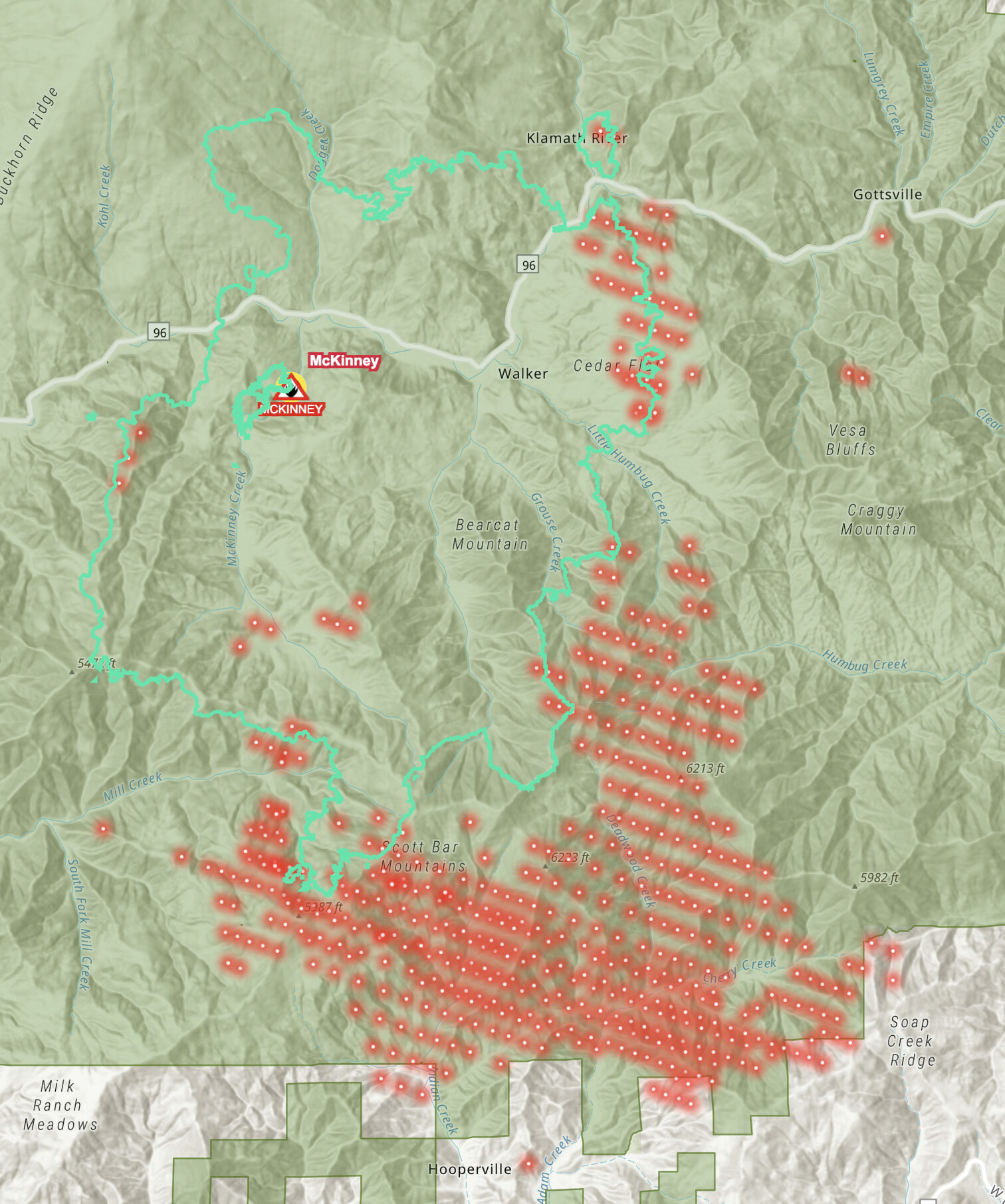
Red dots are VIIRS. Green line is actual fire location.
12 Likes
Cool application for increasing comms/SA and network for TAK.
3 Likes
I work on the CAL FIRE incident map. I’m interested in hearing about any additional layers we could add to the map that are accurate and timely and that we’re legally allowed to use. VIIRS is obviously a liability which is why we’ve never used it. I’m an IT guy and don’t know all the in’s and out’s of who owns what but hit me up if you have any suggestions.
1 Like
@neverborne can you explain by what you mean by “cal fire incident map”. Are you saying the incident produced products or Cal Fires Enterprise deployment of Technosylvas Tactical Analyst application.
Ah the web app. Your brining in the daily wildfire perimeters. The agency gets multiple updates on many fires from a variety of sources. Cal OES Firis is public. Your agency also has internal data from contracts like courtney. They traditionally have not shared that publicly until it goes out as part of a daily perimeter.
2 Likes
The NIFC feature service, which AJ is talking about as the daily wildfire perimeters, is getting more and more useful. It is great to see the FIRIS and Courtney IR products getting quickly digested and turned around for the public via the feature service.
1 Like
Thanks, I’ll look into it. The sheer volume of hits we get has taken some layers down immediately when we’ve tried to use them, so it would have to be something that could handle the load.
If there is a way to be able to bring in the NIFS (National Incident Feature Service) layer from NIFC, it would be cool for users to have an option to turn on or off control lines (Dozer, hand, road as line, completed line). The data isn’t always very good in first few days or week of a large fire, but later in the incident, it gets really good, and shows the public just how much work is getting done. I hear what you are saying about the shear volume of hits. It might be necessary to have a parallel service you host so you’re not taxing the NIFC services.
I think recent fire history (like past 5 years) would be really useful.
A structure layer would be nice. The Microsoft structure layer in CalTopo is an easy way to see how close a fire is to WUI. Maybe have it set to display at scales closer than 50k, or something pretty close-in.
I like how clean it is right now, though. Seems like it could be good to maintain a simple version, with option to click thru to more detailed map.
3 Likes
Yes the event point, polygon and line features with labels would be cool, put in the evac zones, shelters etc would be great.