TAK Information-

Hi all just wanted to share some info on emerging tech for fire use.

Over the last 2 seasons the Android Team Awareness Kit (ATAK) has made its rounds to a handful of fires as a beta program. It was originally brought to the USFS and Prescott Fire Dept. following the Yarnell Hill Fire Fatality as a potential solution on tracking firefighters. See the articles below. It really had not grown legs but for a very small group of very dedicated folks really wanting to champion this. It made it on to a couple fires to demo in 2017 but last year we really made some progress getting live spatial video into the program on the Mendocino Complex and the Camp Incident. Additionally the State of Colorado had been testing it for the last 2 years.

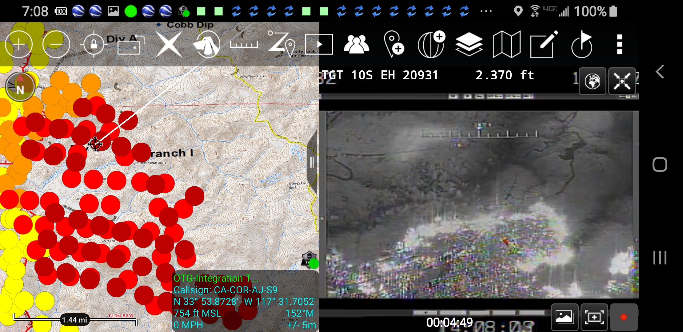
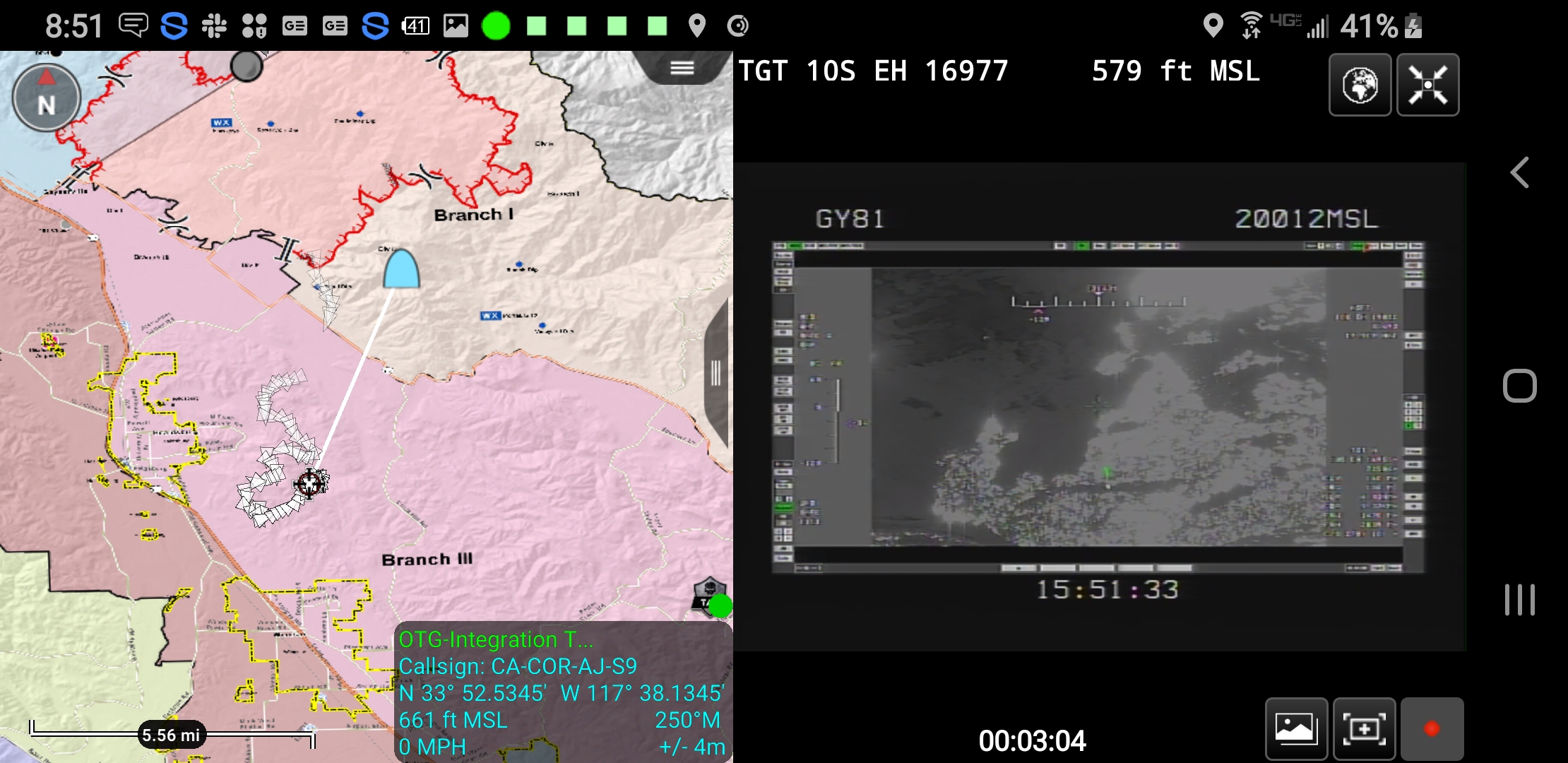
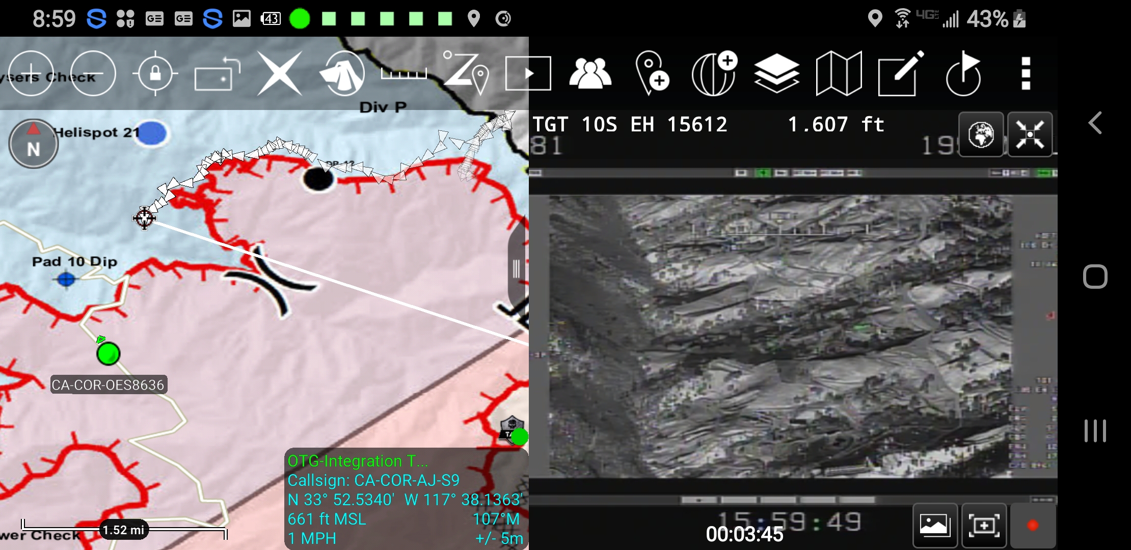
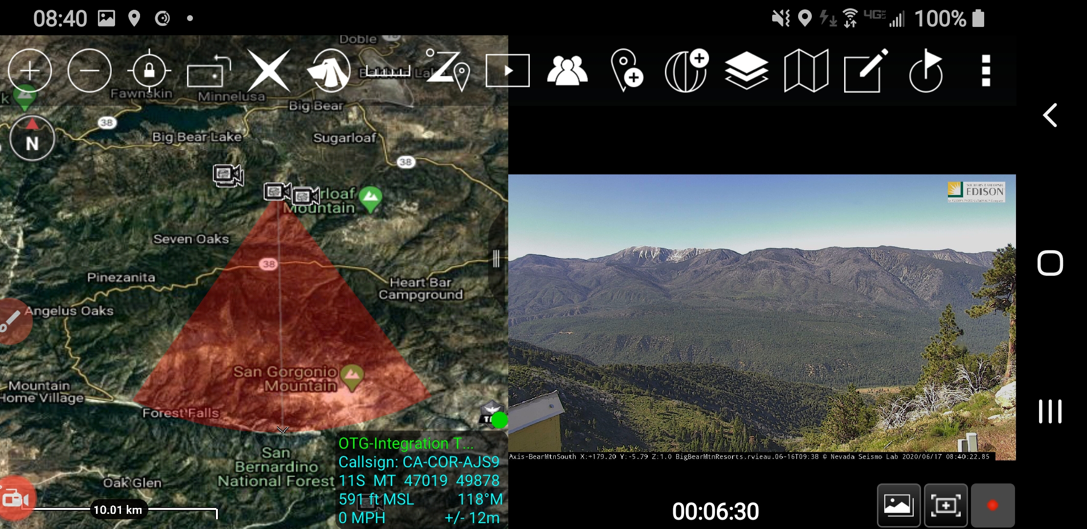
This post would be way too long to explain all that ATAK does but know that its out there and hopefully coming to you soon. I have put a some links on videos about ATAK and its uses are very broad as a true all risk tool. With connectivity we can track your location, stream live spatial video from aircraft, collaborate on a number of things.

The first is a clip of the FIRIS aircraft on the Tenaja Incident last week showing some dozers cutting indirect line and a crew firing behind them. This video wasn’t playing live because we don’t have that piece dialed in yet but the functionality is being worked on for the FIRIS project…

Next video was posted on the Walker fire on the PNFs facebook page showing what we can do with the MQ9. This has been done on 3 incidents now. ATAK will even take video from small DJI quad copters.

Check out the Emerging Technology video Redirecting...

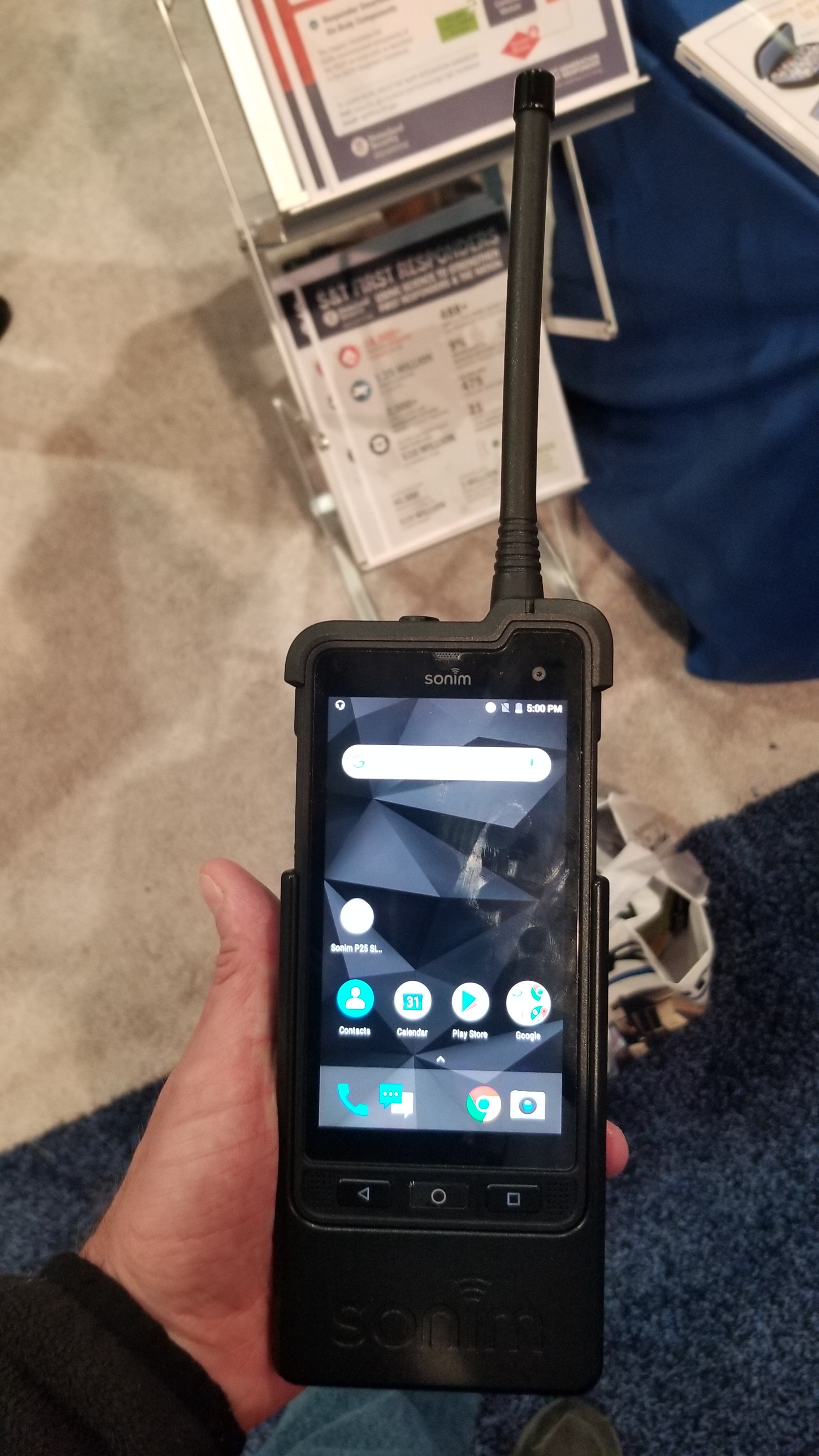
Our biggest hurdle is the connectivity out in rural areas. I believe we will have that solved in the near future with the low earth orbit communication satellites coming from companies like Space X, Ubiquitilink and Oneweb. We can do this now with MANET radios but they are very expensive and dont provide widespread solutions.

Below are a variety of links on the history of this tech coming to us. I want to thank Eric Aselin from the U.S. Forest Service and Dave Zader from the Boulder Fire Dept. for their continued push of this platform. We wouldn’t be where we are at today without your persistence. Also a big thanks to David Tally at PAR Govt. for his unwavering support with Team Connect server for ATAK and the team at the Hap Arnold Innovation Center at March Air Force Base for our video solutions.

AJ

https://www.dhs.gov/science-and-technology/news/2017/11/17/snapshot-atak-increases-situational-awareness-communication

14 Likes

Here is a little press on the FIRIS. Geospatial live video from these types of platforms in ATAK are game changers.

2 Likes

another powerful tool.that comes out next month for quick maps that can be used in ATAK. Orthomosaics were made on the Camp incident that took a couple days. The team did an amazing job but it required a lot of labor and offsite computing. This is gonna reduce the turn around time.

Awesome stuff AJ! This is some of the more important things that we need to keep investing in! I wonder how much my agency is backing these ideas with support, particularly money?? USFS. I know press is all over OCFA right now, and Ive seen some stuff from CAL FIRE? Where are we at federally with tracking of resources?

Well you have a directive to track all “resources” on a type 1 incident by 2021. Your agency is still debating what a “resource” is. I think the right mindset is gonna prevail. Your agency has seen ATAK right up close. About all I can say. Its a big ship doesnt turn on a dime.

As far as CAL-FIRE they dont have a directive but already have a robust AVL for their equipment. Its the dismounted from the apparatus solution we need. CAL-FIRE is definitely engaged and looking at all this stuff and has seen ATAK up close and personal.

Im gonna add that all this stuff is awesome but without solid connectivity its somewhat worthless. IMHO the connectivity has got to be celestial based. I dont want cell towers up in national parks and pristine areas as much as the agencies that manage those lands. Hopefull the tech thats coming from Starlink and Lynk and oneweb/iridium is going to change that. Iridium can already push location but its not robust enough to push rich content like video.

4 Likes
4 Likes

Some.pics of ATAK.platform and ops.maps on Kincade and the MQ9 video feed. Hoping ATAK becomes a normal platform for use in the future.

3 Likes

Here is a cool graphic with the power of ATAK. You can track the sensor point of interest from an imager. Could be a manned aircraft, small uas or in this case the Cal Guard MQ9. This can be done in real time giving you a way get a near real time perimeter. Ultimately an imager that is panned out will just draw a polygon of the fire based on the IR image. That tech is here in beta format but until it becomes mainstay this is a good second best.

2 Likes

Wow man…the information you shared is awesome…Thanks for sharing!

I have it on good authority that the following technologies are being considered or used;


the above software is slated to be used on desktop/laptop and tablet/convertible PCs. and ATAK will be deployed on android devices. they already have a LMR that has an integrated Android tablet. these are being tested right now. they plan to use APRS/MANET to allow for communication in otherwise radio/cell dead zones. firstnet is integrated into this project. but that roll out is slow and inconsistent across the country.

this tech might help but they aren’t looking at it right now.


JLENS can be used as a kind of airborne radio relay (VHF Repeater) and video platform.


the above is an actual picture of one of the test radios

1 Like

abro71 who are “they”?

To address your links in order.

LLDRS/NICS/SCOUT has been used for over a decade now. It never really got the total adoption I think we hoped for in CA. I am still disappointed that FEMA never grabbed NICS as a national COP, big missed opportunity. The code is still active at MIT Lincoln Labs for NICS NATO and WICS is running their version RAVEN. SCOUT is NICS code for OES/CAL-FIRE and they are looking at a heavy lift in enhancements. Im excited for this uplift.

As far as ATAK is concerned there will be some changes soon that will allow much easier access to the application. You will still need to decide how to deploy a server or use Team Connect. So thats really great news for accessibility to the product. Also ArcGIS MISSION is crawling along in development and is a partnership with PAR Govt the developers of ATAK and ESRI. This is supposed to be ATAK core in an ESRI GIS environment. Fingers crossed.

Networks on fires. All things have been discussed from every possible angle. This is not an easy cat to skin when we are talking low level aerial nodes like a JLEN in the proximity to tactical aircraft. I think anything aerial is gonna have to be above tactical aircraft. MQ9 will have cellular capability soon. MANET from aircraft was actually used on the Walker fire last year to display the USFS Cobra video right into an ATAK device on the fireline. MANET has its place for certain applications. It aint cheap technology but is really nice big pipe of bandwidth to send content rich material like video. I think the big lift will be cell from space like lynk is going to try and do and sat from elon musks starlink and others like viasat, oneweb, iridium and many others racing to space.

The Sonim Sled will be a disrupter for sure. A friend of mine testing it in Region 3. A link below that explains what this attachment does to a regular XP8 phone.

https://urgentcomm.com/2019/03/05/sonim-bob-escalle-demonstrates-capabilities-of-sled-enabling-lmr-comms-with-a-rugged-lte-device/

AJ

1 Like

they is a Radio/com tech in R3 he has the radios and is the man in charge of ATAK on the Forest service side. or so he says I have no way to verify this. however he has hooked my up with a lot of intel on this project and with ATAK. we meet via agency email and talk frequently on Lync now Skype. it may be the same person as your friend.

this tech is so exciting to me. I have been using NICS for a few years and transitioned to RAVEN. but now I heard that the FS is using a verison out of DHS. so it is confusing.

2 Likes

Yes same guy. Eric Aselin is leading the initiative on the Fed side. He is the only reason I know anything about ATAK. He is the perfect example of perseverance and not taking no for an answer. Him and Dave Zader out of Boulder fire have done a ton for domestic use of ATAK specifically for wildland fire. You are a better person for knowing Eric.

3 Likes

YES! he is the example, we have talked at length about how much resistance/ignorance he has had to overcome. small world!

3 Likes

Wanted to give a technology front update as the season gets underway. ATAK now has a public release version (PR) that anyone can download and use. You can get it on the home page at www.takmaps.com It does strip away the ability for plugins. If you are government you can sign up at the same site for an account and get the ATAK Civilian version that has plugins and the plugins are available from the site.

So the PR version is first step to hopefully ATAK coming to the Playstore. iTAK is also getting another try. As far as wildland use it has a ton applications. It can ingest our current maps from the GIS unit (or from the ftp site) they just need to be converted from the pdf format to the geotiff format. I have found the quickest conversion is using freeware GIS program called QGIS. You open the pdf in QGIS and export as Tiff. ArcMap has this ability but ArcPro does not (gofigure) so I have been using QGIS successfully and its super fast. I am hoping as the ATAK popularity grows Situation Units/GIS Units will host their daily map in this format for consumption Here is a link on how to do it. https://drive.google.com/file/d/1R96ut1-Lbc7VmYBqkOMpaKwQ_oaNEweq/view?usp=sharing

The cool thing about ATAK is you can bring all your maps in as one map data package. So you could take the geotiff ops map, transportation, IR map, IR KML data, Branch map etc and put them in a folder then zip that folder up and then import it all at one time. No more downloading each map separately. This folder could be hosted by the IMT cloud and local network file distribution systems we have all been used to i.e. dropbox, googledrive, box.com etc etc. Hoping the IMTs can add this to their workflow. Would maybe add 10 minutes to what they currently do now.

So for ATAK to be really bitchen and collaborative you are hooked to other users via network connection to a TAK server or using TeamConnect which is basically a hosted TAK server you pay a yearly fee to use. Some people build their own TAK servers some pay others to set up a TAK server for them some use TeamConnect. Here is the Team Connect website https://goteamconnect.com/

So if your connected into a server you can share data with other users. Send shapes, chat etc. If you arent connected you can still use ATAK with gotennas or beartooth. Think off grid mesh network. You can also use ATAK offline like you currently use Avenza and its still very powerful.

So back to the map. You can reduce the transparency so you can see base imagery below it. Custom Base maps are xml maps you can import. ATAK comes with some base maps but if you want google hybrid or host of others I have it here in this folder for you. https://drive.google.com/open?id=1v4drGf0xTUEp9qRCOVxMcfRAy63rKSyX

You can cache areas for offline use. Bring in KML network links from MODIS, VIIRS etc. ATAK has a whole host of measuring tools, tracks, lines, polygons for drawing etc. All the core wildland symbology for points. It can export these points in a variety of formats including kml, kmz, shapefile, gpx etc. You can load terrain elevation models and get 3D imagery. I am hitting the highlights here there is a ton of stuff. Here is a little video we did with samsung shows some of this stuff.

The Colorado Center of Excellence https://www.cofiretech.org has created some cool ATAK starter youtube videos. These go from "Ive never used Android (I was in that boat on the Mendocino Complex when a guy from the USFS named Eric Aselin called me about this thing called ATAK…the rest is history) to getting some of the tools going. If you join takmaps.com they have a whole other host of video resources for all the tools as well. Last video shows off what you can do with geospatial video in ATAK as well and live feeds from a UAS thats flying in ATAK. Hope this was informative.

AJ


1 Like

Hi,
in the curent era, we need to focus on some specific tings..

Oh bots got to love em

5 Likes

A little update on ATAK.

As was mentioned before ATAK-PR is available for download from www.takmaps.com

Im still working on GIS exporting geospatial tiffs as a product that would be available for download. Remember you can always use QGIS to convert pdf to tiff. Working on a better tutorial and how to use it Google Earth as well.

If you want full network action for ATAK you need to get on or host your own takserver or subscribe to TeamConnect for 100 dollars a year per device. (its what my agency uses) They can be found here https://goteamconnect.com/

Here is a youtube channel dedicated to ATAK and a ATAK-CIV informational website from the Air Force Research Lab at https://www.takciv.org/

Here is a google drive folder on some our fire dept training powerpoints on using ATAK and TeamConnect. More coming soon.

ATAK-Training-PPTs

4 Likes

Thanks, AJ!

1 Like

For those wanting to check out ATAK and how it can be used we have added all 509 wildfire alert cameras. Currently they are geolocated at their location. Auto populating field of view of the camera within ATAK coming very soon. It will be just like the web instance.

4 Likes